

Large Pe’ahi Swell Expected to Peak Today
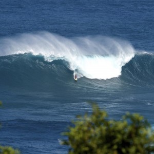
Image: Wangdu Hovey / Pe’ahi Surf Media
Alerts (as of 1:00 a.m.)
A Marine Weather Statement has been issued. A very large northwest swell will affect Hawaii through Thursday night with open ocean swells of 20 feet and surges expected in Kahului harbor. Large breaking waves are also expected at the harbor entrance. Maliko boat ramp will likely also be affected by this swell.
A High Surf Warning is posted for the north and west shores of Molokai and the north shore of Maui through 6 a.m. Friday.
A High Surf Advisory is posted for the west shore of Maui through 6 a.m. Friday.
A Small Craft Advisory is in effect through 6 a.m. Friday for all Maui County waters except Māʻalaea Bay.
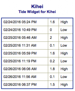
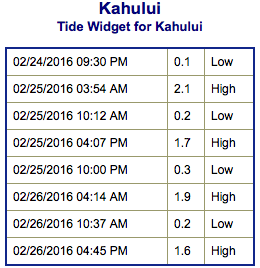
**Click directly on the images below to make them larger. Charts include: Maui County projected winds, tides, swell direction & period and expected wave heights.**
 Maui Surf Forecast
North: Most spots will completely washed out today. The big wave breaks are forecast to get up to 35 to 50+ foot faces with Pe’ahi bringing in 60+ foot waves.
West: Wrap from the northwest swell affecting some western shores today. Spots along the western coast will vary greatly in size based on the amount of exposure.
South: Wave heights are knee/thigh high. Spots with wrap could get up to waist high.
 Our current large northwest swell is expected to build Thursday and peak mid day before gradually fading Friday through the weekend. Wave heights upwards of 45 feet are forecast. Most spots will be washed out but Pe’ahi “Jaws” should see waves upwards of 60 foot faces.
A small southwest swell is expected to show Thursday through Saturday. Another small bump could fill in the first week of March as well.
Keep in mind, surf heights are measured on the face of the wave from trough to crest. Heights vary from beach to beach, and at the same beach, from break to break.
**Click here for your detailed Maui County weather report.**
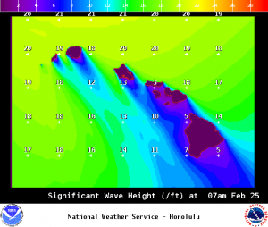
Image: NOAA /NWS
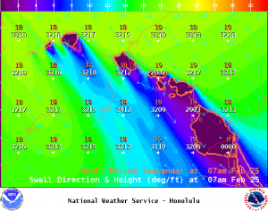
Image: NOAA /NWS
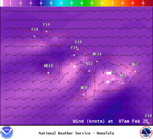
Image: NOAA /NWS
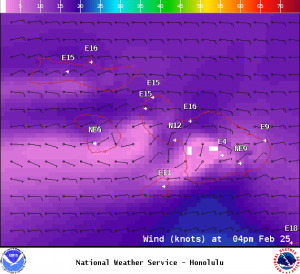
Image: NOAA /NWS
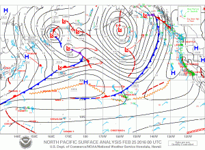
Image: NOAA /NWS
Sponsored Content


