

WINDS, SHOWER BANDS BEGIN ACROSS MAUI TONIGHT: FELICIA 175 MILES ENE OF HILO; WINDS 40 MPH
(Updated: 8 p.m. HST Monday, August 10, 2009 by Wendy Osher)
Gusty winds and shower bands from Felicia will begin spreading across Maui County later tonight. The center is expected to pass very near Maui County Tuesday afternoon.
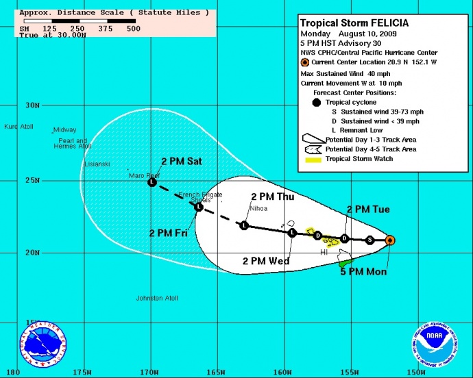
(Click to enlarge image. Cone imagery courtesy NOAA & NWS. Image updated at 5 p.m. 8/10/09)
8:00 pm HST Monday, August, 10 2009, the center of tropical storm felicia was located about 175 miles East-northeast of Hilo, Hawaii and about 340 miles East of Honolulu, Hawaii (near latitude 20.9 north…longitude 152.6 west).
A tropical storm watch remains in effect for Oahu and for all of Maui County, which includes the islands of Maui, Kahoolawe, Lanai, and Molokai. A tropical storm watch means that tropical storm conditions are possible within the watch area, in this case within the next 24 hours.
Felicia is moving toward the west near 10 mph and this motion is expected to continue for the next couple of days. The center of Felicia is expected to reach the Hawaiian Islands on Tuesday with rain bands reaching the islands tonight.
Maximum sustained winds are near 40 mph, with higher gusts. Â Â Weakening is forecast during the next couple of days.
Tropical storm force winds extend outward up to 140 miles from the center.
Estimated minimum central pressure is 1007 MB or 29.74 inches.
A large swell generated by Felicia is already affecting the main Hawaiian Islands. This swell will build across the state tonight and Tuesday. Also, regardless of the intensity of Felicia when it reaches the Hawaiian Islands, locally heavy rainfall may occur and flash flooding remains a possibility.
SUMMARY OF 800 PM HST INFORMATION:
LOCATION…20.9N 152.6W
MAXIMUM SUSTAINED WINDS…40 MPH
PRESENT MOVEMENT…WEST OR 270 DEGREES AT 10 MPH MINIMUM CENTRAL PRESSURE…1007 MB
(Updated @ 8 p.m. HST Monday, August 10, 2009 by Wendy Osher; Information provided by FORECASTER CRAIG at the NWS, Central Pacific Hurricane Center)
Sponsored Content


