Solid NW Swell Peaks Today up to 15 Feet + on Sets

Image: Jimmie Hepp
Alerts (as of 1:00 a.m.)
A Flash Flood Watch is posted through Sunday afternoon.
A High Surf Advisory is posted for east facing shores until 6 p.m. Friday.
A Gale Warning is posted through 6 a.m. Friday for our windiest channels and waters.
A Small Craft Advisory is posted for all remaining Maui County waters through 6 a.m. Saturday.
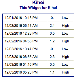
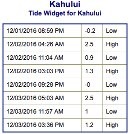
**Click directly on the images below to make them larger. Charts include: Maui County projected winds, tides, swell direction & period and expected wave heights.**
 Maui Surf Forecast
North: Well overhead surf is expected today. The best breaks could get up to double or even triple overhead with 15 to 18 foot faces or more on the sets.
West: Surf is pretty flat today with the best exposures getting up to waist high out of the south-southwest. Northwest Maui will catch some wrap at spots exposed to that direction.
South: Surf is pretty flat today with some spots getting up to waist high on the sets.
 A solid northwest is expected for Friday. Double overhead surf is expected for many breaks with this swell. The best exposures could be triple overhead with 15 foot faces or more. The swell begins to ease over the weekend.
East-northeast trades are creating a trade wind swell for the Hilo side through the next few days.
Our current south-southwest swell is expected to be down to leftovers by Friday. A small southwest is expected to build Sunday and Monday.
Keep in mind, surf heights are measured on the face of the wave from trough to crest. Heights vary from beach to beach, and at the same beach, from break to break.
**Click here for your detailed Maui County weather report.**
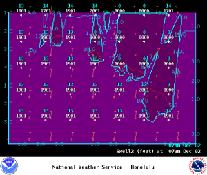
Image: NOAA
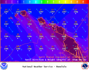
Image: NOAA
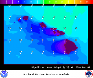
Image: NOAA
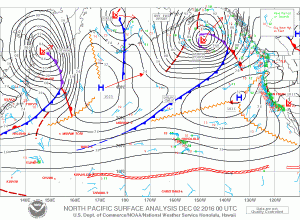
Image: NOAA
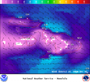
Image: NOAA
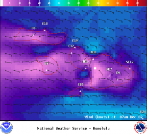
Image: NOAA
Sponsored Content