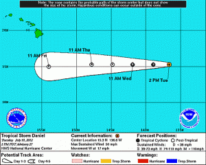
Daniel to Become Remnant Low by Thursday
By Wendy Osher
Tropical Storm Daniel is now located 1200 miles East-Southeast of the Big Island, and is moving west at 15 mph.
Forecasters with the National Weather Service say the system is expected to transition into a remnant low by Thursday, when it will be approximately 700 miles East South East of Hilo, Hawai’i.
According to the NWS outlook, moisture from the system is expected to reach the state on Thursday, bringing increased showers, mainly over windward areas.
Forecasters say rainfall will likely increase in windward areas around the state by around 25% later this week; and increase to 80-90% in mountain areas. Leeward locations will also see the typical isolated showers increase to scattered showers.
The state is expected to get a return of normal trade wind showers through the weekend.


