

High Surf Warning, Dangerous Conditions 2/8/2011 – UPDATE
Editor’s note: The County has issued this statement, warning of dangerous ocean conditions until 6 p.m 2/8/2011:
The National Weather Service in Honolulu has continued the HIGH SURF WARNING for NORTH and WEST FACING SHORES of MOLOKAI and NORTH FACING SHORES of MAUI in effect until 6:00 p.m. this evening.
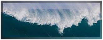
A High Surf Warning indicates that dangerous, battering waves will pound the shoreline. This will result in very dangerous swimming conditions, and deadly rip currents.
Previous Update (2/7/2011)
The National Weather Service has posted a High Surf WARNING for the north facing shores of all islands through 6 p.m.
The large northwest swell is expected to generate warning level surf beginning this morning, with the largest waves expected on the western-most islands.
Surf will be in the 20-30 foot range along the north shores of Niihau and Kauai. Forecasters say surf heights will increase to 20-25 feet today along the north facing shores of Maui and Molokai. The west shores of Molokai can expect surf in the 15-20 foot range. The surf heights are measured by the height of the face of the front of the waves.
A high tide of approximately 1.7 feet is expected between 5:07 p.m. and 6:25 p.m. The next high tide of approximately 1.9 feet is expected between 4:35 and 5:53 tomorrow morning.
Beach goers are urged to stay out of the water and well away from the shore break due to hazardous wave action and strong rip currents. Warning level surf is indicative of dangerous, battering waves that results in dangerous swimming conditions.
(Posted by Wendy Osher; Information courtesy the National Weather Service and Maui County Civil Defense Agency)
File image.
Sponsored Content


