UPDATE: Flossie Impacts Continue, Latest Maui Forecast
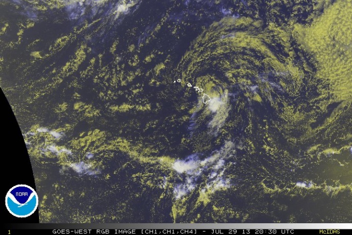
Flossie 10:30 a.m. 7/29/13. Satellite imagery courtesy NOAA/NWS/CPHC.
By Wendy Osher
(Update: 7:48 p.m. 7/29/13)
FLOOD ADVISORY for LANAI, in effect until 11:00 p.m. At 7:48 p.m. radar showed heavy rain over Lanai. The heavy rains are moving west at 15 to 20 mph. Other locations in the advisory include, but are not limited to, Manele Harbor and Lanai City.
(Special Weather Statement MOLOKAI: 7:33 p.m. 7/29/13)
Strong thunderstorms associated with tropical depression Fossie are producing dangerous frequent cloud to ground lightning across Molokai. These thunderstorms may also produce wind gusts near 40 mph. At 7:30 p.m., radar showed a thunderstorm with frequent lighting in the vicinity of Kalaupapa on the north side of Molokai.
(7:32 p.m. 7/29/13)
A FLOOD ADVISORY is in effect for MOLOKAI, until 9:45 p.m. At 6:42 p.m. radar showed heavy rain over Halawa Valley on the northeast portion of Molokai. The area of heavy rain was moving west at 15 to 20 mph.
(7:15 p.m. 7/29/13) Most of the heavy rains have moved west of Maui Island; however runoff remains elevated and will take a while to ease down. A flash flood warning remains in effect until 8:15 p.m.
(Special Report: 6:04 p.m. 7/29/13)
Strong thunderstorms associated with Tropical Depression Flossie are now producing dangerous frequent cloud to ground lightning across Eastern and Central Maui. These thunderstorms may also produce wind gusts near 40 mph, and small hail. If these storms approach your location, seek shelter immediately.
(Update: 5:58 p.m. 7/29/13)
A flash flood warning has been extended for Maui until 8:45 p.m.
At 5:37 p.m., radar and spotters reported rainfall coming down at rates of 4 inches per hour.
The area of heavy rain was moving toward the west at 15 to 20 mph, and will spread into central and West Maui over the next hour, according to forecasters with the National Weather Service.
(Update: 5:24 p.m. 7/29/13)
A Flash Flood Warning has been issued for the island of Maui until 8:15 p.m.
At 5:06 p.m., radar showed heavy rain over east Maui and the south slope of Haleakalā with rain falling at rates of 3 to 4 inches per hour.
Officials from the National Weather Service say the area of rain was moving to the west at 15 miles per hour and will shift from East Maui to Central Maui over the next several hours.
Other locations in the warning include but are not limited to Hāna, Kīpahulu, Kaupo, Keʻanae, Nāhiku, Haʻiku, ʻUlupalakua, Kīhei, Kula, Wailea, Pāia and Kahului.
NWS forecasters say low-water crossings along the Piʻilani Highway in Southeast Maui are especially at risk.
(Update: 4:22 p.m. 7/29/13)
The National Weather Service reports rain moving over the island of Maui at this hour.
At 4:22 p.m., radar showed heavy rain moving onshore near Hāna and developing along the south slope of Haleakalā with rainfall rates of 1 to 2 inches per hour, the NWS and Civil Defense officials report.
The area of rainfall was moving toward the west at 15 miles per hour and will shift from East Maui to Central Maui over the next several hours.
Other locations in the advisory include but are not limited to Hāna, Kīpahulu, Kaupo, Keʻanae, Nāhiku, Haʻikū, ʻUlupalakua, Kīhei, Kula, Pāʻia, Kahului and along the Hāna Highway.A flood advisory is in effect for the island of Maui until 7:30 p.m.
(Update: 2 p.m. 7/29/13)
At 2 p.m., Tropical Storm Flossie was located about 80 miles NNW of Hilo; 60 miles E of Kahului, Maui at its closest approach; and 145 miles E of Honolulu, according to the latest forecast released by the Central Pacific Hurricane Center.
According to NWS forecasters, the system was located near latitude 21.0 north, longitude 155.5 west. Maximum sustained winds are 40 mph, with present movement toward the west northwest at 18 mph. Minimum central pressure is 1000 mb or 29.53 inches.
Flossie is expected to produce total rainfall of 2-4 inches on the Big Island, with isolated windward showers of up to 6 inches. Here on Maui and the rest of the state, rain totals will be 1-2 inches, with isolated amounts of 6 inches in some windward areas, the NWS report stated.
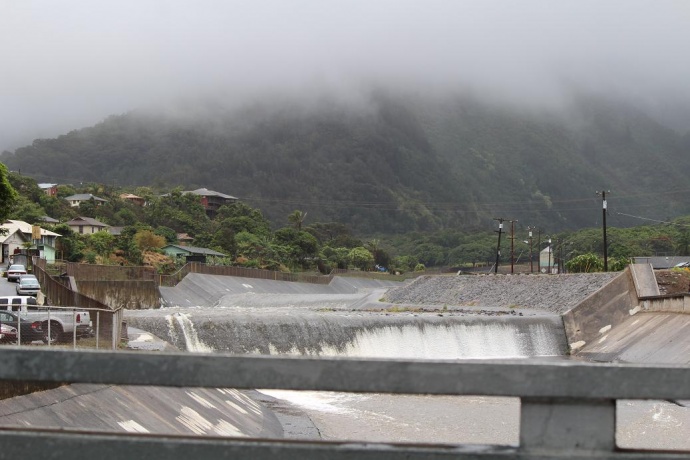
Photo by Wendy Osher, ʻĪao Stream 7/29/13.
“Right now we continue to have tropical storm warnings in effect for all islands in the state,” said Meteorologist Mike Cantin from the Central Pacific Hurricane Center spoke at a press conference this afternoon.
“That means that tropical storm conditions are expected, and a flash flood watch is out for all areas. There is a flash flood advisory for portions of the Big Island where some of the rainfall has already impacted those areas.”
The center of the storm is located, about 65 miles NNE of Hilo (and) 200 or so miles SE of Honolulu, with maximum sustained winds are right around 40 mph, according to Cantin.
“The threshold to be a tropical storm is 39 mph, so this is a low-end tropical storm right now at 40 mph. It’s still moving at a good clip 18 mph to the west and northwest,” he said.
According to Cantin, the storm is still being steered by that ridge of high pressure on the California coast. “It’s been in control of this system throughout its life-cycle coming from east to west, carrying it straight towards us. That will continue as we go through the rest of today and the overnight hours with Flossie as it tracks to the west and north west.”
Cantin said visible satellite imagery shows the low-level center of the circulation is now fully exposed.
“When we see the tropical cyclones, as the low becomes exposed, what happens is it looses some of the moisture and some of the energy from any storms that are spinning around. Now all the convection, all the thunderstorm activity and rain showers are now down to the south of the circulation. The low itself has lost one of its source of energy, that leads to a rapid weakening of the system. That’s what we’ve seen as we’ve gone through the overnight hours and into this morning as that low has been exposed.”
Cantin said there is an area of moderate to heavy rainfall that’s now impacting the Big Island that will be dragged to the northwest as the low tracks. “There’s still the potential for some heavier rain showers and some minor flooding as the system tracks that way,” he said.
According to Cantin, the center of the storm is located to the northeast of the Big Island, and is tracking just north of due west as it crosses the state. “It is forecast to become a tropical depression, with winds less than 39 mph in the next 12 hours or less,” he said.
“The tropical storm force winds are diminishing. What we’ve seen from our satellite passes over the system is that the winds are tropical storm force strength on the northeast side of the low-level circulation. In general, the winds around the circulation have dropped below tropical storm force at this point,” said Cantin.
(Update: 11 a.m. 7/29/13)
Tropical Storm Flossie is weakening as it makes its way toward Maui, forecasters from the National Weather Service said in their latest update.
At 11 a.m., Flossie was located 65 miles N/NE of Hilo, Hawaiʻi; 95 miles NE of Kailua-Kona; 130 miles N/NE of South Point; 100 miles E/SE of Kahului; 150 miles E SE of Kaunakakai; 130 miles E of Lānaʻi City; 200 miles E/SE of Honolulu; 295 miles E/SE of Līhuʻe; and 345 miles E/SE of Niʻihau.
The storm was near latitude 20.6 north, longitude 154.9 west.
According to the Central Pacific Hurricane Center, the system had sustained winds of 40 mph with present movement toward the W/NW at 18 mph. Tropical storm force winds extend outward up to 70 miles from the center.
Minimum central pressure is 1000 mb or 29.53 inches.
Tropical storm conditions are expected to reach portions of Maui County early this afternoon.
The National Weather Service revised projections saying heavy rainfall is expected to produce total amounts of 1 to 2 inches, with isolated maximum amounts up to 6 inches.
The NWS says the Big Island is projected to receive slightly more rain than the rest of the state, with 2 to 4 inches expected, and isolated amounts up to 6 inches.
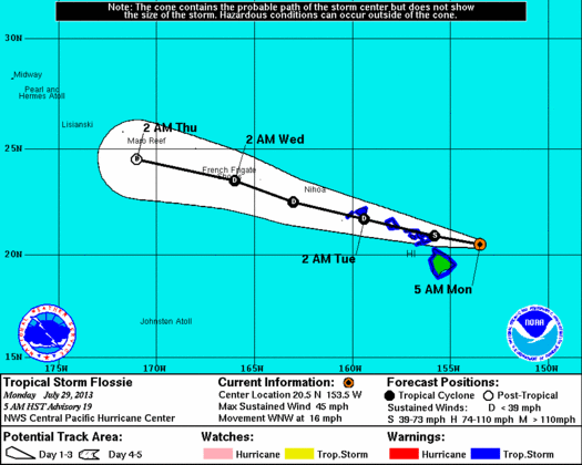
Flossie 5-day track, 5 a.m. 7/29/13. Image courtesy NWS/NOAA/CPHC.
(Update: 8 a.m. 7/29/13)
At 8 a.m., Tropical Storm Flossie was located 80 miles NE of Hilo; 140 miles E/NE of Kailua-Kona; 150 miles NE of South Point; 160 miles E/SE of Kahului, Maui; 210 miles E/SE of Kaunakakai; 190 miles E of Lānaʻi City; 260 miles E/SE of Honolulu; 355 miles E/SE of Līhuʻe; and 405 miles E/SE of Niʻihau.
The center of the system was last tracked at latitude 20.4 N and longitude 154.0 W, according to Central Pacific Hurricane Center reports.
Maximum sustained winds are at 40 mph, with tropical storm force winds extending outward up to 90 miles from the center; Present movement is WNW at 20 mph; and minimum central pressure is 1000 mb or 29.53 inches, according to the CPHC.
According to the National Weather Service, tropical wind conditions are expected to reach the Big Island this morning, Maui County by late morning, Oʻahu this evening, and Kauaʻi County later tonight.
Heavy rain is expected to begin this morning over Hawaiʻi County and this afternoon over Maui, NWS forecasters say. Flossie is still expected to produce rainfall totals of 6 to 10 inches over Maui and Hawaiʻi Island, with isolated amounts of 15 inches possible in some windward areas.
Forecasters say 4 to 8 inches are possible over Oʻahu and Kauaʻi, with isolated maximum amounts of 12 inches possible, mainly over windward areas.
This rainfall, NWS forecasters say, could cause life-threatening flash floods and mud slides, especially in mountain areas.
On the water, forecasters say, “Dangerously high surf is hammering east facing shores of the Big Island.”
The NWS forecast calls for surf to spread to the rest of the islands today and continue into Tuesday, with surf expected to be in the 10 to 20-foot range, and coastal flooding possible.
Authorities say the big surf may cause coastal road closures, even before the storm arrives.
(Update: 5 a.m. Monday, July 29, 2013)
A tropical storm warning remains in effect for Maui, Oʻahu, and Hawaiʻi Counties. At 5 a.m., Kauaʻi and Niʻihau were added to the warning area.
As of 5 a.m., Tropical Storm Flossie was located at 110 miles E/NE of Hilo; 170 miles E/NE of Kailua-Kona; 180 miles NE of South Point; 190 miles E of Kahului, Maui; 245 miles E of Kaunakakai; 220 miles E of Lānaʻi City; 290 miles E/SE of Honolulu; 385 miles E/SE of Līhuʻe; and 435 miles E/SE of Niʻihau, according to information released by the Central Pacific Hurricane Center.
The center of the system was last tracked at latitude 20.5 N and longitude 153.5 W, according to CPHC reports.
Maximum sustained winds are at 45 mph; present movement is WNW at 16 mph; and minimum central pressure is 1000 mb or 29.53 inches, according to the CPHC.
According to the National Weather Service, tropical wind conditions are expected to reach the Big Island this morning, Maui County by late morning, Oʻahu this evening, and Kauaʻi County later tonight.
Heavy rain is expected to begin this morning over Hawaiʻi County and this afternoon over Maui, NWS forecasters say. Flossie is still expected to produce rainfall totals of 6 to 10 inches over Maui and Hawaiʻi Island, with isolated amounts of 15 inches possible in some windward areas.
(Update: 2 a.m. Mon. July 29, 2013)
A tropical storm warning remains in effect for Maui, Oʻahu, and Hawaiʻi Counties; and a Tropical Storm Watch is in effect for Kauaʻi and Niʻihau.
At 2 a.m., Tropical Storm Flossie was located: 160 miles E of Hilo; 270 miles E/SE of Kahului; 320 miles E/SE of Kaunakakai; 295 miles E/SE of Lānaʻi City; 370 miles E/SE of Honolulu; 465 miles E/SE of Līhuʻe; and 515 miles E/SE of Niʻihau, according to information released by the Central Pacific Hurricane Center.
The system had maximum sustained winds of 50 mph, with tropical storm force winds extending outward up to 100 miles from the center. NWS forecasters say some weakening in the winds are forecast during the next 48 hours.
Sponsored Content


_(2)_1751920774087.webp)