

Forecasters Monitor Pacific for Storm Potential
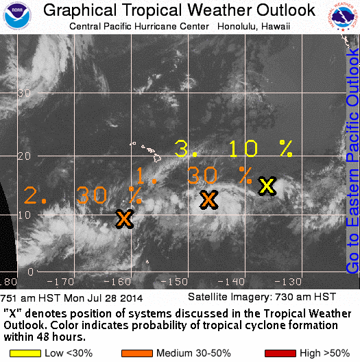
The remnant low of former tropical depression Genevieve is currently located about 715 miles southeast of Hilo, Hawaii. Image courtesy NOAA/NWS/Central Pacific Hurricane Center.
By Wendy Osher
The Central Pacific Hurricane Center continues to monitor the Pacific for potential storm activity with several systems showing up on satellite imagery.
Forecasters with the National Weather Service say the remnant low of former tropical depression Genevieve was located about 715 miles southeast of Hilo on Monday morning, July 28, 2014.
A tropical weather outlook issued by the Central Pacific Hurricane Center shows that conditions may be somewhat conducive for redevelopment of the system.
In the interim, the storm continues to move west near 10 mph.
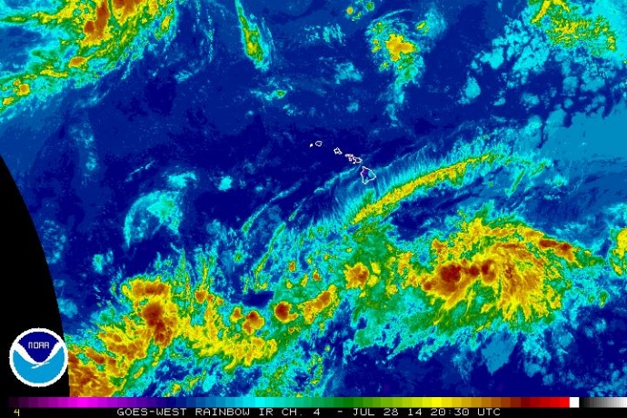
Central Pacific satellite imagery for 7/28/14. Image courtesy NOAA/NWS/Central Pacific Hurricane Center.
A separate “elongated area of showers and thunderstorms” was located about 700 miles south southwest of Hawaiʻi Island at last report.
Forecasters with the Central Pacific Hurricane Center say the both systems have a medium 30% chance of tropical cyclone formation over the next two days.
A third system was located about 1350 miles east of Hawaiʻi Island and was producing “disorganized showers and a few thunderstorms,” according to the NWS tropical weather outlook. The system has a much lower 10% chance for development over the next two days, forecasters said.
The National Hurricane Center was issuing advisories for Tropical Storm Hernan, which was still located in the eastern North Pacific, a few hundred miles west southwest of the southern tip of Baja California.
The National Weather Service is forecasting windward and mauka showers carried by trade winds over the next several days, and an increase in humid conditions late in the week as moisture moves in from the southeast.
There is currently a small craft advisory in effect until 6 p.m. HST on Wednesday, July 30, 2014, for Māʻalaea Bay, the Pailolo Channel between Maui and Molokaʻi, the ʻAlenuihāhā Channels between Hawaiʻi Island and Maui, and Hawaiʻi Island leeward and southeast waters.
The hurricane season in Hawaiʻi runs from June 1 to November 30, 2014.

Genevive 5-day track. Image courtesy NOAA/NWS/Central Pacific Hurricane Center.

The National Hurricane Center is issuing advisories on Tropical
Storm Hernan, located a few hundred miles west-southwest of the
southern tip of the Baja California peninsula. Image courtesy NWS/NOAA/Central Pacific Hurricane Center.
Sponsored Content


