

Ana Impacts: Funnel Cloud or Dust Devil?
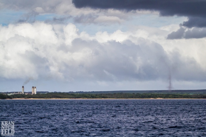
Photo by Lyle Krannichfeld. https://www.facebook.com/krannichfeldphoto
By Wendy Osher
Maui photographer Lyle Krannichfeld sent us this photo of possible funnel cloud taken at around 3:30 p.m. on Friday, Oct. 17, 2014, offshore from Kīhei aboard the Pacific Whale Foundation’s Ocean Voyager vessel.
We asked authorities if the occurrence was consistent with the type of weather that we can expect from Ana as it passes south of the state.
Bob Burke from the
National Weather Service in Honolulu responded saying, “Since the convection is rather shallow, it looks like a large dust devil since it appears to be kicking up some dirt near the ground.”
NWS colleague, Chris Brenchley also commented saying, “This looks like a large, well developed dust devil that has been going for a while.”
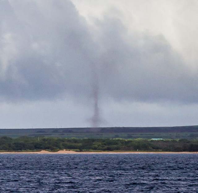
Photo by Lyle Krannichfeld. https://www.facebook.com/krannichfeldphoto
The agency defines a dust devil as, “a small, rapidly rotating wind that is made visible by the dust, dirt or debris it picks up. Also called a whirlwind, it develops best on clear, dry, hot afternoons.”
The National Weather Service defines a funnel cloud as, “a condensation funnel extending from the base of a towering cumulus or Cb, associated with a rotating column of air that is not in contact with the ground (and hence different from a tornado). A condensation funnel is a tornado, not a funnel cloud, if either (a) it is in contact with the ground or (b) a debris cloud or dust whirl is visible beneath it.”
At 5 p.m. HST, on Friday, Oct. 17, Hurricane Ana was moving toward the northwest near 13 mph, and had maximum sustained winds near 80 mph.
On its updated current forecast track, authorities with the Central Pacific Hurricane Center say the center of Ana will pass about 150 miles southwest of the Big Island tonight and about 175 miles southwest of the rest of the main Hawaiian islands this weekend.
The system was located 215 miles SSW of Hilo and 270 miles S of Kahului, Maui at 5 p.m. on Friday, Oct. 17, 2014.
The agency says some additional strengthening is possible through tonight, followed by gradual weakening late Saturday and Sunday.
Meteorologist Malika Dudley has outlined the possible impacts to Maui County in her latest update.
***If you have photos of news happening on Maui or weather related images from Hurricane Ana, please send them to newsdesk@mauinow.com for us to share.
Sponsored Content


