Remnants of Fernanda May Affect Hawai‘i Late This Weekend
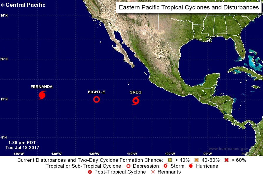
Forecasters are currently tracking three systems in the Eastern Pacific including Hurricane Fernanda, Tropical Storm Greg and Tropical Depression 8E.
Hurricane Fernanda continues a gradual weakening trend over the next two days and is forecast to become a tropical storm by Wednesday, July 19, 2017. Forecasters with the National Weather Service say that although it’s too early to be certain, increased moisture associated with the remnants of Fernanda may affect Hawaiʻi late this weekend and early next week.
As of 5 a.m. HST (8 a.m. PDT) on Tuesday, July 18, 2017, Fernanda was located 1460 miles E of Hilo, Hawaiʻi and was moving NW at 9 mph.
The system had maximum sustained winds of 100 mph, and was classified as a Category 2 (96-110 mph winds) hurricane on the Saffir-Simpson scale.
Tropical Storm Greg was located about 380 miles SW of Manzanillo, Mexico. The system had maximum sustained winds of 40 mph and was moving W at 9 mph at last report. The NHC says slow strengthening is forecast during the next 48 hours.
Forecasters with the National Hurricane Center say: “Although the ridge is expected to remain in place for the next several days, a slight complicating factor in the track forecast is a cyclone, newly formed Tropical Depression Eight-E, located about 500 n mi to the west of Greg. Some of the models indicate that Greg could interact with the other cyclone in a few days by turning south of west. The official forecast shows a slightly south of westward motion in the latter part of the period.”
Tropical Depression Eight-E has also formed in the Eastern Pacific and was located about 830 miles SW of the Southern Tip of Baja California. The system had maximum sustained winds of 35 mph and was moving W at 5 mph. Little change in strength is forecast during the next couple of days, according to the NHC.
According to most forecast models, the depression will move slowly southwestward during the next couple of days until Greg passes to the north in about 72 hours.
The National Hurricane Center says: “The strong vertical wind shear currently over the cyclone is expected to continue during the next day or two, and the official forecast show no strengthening during this time. In about 3 days, a more favorable upper-level pattern could materialize, but given the uncertainty about the structure of the tropical cyclone at that time and the potential interaction of nearby Tropical Storm Greg, the NHC intensity forecast does not reflect much change in wind speed.”
Fernanda Advisory #027. 8 a.m. PDT (5 a.m. HST) Tues Jul 18, 2017. PC: NOAA/NWS/National Hurricane Center; Greg Advisory #006. 3 p.m. MDT Tues Jul 18, 2017. PC: NOAA/NWS/National Hurricane Center; Disturbance 8E #002. 2 p.m. PDT Tues Jul 18, 2017. PC: NOAA/NWS/National Hurricane Center.
Fernanda Advisory #027. 8 a.m. PDT (5 a.m. HST) Tues Jul 18, 2017. PC: NOAA/NWS/National Hurricane Center; Greg Advisory #006. 3 p.m. MDT Tues Jul 18, 2017. PC: NOAA/NWS/National Hurricane Center; Disturbance 8E #002. 2 p.m. PDT Tues Jul 18, 2017. PC: NOAA/NWS/National Hurricane Center.
Fernanda Advisory #027. 8 a.m. PDT (5 a.m. HST) Tues Jul 18, 2017. PC: NOAA/NWS/National Hurricane Center; Greg Advisory #006. 3 p.m. MDT Tues Jul 18, 2017. PC: NOAA/NWS/National Hurricane Center; Disturbance 8E #002. 2 p.m. PDT Tues Jul 18, 2017. PC: NOAA/NWS/National Hurricane Center.
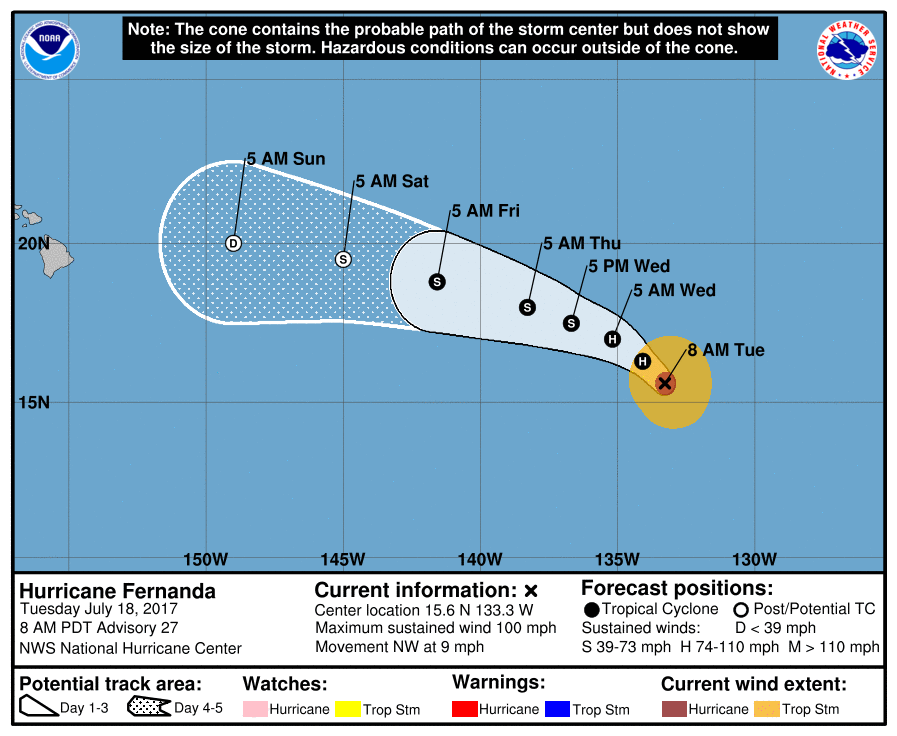
Fernanda Advisory #027. 8 a.m. PDT (5 a.m. HST) Tues Jul 18, 2017. PC: NOAA/NWS/National Hurricane Center.
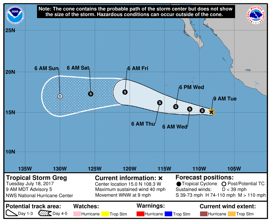
Greg Advisory #006. 3 p.m. MDT Tues Jul 18, 2017. PC: NOAA/NWS/National Hurricane Center.
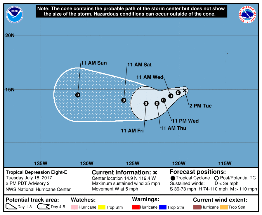
Disturbance 8E #002. 2 p.m. PDT Tues Jul 18, 2017. PC: NOAA/NWS/National Hurricane Center.
Sponsored Content