Summit is “Quiet,” Lava Flow Greatly Diminished at Fissure 8
The lava flow from Fissure 8 in the Lower East Rift Zone of the Kīlauea volcano is greatly diminished and deflation at the summit of Halema’uma’u has slowed with few, if any, felt earthquakes, according to the Hawaiian Volcano Observatory.
Meanwhile, the summit of Halema’uma’u is very quiet, and has slowed deflating, with few if any felt quakes. The last collapse event at the summit was noon on Thursday, Aug. 2, 2018.
The HVO reminds the public to be aware that the hazards associated with the eruption that began May 3 remain, including active lava in the channel flowing from Fissure 8 into the ocean. There was also a significant increase in gas emissions from Pu’u ‘O’o on Friday.
“It could be weeks or months before we feel comfortable calling the eruption and the summit collapse over, said Tina Neal, the scientist-in-charge at HVO. She noted that it is typical for eruptions to wax and wane.
Neal suggested that people read reports on hazard assessments on the HVO website, specifically regarding when and how eruptions end.
Work on an emergency bypass road adjacent to Highway 11 in Volcano is ongoing. The tremors at the Halema’uma’u summit have destabilized Highway 11, the only artery connecting Ka’u to the rest of the island.
The County is cooperating with Federal and State agencies on the construction of the two-mile bypass. There is no precise time frame on when the bypass road will be completed, but the County recognizes the urgency of the situation as the new school year starts this week.

Looking more directly into the fissure 8 vent on Sunday morning (Aug. 5, 2018), the inner walls of the cone and lava surface could be seen. The level of lava within the vent and spillway (left) were down compared to Saturday. A dark crust, which forms as the lava surface cools, had formed on the lava with the spillway. PC: USGS Aug. 5, 2018

Incandescent lava remained visible in a section of the fissure 8 channel west of Kapoho Crater (just visible at far left). This view is looking south toward the ocean; the laze plume rising from the ocean entry can be seen in the far distance. PC: Aug. 5, 2018 courtesy USGS

Here’s another “then and now” look at Halema‘uma‘u (view is to north). At left, Halema‘uma‘u, as we once knew it, and the active lava lake within the crater are visible on April 13, 2018. At right is a comparable viewshed captured on July 28, 2018, following recent collapses of the crater. The Hawai‘i Volcanoes National Park Jaggar Museum and USGS-HVO can be seen perched on the caldera rim (middle right) with the slopes of Mauna Loa in the background. PC: Aug. 5, 2018 courtesy USGS
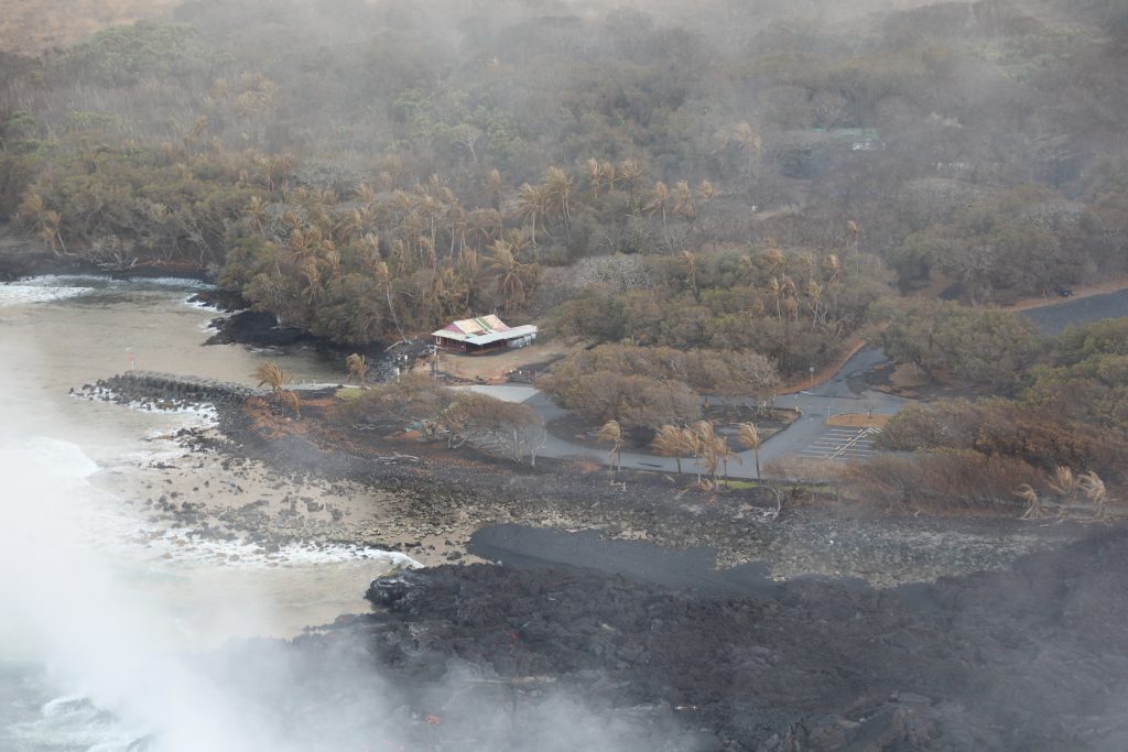
Another view of Isaac Hale Beach Park and the Pohoiki boat ramp from Sunday morning’s overflight (Aug. 5, 2018) . The active ocean entry and laze plume can be seen at lower left. PC: Aug. 5, 2018 courtesy USGS

view of the viscous pāhoehoe flow entering the ocean near Isaac Hale Beach Park on Sunday morning Aug. 5, 2018. PC: USGS
Sponsored Content