

Eruption at Kīlauea Summit Caldera
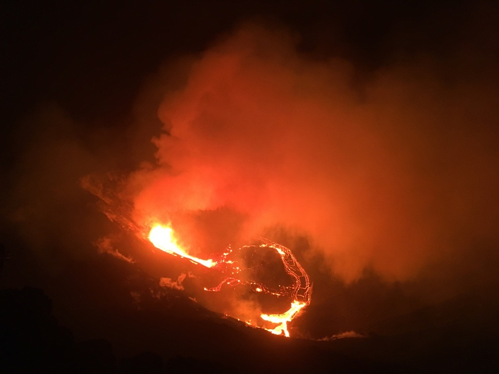
 The easternmost vent is currently exhibiting fountains up to approximately 50 m (164 ft) high with minor fountaining on the west side. Occasion blasts of uncertain origin are occurring from lava lake surface. USGS photo.
- An eruption started at Kīlauea summit on December 20 at approximately 9:30 p.m. HST with multiple fissures opening on the walls of Halemaʻumaʻu crater. The lava cascaded into the summit water lake, boiling off the water and forming a new lava lake at the base of the crater. The northern fissure, pictured, was producing the tallest lava fountain at roughly 50 m (165 ft), and all lava was contained within Halemaʻumaʻu crater in Kīlauea caldera. USGS photo.
- A steam and gas plume from the eruption in Halemaʻumaʻu crater at Kīlauea summit. Lava contained within the crater illuminates the steam produced by the lava interacting with, and boiling off, the summit water lake that resided in the base of Halemaʻumaʻu crater. USGS photo.
- Kīlauea’s summit eruption at 2:15 a.m. HST on December 21. From the west rim of Kīlauea caldera, a gas plume can be seen rising from Halemaʻumaʻu crater. This plume is drifting to the southwest with the trade winds. Increased sulfur dioxide (SO2) emission rates associated with new eruption may lead to voggy conditions downwind. USGS photo.
- ANIMATED GIF: This animated image file (GIF) includes a series of webcam images—one image every two minutes—from the F1cam thermal camera located on the western rim of Halema‘uma‘u crater, Kīlauea summit. The images are in a continuous loop showing the first few hours of the summit eruption which started on December 20. The first image is from 9:20 p.m. HST, approximately 10 minutes prior to the start of the eruption, and the final image was taken at 1:06 a.m. HST on December 21. USGS GIF by L. DeSmither.


Update: 11:15 a.m. 12.21.20
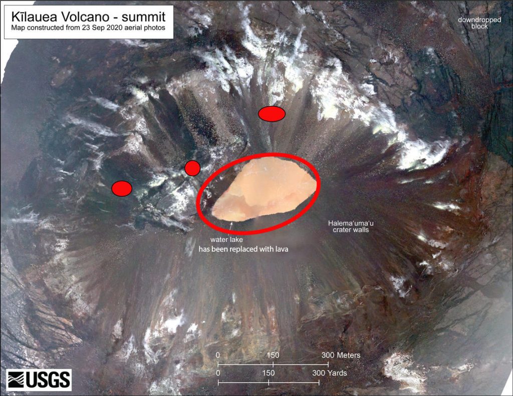
The USGS Hawaiian Volcano Observatory reports that the water lake at the summit of Kīlauea has boiled away and “an effusive eruption has commenced, with three vents in the wall of Halemaʻumaʻu crater generating lava flows that are contributing to a growing lava lake at the base of Halemaʻumaʻu crater.”
The eruption is currently confined to Halemaʻumaʻu crater. and the HVO has decreased Kīlauea’s volcano alert level to WATCH and its aviation color code to ORANGE, reflecting the less-hazardous nature of the ongoing eruption.
Volcanic Activity Summary:
An eruption has commenced within Kīlauea’s summit caldera. Shortly after approximately 9:30 last night, the USGS Hawaiian Volcano Observatory reports it detected a glow within Halemaʻumaʻu crater at the summit of Kīlauea Volcano observed fountains of lava approximately 164 feet high.
Accordingly, the HVO has elevated Kīlauea’s volcano alert level to “warning” and its aviation color code to “red.”
The water lake at the base of Halema‘uma‘u crater has been replaced with a growing lava lake, with occasional blasts of uncertain origin occurring from lava lake surface, according to the HVO. “The easternmost vent is currently exhibiting fountains up to approximately 164 feet high with minor fountaining on the west side,” the HVO reports.
The information below is the latest observations, background history and prognosis provided by the HVO:
Recent Observations:
For the past several weeks, the USGS Hawaiian Volcano Observatory has recorded ground deformation and earthquake rates at Kīlauea Volcano’s summit and upper East Rift Zone that have exceeded background levels observed since the conclusion of the 2018 lower East Rift Zone eruption and summit collapse.
Beginning in September 2020, increased rates of uplift were observed by GPS stations in Kīlauea’s upper East Rift Zone. In the past month, increased uplift has also been measured at GPS stations in Kīlauea’s summit region. While uplift related to post-collapse inflation of the summit reservoir has been occurring since March of 2019, rates have been steadily increasing in recent months and are currently higher than they have been since the end of the 2018 eruption.
In late November 2020, increased earthquake rates began when seismic stations recorded an average of at least 480 shallow, small-magnitude earthquakes (97% of which were less than or equal to magnitude-2) per week occurring at depths of less than 4 km (2.5 miles) beneath Kīlauea’s summit and upper East Rift Zone. This compares to a rate of fewer than 180 per week following the end of Kīlauea’s 2018 eruption and through early November 2020.
On December 2, 2020, GPS stations and tiltmeters recorded a ground deformation event at Kīlauea’s summit. Accompanied by earthquake swarms, the patterns of ground deformation observed were consistent with a small dike intrusion of magma under the southern part of Kīlauea caldera. The injection resulted in about 8 cm (3 inches) of uplift of the caldera floor, and modeling suggests that it represented 0.4–0.7 million cubic meters (yards) of magma accumulated approximately 1.5 km (1 mile) beneath the surface. Though the intrusion did not reach the surface and erupt, it represented a notable excursion from trends observed in Kīlauea summit monitoring data streams following the end of the 2018 eruption.
On December 17, 2020, seismometers detected a notable increase in occurrence and duration of long-period seismic signals beneath Kīlauea’s summit, which are attributed to magmatic activity. Whereas this type of seismicity was observed on average once every few weeks following the 2018 eruption, rates have increased to over a dozen in the past several days.
An earthquake swarm began on the evening of December 20, accompanied by ground deformation detected by tiltmeters. An orange glow was subsequently observed on IR monitoring cameras and visually beginning approximately 21:36 HST.
Background
Since the early 1800s, when written records of Hawaiian volcanoes began, Kīlauea has had infrequent periods during which no lava erupted.
The longest known eruptive pause was in 1935-1952, ending with eruption in the caldera. Neither that 17-year pause, nor any other shorter pause, followed partial collapse of the caldera such as the collapse that occurred in the summer of 2018.
Following partial caldera collapses, the first eruption outside the caldera took place on the East Rift Zone 17 years after the 1823 collapse, on the Southwest Rift Zone 28 years after the 1840 collapse, and on the Southwest Rift Zone 52 years after the 1868 collapse.
After partial caldera collapses in 1840 and 1868, lava returned to the caldera within days to a few weeks. The length of the current pause exceeds those earlier post-collapse pauses.
Kīlauea Volcano has maintained a low level of non-eruptive unrest since the end of the 2018 lower East Rift Zone eruption and summit collapse, which deepened Halemaʻumaʻu crater by over 500 meters (1640 feet). Following the 2018 eruption, ground deformation rates have indicated steady inflation of Kīlauea’s summit and at the end of 2018, the HVO monitoring network detected Deflation-Inflation events (DI-events) indicative that the shallow Halemaʻumaʻu magma reservoir, located approximately 1.6 km (1 mile) under Kīlauea caldera, still contained significant amounts of magma.
In late July 2019, ponded water appeared at the base of the deepest collapsed area of Kīlauea’s summit, within the Halemaʻumaʻu crater. Since then, the body of water has grown into a lake, which continues to rise as it seeks equilibrium with the surrounding groundwater.
Prognosis
All communities on or near Kīlauea’s summit and rift zones should be prepared.
HVO continues to monitor the volcano closely and will report any significant changes. HVO is in close touch with National Park Service and Hawaii County Civil Defense and other agencies responsible for public safety.
Sponsored Content


