

Volcano Watch: What’s That Rising From the Lava Lake?
by US Geological Survey Hawaiian Volcano Observatory scientists and affiliates
The past year has seen fluctuating lava lakes, ephemeral lava fountains, craggy spires, and drifting “islands” reminiscent of pre-1924 Halemaʻumaʻu activity at the summit of Kīlauea. The recent activity has USGS Hawaiian Volcano Observatory scientists reflecting on prior observations and how they compare to recent activity.
The last eruption of Halemaʻumaʻu began Dec. 20, 2020, and created a lava lake at the base of the crater with striking topographic relief across its surface. Part of this relief formed the first night of the eruption.
A broad, high, light brown to tan feature—made up of less-dense material—appeared to be floating in the lava lake. Over the next week, it migrated around the lake based on flow directions from vents active at the time, eventually halting in the center of the lake.
HVO geologists found this feature to be reminiscent of the “floating islands” described by Kīlauea summit observers a century ago and earlier. As the eruption waned in intensity, more of these features formed in a variety of sizes and heights; all eventually became stationary. Contemporary geologists suggest that raft may be a better term to describe these features, which we continue to learn about with the new eruption at Kīlauea’s summit.
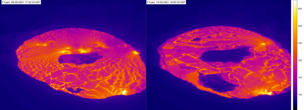
The current Halemaʻumaʻu eruption started at 3:21 p.m. HST on Sept. 29, 2021, as lava fountains erupted from a north-south-trending crack in the crust of the December 2020-May 2021 lava lake surface. A thermal camera monitoring Halemaʻumaʻu documented the eruption start, showing a new lava lake rising rapidly and covering many of the island features formed during the previous eruption.
By the time geologists arrived for visual observations about an hour after this new eruption began, only the largest island, a small island to the northeast, and part of the high-standing west vent system from the December 2020 eruption remained above the surface of the new rising lava lake. Several hours later, the northeast island was submerged by lava and the highest point of the large central island was only 33 feet above the surface of the new lava lake.
It seemed apparent that the newly forming lava lake was going to continue rising and eventually cover all remnant topography of the earlier eruption. However, as the eruption progressed, the height of the large island above the lava lake surface started to increase. Islands that geologists saw being submerged in new lava soon also started to reappear.
The smaller island in the northeast part of the lava lake—that was submerged at around 5:20 p.m. HST—reappeared a little over an hour later. Over the next few days, more islands within the eastern and northern part of the lava lake would re-emerge above the lava lake surface. The largest island now has a high point that is 66 feet above the active surface of the lava lake.
It’s unclear why these islands—or rafts—that were only a few days ago submerged by the lava lake have reappeared. The recently cooled and solidified crust of lava erupted during the December 2020–May 2021 eruption seems to be buoyant in a way that is allowing for it to gradually float up within the new molten lava erupted in the past week.
It seems unlikely that these are individual pieces of crust detaching from the old, solidified lava lake floor and rising up. If that were the case, at least some of the smaller island would then migrate around the lava lake as lava flows moving outward from the active vents push them around. All of the islands appear to be stationary except for floating vertically upward so it’s likely that all or large chunks of the older lava lake floor are moving upward together.
Similar lava lake behavior was observed by Thomas A. Jaggar, founder of HVO, about a century ago. However, Halemaʻumaʻu crater was much smaller then, about a one-fifth or twenty percent of its size today. Detailed documentation of activity at Kīlauea over the past century allows for these observations, made decades apart, to be compared. As lava lakes rise and fall, so, too, do islands or rafts!
Volcano Activity Updates
Kīlauea volcano is erupting. Its USGS Volcano Alert level is at WATCH.
Kīlauea volcano is erupting. Lava continues to erupt from two vents: one on the floor and one in the western wall of Halemaʻumaʻu crater. All lava activity is confined within Halemaʻumaʻu crater in Hawai‘i Volcanoes National Park. Sulfur dioxide emission rates remain high and were estimated at around 7,000 tonnes per day on Oct. 6, 2021. Seismicity is elevated but stable, with few earthquakes and ongoing volcanic tremor. Summit tiltmeters continued to record slowing deflationary tilt through this afternoon.
Mauna Loa is not erupting and remains at Volcano Alert Level ADVISORY. This alert level does not mean that an eruption is imminent or that progression to an eruption from the current level of unrest is certain.
This past week, about 110 small-magnitude earthquakes were recorded below the summit and upper elevation flanks of Mauna Loa—the majority of these occurred at shallow depths less than 5 miles. Global Positioning System measurements show no major deformation over the past week. Gas concentrations and fumarole temperatures at both the summit and at Sulphur Cone on the Southwest Rift Zone remain stable. Webcams show no changes to the landscape.
There were 11 events with 3 or more felt reports in the Hawaiian Islands during the past week, but some reports may have been mis-attributed to the wrong event. Listed here are the most likely felt events with magnitudes above 3: a M3.6 earthquake 4 miles E of Pāhala at 19 mile depth on Oct. 5 at 8:39 p.m. HST, a M4.5 earthquake 4 miles ENE of Pāhala at 20 mile depth on Oct. 5 at 8:36 p.m. HST, a M3.5 earthquake 0 miles S of Pāhala at 22 mile depth on Oct. 4 at 7:17 a.m. HST, a M3.4 earthquake 5 miles ENE of Pāhala at 20 mile depth on Oct. 2 at 9:59 a.m. HST, and a M3.1 earthquake 4 miles W of Kailua-Kona at 4 mile depth on Oct. 1 at 8:09 p.m. HST.
HVO continues to closely monitor Kīlauea’s ongoing eruption and Mauna Loa for any signs of increased activity.
Volcano Watch is a weekly article and activity update written by US Geological Survey Hawaiian Volcano Observatory scientists and affiliates.
Sponsored Content


