

Tsunami Advisory Ends for Hawaiʻi following volcanic eruption in Tonga; Maui impacts reported

Tsunami Advisory Ends for the State of Hawaiʻi
Update: 7:54 a.m. / 9:02 a.m. Saturday, Jan. 15, 2022
The tsunami advisory that was in effect for Hawaiʻi has since been cancelled as of 7:52 a.m. on Saturday, Jan. 15, 2022.
The Pacific Tsunami Warning Center says tsunami wave heights across the state are now below advisory levels and are continuing to diminish.
The PTWC reports, “Small sea level changes and strong or unusual currents may persist for several additional hours in some coastal areas and appropriate caution should be exercised by boaters and swimmers.”
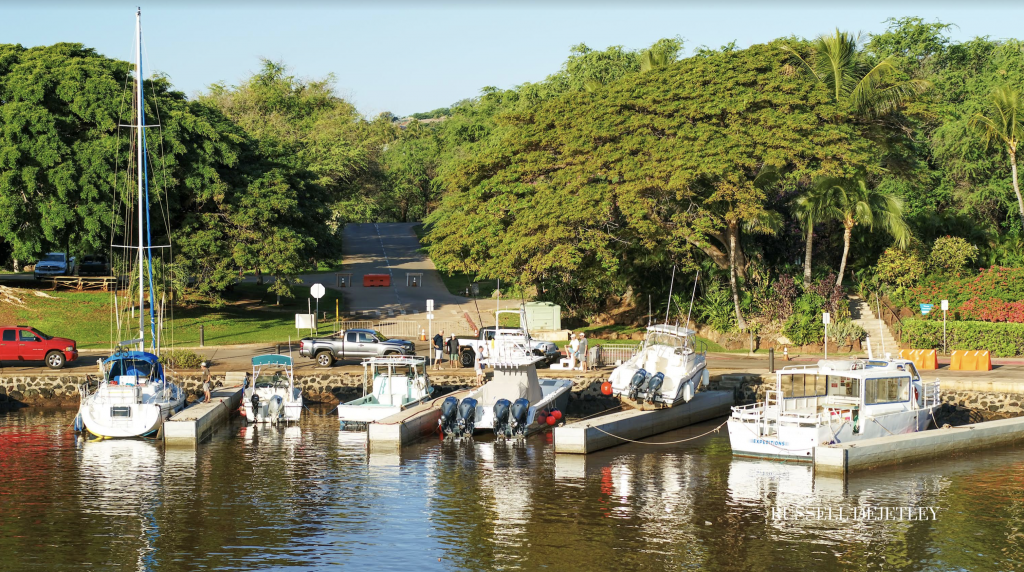
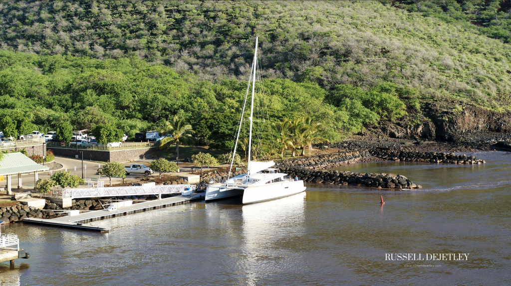
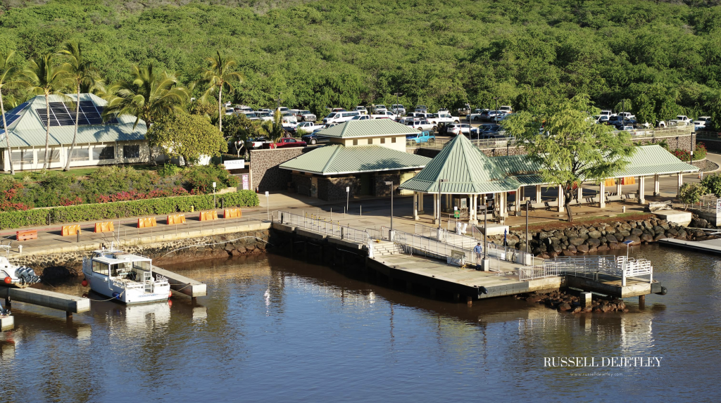
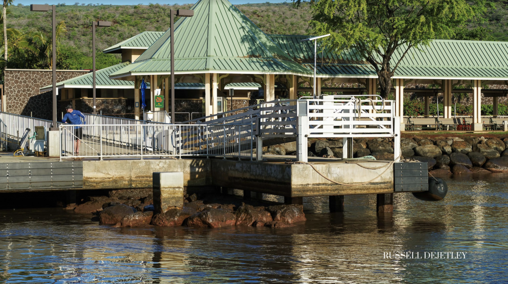
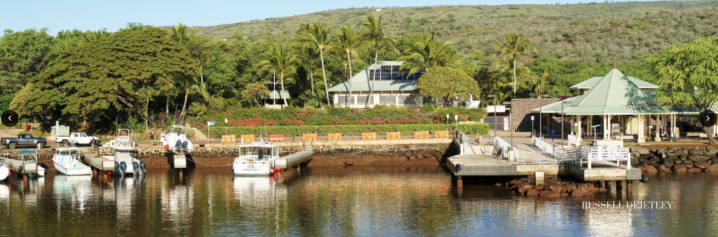
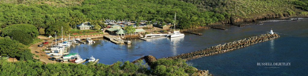
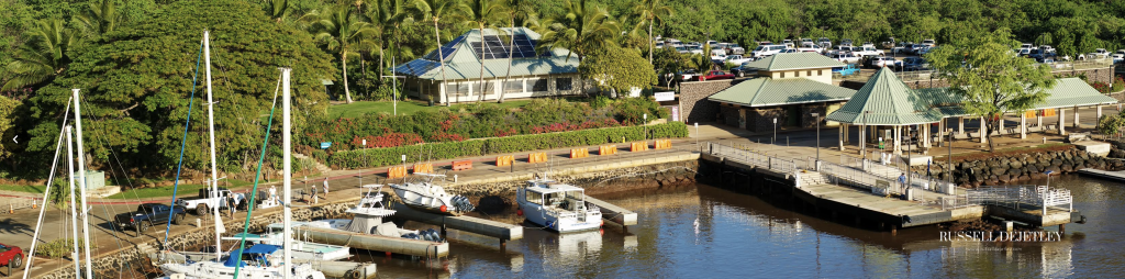
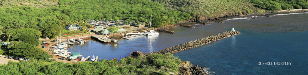
The Maui County Emergency Management Agency reports this morning that tsunami waves lifted a boat from its moorings in Mānele Harbor, Lānaʻi, and washed debris ashore in the East Maui area of Hāna, closing a road near Hāmoa Beach Park. Assessment of impacts is ongoing.
Just before 5:30 a.m., Maui police reported that Haneoʻo Road in Hāna was closed between Koki Beach and Hāmoa Beach “due to numerous tree logs and debris brought by water surge.” The road was reopened before 6 a.m.
 Aerial Images of Mānele Harbor on Lānaʻi. Photos: (1.15.22) Russell deJetley
- Aerial Images of Mānele Harbor on Lānaʻi. Photos: (1.15.22) Russell deJetley
- Aerial Images of Mānele Harbor on Lānaʻi. Photos: (1.15.22) Russell deJetley
- Aerial Images of Mānele Harbor on Lānaʻi. Photos: (1.15.22) Russell deJetley
- Aerial Images of Mānele Harbor on Lānaʻi. Photos: (1.15.22) Russell deJetley
- Aerial Images of Mānele Harbor on Lānaʻi. Photos: (1.15.22) Russell deJetley
- Aerial Images of Mānele Harbor on Lānaʻi. Photos: (1.15.22) Russell deJetley
- Aerial Images of Mānele Harbor on Lānaʻi. Photos: (1.15.22) Russell deJetley
- Aerial Images of Mānele Harbor on Lānaʻi. Photos: (1.15.22) Russell deJetley
- Aerial Images of Mānele Harbor on Lānaʻi. Photos: (1.15.22) Russell deJetley


The original Tsunami Advisory was issued at 12:40 a.m. HST on Saturday, Jan. 15, as a result of the eruption at the Hunga-Tong-Hunga-Ha’apai volcano in Tonga.
“Although no major tsunami was expected to strike Hawai‘i, the water displaced by the volcanic activity caused unusual sea level changes and alterations to typical sea currents starting at about 1:05 a.m. Saturday,” according to the Hawaiʻi Emergency Management Agency.
The State Emergency Operations Center at HI-EMA was partially activated to monitor the evolving situation.
In an update issued shortly after 9 a.m., HI-EMA reported: “At this time, no casualties, injuries, or major damage has been reported, but the Hawaiʻi Emergency Management Agency (HI-EMA) will continue to work with local partners to assess any damages and impacts.”
“While the advisory has been canceled, swimmers and boaters, as well as people on shore in coastal areas are advised to use caution and to follow their local emergency management officials to know when it is safe to return to the water,” according to HI-EMA.
Tsunami Advisory Supplement
Update: 6:40 a.m. Saturday, Jan. 15, 2022
A tsunami advisory continues in effect for the state of Hawaiʻi following a volcanic eruption that occurred at 6:27 p.m. on Jan. 14, 2022 in Tonga.
The Pacific Tsunami Warning Center says “tsunami wave oscillations across the state of Hawaiʻi continue to diminish, but are not yet all below tsunami advisory level.”
The Maui County Emergency Management Agency reports this morning that tsunami waves lifted a boat from its moorings in Mānele Harbor, Lānaʻi, and washed debris ashore in the East Maui area of Hāna, closing a road near Hāmoa Beach Park. Assessment of impacts is ongoing.
“I ask everyone near the shoreline to be vigilant and exercise caution,” Mayor Michael Victorino said. “We will continue to monitor the impacts of this tsunami.”
Note: Dart measurements are from the deep ocean and they generally are much smaller than would be coastal measurements at similar locations, according to the PTWC
“Tsunami waves that can be a hazard to swimmers and boaters as well as to persons near the shore at beaches and in harbors and marinas are now affecting the state of Hawaiʻi. This hazard could continue for several hours. The situation is being monitored closely and the advisory will end when the hazard has passed,” the agency advises.
Future messages will be issued hourly or sooner as conditions warrant until the threat to Hawaiʻi has passed.
The PTWC says maximum tsunami wave amplitudes for Kahului, Maui are 2.7 feet. Other wave amplification heights across the state include: 2.7 feet at Hanalei, Kauaʻi; 2.3 feet at Haleiwa; 1.2 feet at Honokohau and Kawaihae; and 0.4 feet at Honolulu.
The Maui Emergency Management Agency says, “No evacuation is necessary but tsunami waves with the potential for producing strong currents or waves dangerous to those in or very near the water is expected or occurring. There may be flooding of beach and harbor areas. Stay out of the water and away from beaches and waterways. Follow instructions from local officials.”
As a precautionary measure, tsunami waves can be a hazard to swimmers and boaters as well as to persons near the shore, at beaches, and in harbors and marinas, and is now affecting the State of Hawaii. This hazard may continue for several hours; the situation is being monitored closely and the advisory will end when the hazard potential has passed.
At 10:07 p.m. on Friday, Jan. 14, the Pacific Tsunami Warning Center issued its first advisory for Hawaiʻi saying that based on all available data, there was no tsunami threat to Hawaiʻi. That was replaced with a Tsunami Advisory Supplement at 1:51 a.m., saying tsunami waves can be a hazard to swimmers and boaters, as well as persons near shore at beaches and in harbors and marinas now affecting the state.
The following list provides maximum tsunami amplitudes so far on gauges across the Pacific:
GAUGE LOCATION LAT LON TIME AMPL PER
——————- —– —— —– ————— —–
CHICHIJIMA JP 27.1N 142.2E 1344Z 0.74M / 2.4FT 14MIN
VODOPADNAYA RU 51.7N 158.0E 1434Z 0.45M / 1.5FT 12MIN
KUSHIRO JP 43.0N 144.4E 1411Z 0.40M / 1.3FT 42MIN
TOSASHIMIZU SHIKOKU 32.8N 133.0E 1537Z 0.93M / 3.0FT 30MIN
OMAEZAKI HONSHU JP 34.6N 138.2E 1526Z 0.71M / 2.3FT 22MIN
EASTER CL 27.2S 109.4W 1530Z 0.32M / 1.0FT 04MIN
DART 46403 52.7N 156.8W 1431Z 0.06M / 0.2FT 14MIN
DART 46409 55.3N 148.6W 1520Z 0.04M / 0.1FT 14MIN
DUTCH HBR UNALASKA 53.9N 166.5W 1452Z 0.09M / 0.3FT 36MIN
KING COVE AK 55.1N 162.3W 1449Z 0.32M / 1.1FT 16MIN
ATKA AK 52.2N 174.2W 1358Z 0.22M / 0.7FT 20MIN
NIKOLSKI AK 52.9N 168.9W 1528Z 0.36M / 1.2FT 12MIN
LIHOU REEF AU 17.1S 152.1E 1241Z 0.12M / 0.4FT 14MIN
GOLD COAST SAND BYP 27.9S 153.4E 1135Z 0.70M / 2.3FT 42MIN
PORT KEMBLA AU 34.5S 150.9E 1206Z 0.39M / 1.3FT 32MIN
TWOFOLD BAY AU 37.1S 149.9E 1205Z 0.67M / 2.2FT 48MIN
SPRING BAY AU 42.5S 147.9E 1041Z 0.35M / 1.1FT 70MIN
HIVA OA MARQUESAS 9.8S 139.0W 1026Z 0.53M / 1.8FT 12MIN
NUKU HIVA MARQUESAS 8.9S 140.1W 1055Z 0.67M / 2.2FT 12MIN
HANALEI HI 22.2N 159.5W 1233Z 0.82M / 2.7FT 14MIN
KAHULUI MAUI 20.9N 156.5W 1228Z 0.83M / 2.7FT 20MIN
RIKITEA PF 23.1S 135.0W 1038Z 0.21M / 0.7FT 14MIN
HUAHINE PF 16.7S 151.0W 0813Z 0.53M / 1.8FT 12MIN
NAURU 0.5S 166.9E 1118Z 0.15M / 0.5FT 04MIN
GISBORNE EASTLAND N 38.7S 178.0E 1141Z 0.68M / 2.2FT 42MIN
KAWAIHAE HAWAII 20.0N 155.8W 1132Z 0.37M / 1.2FT 10MIN
HONOKOHAU HI 19.7N 156.0W 1145Z 0.34M / 1.1FT 10MIN
HALEIWA HI 21.6N 158.1W 1138Z 0.70M / 2.3FT 10MIN
HONOLULU OAHU 21.3N 157.9W 1112Z 0.12M / 0.4FT 14MIN
BARBERS PT HI 21.3N 158.1W 1135Z 0.19M / 0.6FT 04MIN
MAKAI PIER WAIMANAL 21.3N 157.7W 1128Z 0.28M / 0.9FT 10MIN
HILO HAWAII 19.7N 155.1W 0929Z 0.10M / 0.3FT 16MIN
NAWILIWILI KAUAI 22.0N 159.4W 1057Z 0.31M / 1.0FT 12MIN
HIENGHENE NEW CALED 20.7S 164.9E 0910Z 0.45M / 1.5FT 10MIN
VANUATU 17.8S 168.3E 0924Z 1.41M / 4.6FT 20MIN
RAROTONGA CK 21.2S 159.8W 0853Z 0.90M / 3.0FT 02MIN
GREAT BARRIER IS NZ 36.2S 175.5E 0849Z 0.70M / 2.3FT 10MIN
OWENGA CHATHAM NZ 44.0S 176.4W 0902Z 0.44M / 1.4FT 40MIN
KINGSTON NORFOLK IS 29.1S 168.0E 0840Z 0.78M / 2.6FT 10MIN
LUGANVILLE VU 15.5S 167.2E 0826Z 0.37M / 1.2FT 24MIN
OUINNE NEW CALEDONI 22.0S 166.7E 0826Z 1.13M / 3.7FT 08MIN
THIO NEW CALEDONIA 21.6S 166.2E 0819Z 0.57M / 1.9FT 20MIN
LIFOU NEW CALEDONIA 20.9S 167.3E 0746Z 0.89M / 2.9FT 16MIN
EAST CAPE NZ 37.6S 178.2E 0834Z 0.26M / 0.8FT 08MIN
DART401002 29.7S 175.0W 0542Z 0.10M / 0.3FT 28MIN
DART401001 36.0S 177.7W 0612Z 0.07M / 0.2FT 24MIN
SUVA VITI LEVU FJ 18.1S 178.4E 0633Z 0.26M / 0.9FT 18MIN
DART401003 23.4S 173.4W 0442Z 0.12M / 0.4FT 42MIN
NUKUALOFA TO 21.1S 175.2W 0516Z 0.82M / 2.7FT 06MIN
PAGO PAGO AS 14.3S 170.7W 0531Z 0.62M / 2.0FT 16MIN
APIA UPOLU WS 13.8S 171.8W 0551Z 0.17M / 0.5FT 18MIN
LAT – LATITUDE (N-NORTH, S-SOUTH)
LON – LONGITUDE (E-EAST, W-WEST)
TIME – TIME OF THE MEASUREMENT (Z IS UTC IS GREENWICH TIME)
AMPL – TSUNAMI AMPLITUDE MEASURED RELATIVE TO NORMAL SEA LEVEL.
IT IS …NOT… CREST-TO-TROUGH WAVE HEIGHT.
VALUES ARE GIVEN IN BOTH METERS(M) AND FEET(FT).
PER – PERIOD OF TIME IN MINUTES(MIN) FROM ONE WAVE TO THE NEXT.
Sponsored Content


