


Volcano Watch: Ups and downs at Kīlauea Summit – Quiescence, eruptions, change
Volcano Watch is a weekly article and activity update written by US Geological Survey Hawaiian Volcano Observatory scientists and affiliates.
May 3, 2023, marked the fifth anniversary of the start of Kīlauea’s historic 2018 eruption that resulted in extensive lava flows from the East Rift Zone and major collapses of the summit caldera floor. Since that 2018 activity, Kīlauea has experienced nearly constant change with distinct episodes of calm, unrest, eruptions and everything in between.

When we think about volcanoes, we often first think of eruptions and lava. However, there is more to volcanoes than alluring molten rock appearing at Earth’s surface. Even when a volcano isn’t actively erupting lava, it is often still changing shape and deforming. These movements cause the Earth’s surface to change, which scientists call “ground” or “surface deformation.”
Measuring surface deformation is one of the main ways that scientists at the Hawaiian Volcano Observatory (HVO) monitor activity at Hawaiian volcanoes. If the ground surface surrounding a volcano is moving upwards (towards the sky), the volcano is inflating and expanding. If the surface is moving downwards (towards the center of the Earth), it is interpreted that the volcano is deflating.
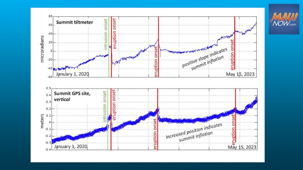
Surface deformation on the Island of Hawaiʻi is measured primarily with three techniques: tiltmeters, GPS (Global Positioning System), and satellite InSAR (Interferometric Synthetic Aperture Radar). These measurements give scientists clues about how ground motion is related to magma movement below the surface of a volcano and what could potentially come next. Rapid changes in the rate of deformation often precede or accompany new eruptive activity.
At Kīlauea volcano, we are used to constant deformation and change. Following the large lower East Rift Zone eruption from May–August 2018, Kīlauea began a period of calm during which HVO’s deformation instruments measured almost no significant surface movements. Then in March 2019, tiltmeters and GPS instruments started to measure uplift once again, indicating inflation of the summit.
That inflation continued relatively steadily until Dec. 2, 2020, when there was an abrupt and rapid increase in uplift rates (approximately 15 centimeters or 6 inches of uplift over a couple of days), which were interpreted to be the result of a magma intrusion into the shallow reservoir of magma beneath Halemaʻumaʻu crater.
On the night of Dec. 20, 2020, Halemaʻumaʻu started erupting lava again and the water lake in the crater boiled away. The onset of this eruption was immediately followed by over 20 centimeters or 8 inches of downward motion at the summit within a day or two of lava appearing at the surface.
Only a few weeks after lava returned to Halemaʻumaʻu, Kīlauea began to inflate again, and the ongoing uplift at the summit continued. Though the December 2020 eruption eventually ended in May 2021, the summit maintained steady inflation from January 2020 until September 29, 2021, which marked the onset of the next eruption at Halemaʻumaʻu. As with the December 2020 eruption, significant deflation also followed the start of the September 2021 eruption.
After this initial, drastic deflation at the end of September 2021, the summit of Kīlauea remained steady and didn’t significantly deform—despite an ongoing eruption—until early summer of 2022, when it started to steadily inflate once again. The Sept. 29, 2021, eruption eventually ended on Dec. 9, 2022, even as inflation continued. This inflation ultimately led to the Jan. 5, 2023, eruption, which later ended around March 7, 2023.
The past five years have been dynamic at Kīlauea’s summit, with inflation, intrusions, eruptions, and deflation. Currently, overall rates of surface deformation show moderate inflation at Kīlauea’s summit and there is no active eruption. Though Kīlauea is quiet on the surface, it can be easy to forget that Kīlauea is still deforming—which means magma is coming into the system—and that activity can change very quickly. Rest assured that a team of scientists at HVO are constantly monitoring all our Hawaiian volcanoes, looking for real-time changes in deformation—or any other signal—that may suggest an impending eruption.
Volcano Activity Updates
Kīlauea is not erupting. Its USGS Volcano Alert level is ADVISORY.
Webcams show no signs of active lava in Halemaʻumaʻu crater, at the summit of Kīlauea in Hawai‘i Volcanoes National Park. Over the past week, summit tiltmeters showed inflation and seismicity has been variable. The summit sulfur dioxide (SO2) emission rate was most recently measured on May 16, when it totaled 150 tonnes per day.
Mauna Loa is not erupting. Its USGS Volcano Alert Level is at NORMAL.
Webcams show no signs of activity on Mauna Loa. Seismicity remains low. Summit ground deformation rates show inflation above background levels, but this is not uncommon following eruptions. SO2 emission rates are at background levels.
There were seven earthquakes above magnitude 3 and with three or more felt reports in the Hawaiian Islands during the past week:
- M3.4 earthquake 10 km (6 mi) ENE of Pāhala at 32 km (20 mi) depth on May 16 at 8:09 p.m.
- M3.1 earthquake 2 km (1 mi) S of Volcano at 0 km depth occurred on May 16 at 7:15 a.m.
- M3.0 earthquake 15 km (9 mi) S of Fern Forest at 6 km (3 mi) depth on May 15 at 4:50 p.m.
- M3.0 earthquake 4 km (2 mi) SSE of Pāhala at 30 km (19 mi) depth on May 13 at 7:41 p.m.
- M3.1 earthquake 13 km (8 mi) ESE of Pāhala at 29 km (18 mi) depth on May 13 at 2:31 a.m.
- M3.5 earthquake 3 km (1 mi) SSW of Pāhala at 33 km (20 mi) depth on May 12 at 4:24 p.m.
- M3.4 earthquake 10 km (6 mi) ENE of Pāhala at 31 km (19 mi) depth on May 12 at 4:26 a.m.
Visit HVO’s website for past Volcano Watch articles, Kīlauea and Mauna Loa updates, volcano photos, maps, recent earthquake information, and more. Email questions to askHVO@usgs.gov.
Sponsored Content


