

Maui County wetlands map to help mitigate flooding, protect environment
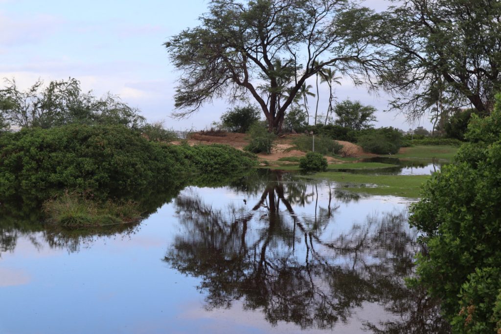
 Pictured here are anchialine pools at La Perouse in South Maui. A new public tool will chart existing and identify future wetlands to help mitigate flooding risks and protect the environment. PC: Wesley Crile / University of Hawaiʻi Sea Grant College Program
- Pictured here are anchialine pools at La Perouse in South Maui. A new public tool will chart existing and identify future wetlands to help mitigate flooding risks and protect the environment. PC: Wesley Crile / University of Hawaiʻi Sea Grant College Program
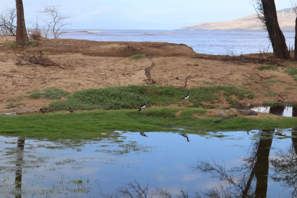
- Maui County wetlands at Waipuilani in South Maui. A new public tool will chart existing and identify future wetlands to help mitigate flooding risks and protect the environment. PC: Wesley Crile / University of Hawaiʻi Sea Grant College Program
- Maui County wetlands at Waipuilani in South Maui. A new public tool will chart existing and identify future wetlands to help mitigate flooding risks and protect the environment. PC: Wesley Crile / University of Hawaiʻi Sea Grant College Program
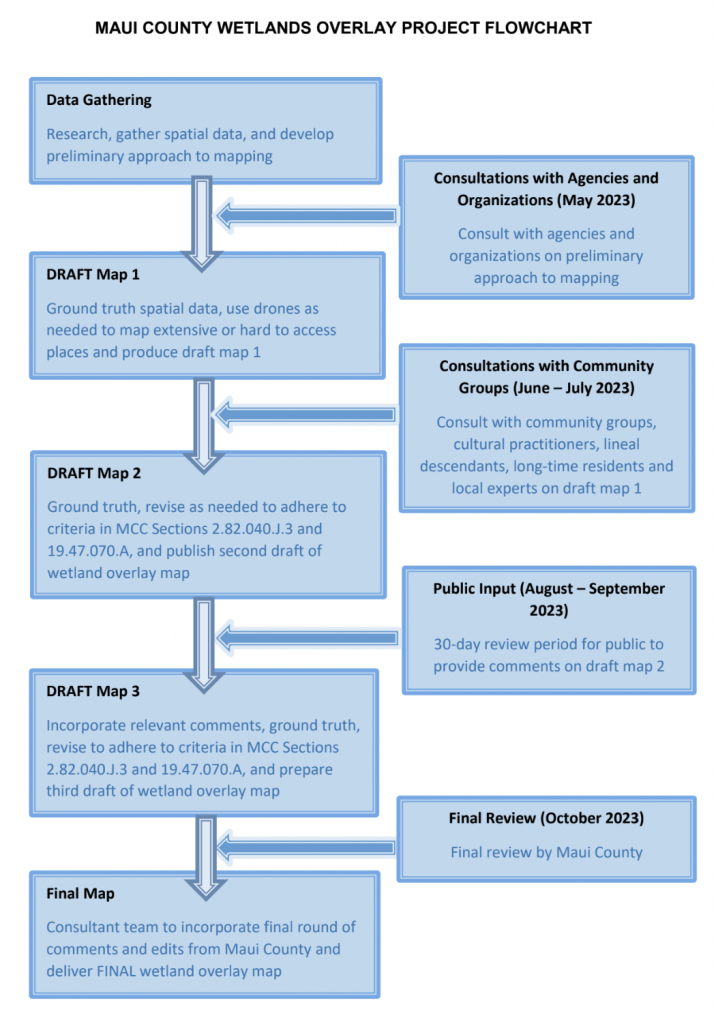
- Flowchart illustrates the Maui County Wetlands Overlay Project. Credit: County Planning Department


The county’s Department of Planning is creating a public tool that will help reduce flood risk for human life and property while protecting and restoring Maui County’s important natural wetland ecosystems, county officials announced.
As part of a new county law to restore and protect wetlands, titled Ordinance 5421, Planning officials are working on a comprehensive wetlands overlay map that will identify existing and future wetland areas.
Once it is launched on the County of Maui website, the map will help property owners, land managers and county planners with important land-use decisions, according to department officials.
“Wetlands are valuable features in the landscape that provide a number of beneficial services, including safeguarding and improving water quality, providing wildlife habitat sanctuaries and reducing coastal storm damage,” Planning Director Kathleen Ross Aoki said in a news release. “Protecting wetlands will also help to mitigate flood hazards and protect life and property in Maui County.”
Consultation work is being done now, and discussions with community groups will start in June and July. The final draft of the map needs to be finished within a year of the passage of the new law, which took effect in October. Along the way, review from the public, government agencies and other stakeholders will be required before the map is completed.
The map will chart wetlands throughout the county and include potential future wetland areas by assessing passive flooding data that incorporates the effects of climate change, such as sea level rise. The map will also include environmentally sensitive areas such as isolated wetlands, estuaries, streams and other waterways. South Maui is the first area scheduled for mapping.
Wetlands generally include swamps, marshes, bogs and estuarine systems, along with flowing, intermittent or ephemeral streams and their drainages. They are areas inundated or saturated by surface or groundwater at a frequency and duration sufficient to support — and under normal circumstances do support — a range of specialized vegetation.
Aside from providing essential habitat for many native plants and animals, wetlands offer flood prevention, pollution reduction and climate regulation.
Consultants H.T. Harvey & Associates, who have experts in wetland policy, Hawaiian wetland ecology and mapping, were recently selected to help develop the map. Also, the University of Hawaiʻi Sea Grant Program is providing technical support on the map.
The final map is intended to be a “living document” that can be amended and improved over time
with the latest science and continuing input from the community.
The wetlands overlay map is part of a larger project led by the University of Hawaiʻi Sea Grant Program that aims to reduce flood risk and increase resiliency for the community by mapping other environmentally sensitive areas – especially considering traditional mauka to makai, ahupuaʻa-based land management systems that are unique to Hawaiʻi.
The larger Wetlands Overlay Project will eventually guide policy for wetlands restoration and protection, such as considering wetlands for possible acquisition, amending areas to allow for wetland protection and restoration, and updating zoning laws.
More information on the project is available online.
Sponsored Content


