


Google Street View Teams with Business to Track Maui Hikes
By Dave Smith
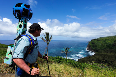
Hawaii Forest and Trail President Rob Pacheco sports the Trekker equipment as he prepares for a descent into Pololu Valley in North Kohala. Google Maps Blog photo.
A number of select hiking trails on Maui – and others around Hawaii – will be the subject of a new program allowing third-party organizations to contribute images to Google Maps.
The partnership with Hawaii Visitors and Convention Bureau is the first for Google Maps involving its Street View Trekker equipment.
The 40-pound Trekker camera pack is a modified backpack that takes 360-degree images.
A team from Google Maps has been on the Big Island this past week introducing the equipment to staff from Hawaii Forest and Trail, a Kona-based eco-tourism company selected by the visitor’s bureau to assist with the project.
Hawaii Forest and Trail is helping the bureau identify appropriate trails and will also provide personnel to carry the Trekker and walk the trails to gather imagery.
HFT personnel will officially begin collecting still images in July. Those images, and the list of featured trails, which will be added to Google Maps later this year.
Google Street View is a technology featured in Google Maps and Google Earth that provides 360-degree panoramic views from many streets in the US and elsewhere in the world. Launched in 2007, it was created through the use of specially modified cars and other vehicles.
HVCB will later move on to capture photos from Oahu, Kauai, Maui, Lanai and Molokai, although the order and timeline is reportedly not final.
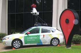
A Google Maps Street View vehicle. Google.com photo.
“We are absolutely thrilled and honored to be selected as Google Maps’ first partner to borrow a Trekker, and to have the privilege of working with one of the world’s leading technology companies to enhance the way travelers can connect with the Hawaiian Islands,” John Monahan, HVCB’s president and CEO, said in a statement.
“Maps and panoramic imagery serve an integral role in the vacation planning process,” he said. “Incorporating this interactive and immersive technology on our gohawaii.com site once it’s processed and available online will deliver a powerful travel planning tool for potential Hawai‘i visitors across the globe.”
Jay Talwar, HVCB’s chief marketing officer, said Hawaii Forest and Trail and its co-founder and president, Rob Pacheco, were an obvious choice to participate in the program because of their “impeccable reputation, decades of experience in the eco-tourism business, and a capable staff.”
“We are confident they will be able to deliver with integrity,” Talwar said.
“Our partnership with HVCB and Google Maps on this project will allow us to play a direct role in mapping the places we know so well, and to visually showcase to the world the beauty and fragility of areas in Hawai‘i that many may otherwise never see,” Pacheco said.
Sponsored Content


