

WNW Fading, Trade Swell Builds to Advisory Levels

Image: Jimmie Hepp
Alerts (as of 1:00 a.m.)
High Wind Watch: In effect from noon Saturday through Saturday night for strong northeasterly winds accompanying a weak front and behind it. Winds will accelerate through mountain passes, at higher elevations and on downsloping leeward sides. The strongest winds will be in the lee of mountains, across much of Lāna’i and Kaho’olawe and through the central valley of Maui.
High Surf Advisory: East shores of Molokai and Maui from noon Saturday.
Small Craft Advisory: All coastal waters and channels through noon Saturday.
Gale Warning: In effect from Saturday at noon through Sunday at 6 a.m. for all offshore waters and coastal waters and channels.
**Click directly on the images below to make them larger. Charts include: Maui County projected winds, tides, swell direction & period and expected wave heights.**
 Maui Surf Forecast
North: Surf is head high to a few feet overhead. The best breaks are still getting up to double overhead on the sets in the morning. Showing best for Ho’okipa eastward. Trade swell builds up to chest/head high around Hana.
West: Surf is knee/waist high today. Spots catching some of the west-northwest wrap will be bigger.
South: Surf is knee/waist high today. The best spots catching the wrap could get bigger.
 Our current elevated west-northwest swell eases late Saturday into Sunday. Another swell is expected on the 25th as well.
A High Surf Advisory is posted for east facing shores due to the high winds generating a trade swell for those areas. Surf will be very messy in these areas.
A small southwest swell is forecast for the 22nd through the 24th but only up to about knee/waist high.
Keep in mind, surf heights are measured on the face of the wave from trough to crest. Heights vary from beach to beach, and at the same beach, from break to break.
**Click here for your detailed Maui County weather report.**
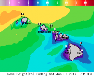
Image: NOAA

Image: NOAA
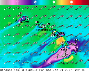
Image: NOAA
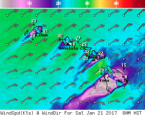
Image: NOAA
Image: NOAA
Sponsored Content


