

Update: Hurricane Kiko re-intensifies to a Category 4 as it approaches the Central Pacific basin
Update: (11 a.m., Sept. 5, 2025)
Kiko has re-intensified to a category 5 hurricane on its approach to the Central Pacific basin.
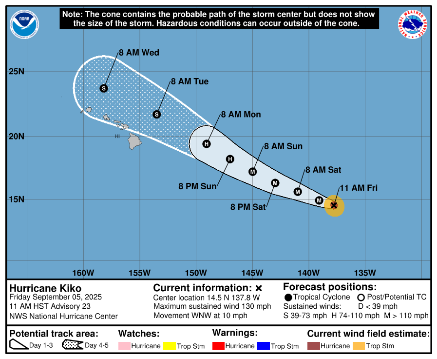
At 11 a.m. HST, Hurricane Kiko was located about 1195 miles ESE of Hilo and 1400 miles ESE of Honolulu, Hawaiʻi. The National Hurricane Center reports that Kiko is moving toward the west-northwest near 10 mph, and this motion is expected to continue over the next few days.
“On the forecast track, Kiko is expected to move into the central Pacific basin by tomorrow
morning,” the NHC reports.
Maximum sustained winds have increased to near 130 mph with higher gusts, and additional strengthening is expected this afternoon and tonight before slow weakening begins on Saturday, according to the latest update from the HNC.
According to the latest forecast, hurricane-force winds extend outward up to 25 miles from the center and tropical-storm-force winds extend outward up to 70 miles. The estimated minimum central pressure is 951 mb (28.09 inches).
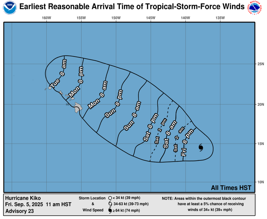
The NHC reports that swells generated by Hurricane Kiko could begin reaching the Hawaiian Islands towards the end of this weekend.
According to a NHC forecast discussion: Kiko is forecast to approach the Hawaiian Islands during the early to the middle portion of next week. “Impacts from rain and wind remain a possibility, but it is too soon to determine the exact location or magnitude of these impacts, and interests there should continue to monitor the progress of this storm.”
Previous post: (5 a.m., Sept. 5, 2025)
Hurricane Kiko is now moving to the WNW well to the ESE of Hawaiʻi. Kiko is expected to cross into the central Pacific basin by tonight, according to the National Weather Service.
At 5 a.m. HST, the center of Hurricane Kiko was located 1245 miles ESE of Hilo, Hawaiʻi and was moving toward the WNW near 9 mph. This motion is expected to continue for the next few days, according to the National Hurricane Center.
Maximum sustained winds have decreased to near 115 mph with higher gusts, enough to maintain a category 3 status on the Saffir-Simpson Hurricane Wind Scale. Fluctuations in intensity are expected during the next 48 hours followed by weakening by early next week, according to the NHC.
Hurricane-force winds extend outward up to 25 miles from the center and tropical-storm-force winds extend outward up to 70 miles. The estimated minimum central pressure is 962 mb (28.41 inches), according to the latest forecast.
“Primarily windward rainfall will increase in response to approaching Tropical Cyclone Kiko early next week. Kiko is forecast to reach our far eastern offshore waters Monday. There is a fair amount of uncertainty that exists concerning Kiko’s eventual track, intensity and possible impacts,” according to the National Weather Service.
On the water, swells generated by Hurricane Kiko could begin reaching the Hawaiian Islands towards the end of this weekend. NHC forecasters say these swells could cause life-threatening surf and rip currents.
A forecast discussion issued by the National Hurricane Center notes that “Kiko should convectively sputter while moving very close to the eastern end of the Hawaiian Island chain as a weakening tropical storm,” however, interests in the Hawaiian Islands should monitor the Kiko’s progress.
Hawaiʻi Synopsis
The National Weather Service is forecasting a partly cloudy and warm day with light to moderate trade winds over the next couple of days.
“The islands are under a stable weather pattern as weak ridging remains situated over and east of the state. Limited showers will be primarily confined to windward upslope mauka and within higher terrain through Saturday,” the NWS reports.
Forecasters say an area of enhanced moisture moving through early Sunday will increase statewide precipitation chances.
Keeping watch on other systems
The National Hurricane Center has issued the final advisory on Post-Tropical Cyclone Lorena, located just off the west coast of Baja California Sur.
Also, an area of low pressure could develop in the central portion of the eastern Pacific well to the south of the Baja California Peninsula by the early portion of next week, the NHC reports.
“Some slow development of this system is possible thereafter as it moves generally westward over the open waters of the East Pacific. The National Hurricane Center reports that formation chance in the next two days is near 0%, and through the next seven days is near 20%,” according to the NHC.
Sponsored Content


