Volcano Watch — When it rained rocks: tephra fall during Kīlauea’s episode 41
“Volcano Watch” is a weekly article and activity update written by US Geological Survey Hawaiian Volcano Observatory scientists and affiliates.
Large lava fountains streamed from both the north and south vents reaching heights of at least 1475 feet during episode 41 of Kīlauea’s summit eruption on Jan. 24, 2026. Strong updrafts coupled with light winds blowing to the east and north sent lava fragments from the fountains, called tephra, over much of the District of Puna and into South Hilo and the eastern edge of Kaʻū.
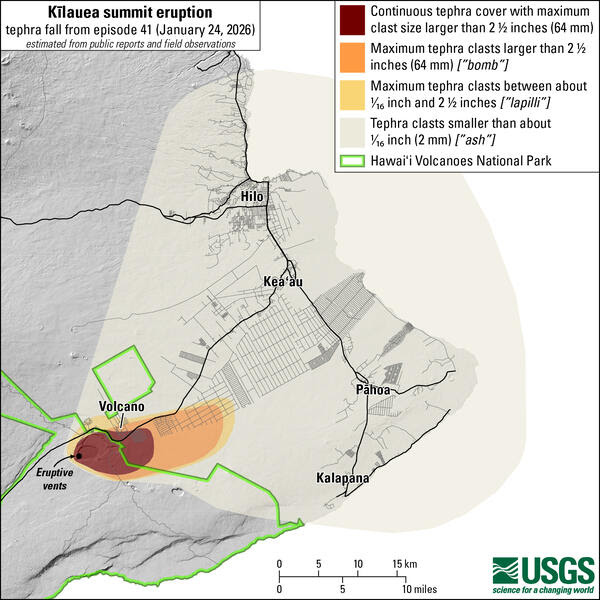
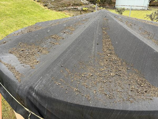
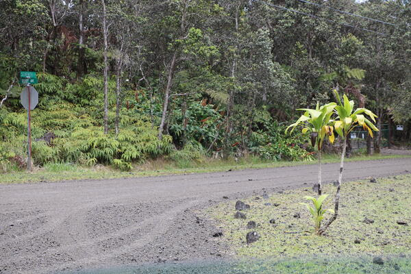
Tephra fallout was densest within 5 miles east-northeast of the vents in Halemaʻumaʻu crater. A thick tephra layer covered the summit region of Hawaiʻi Volcanoes National Park and parts Volcano Village and Maunaloa Estates adjacent to the National Park. The ground in these areas was completely or nearly completely blanketed with pieces of tephra that was so thick in areas that road markings were not visible to drivers.
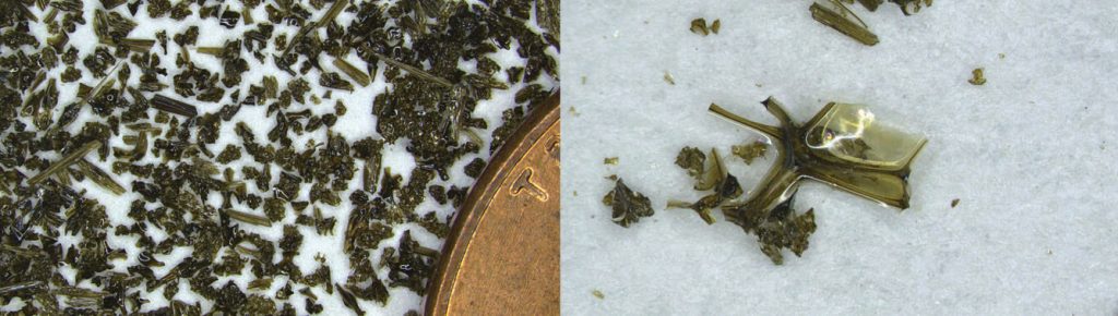
Tephra fragments ranged in size from small strands of Pele’s hair to larger pieces of frothy and lightweight reticulite that were up to a foot in diameter. They cooled quickly as they traveled through the air and many broke or shattered upon impact with hard surfaces. Others drifted down and landed intact on softer surfaces, like grass, while some pieces remain suspended in the branches of trees and ferns.
Farther away, parts of the Volcano Golf Course Community, Ohia Estates, Royal Hawaiian Estates, and Fern Forest received tephra fall ranging from Pele’s hair and ash to pieces of reticulite that were up to several inches (64 mm) in diameter.
Communities even farther away, in the District of Puna and parts of South Hilo, saw light fall or a dusting of fine-grained ash and Pele’s hair, extending from Pepeekeo to Kalapana.
What made this tephra fall pattern from episode 41 so different from earlier episodes?
Several past episodes have had lava fountains reaching similar heights, but never from both vents at the same time. And most past eruptive episodes were erupted during trade wind conditions.
Trade winds blow from northeast to southwest. When there are lava fountaining episodes at the summit of Kīlauea during trade winds, tephra is transported to the southwest. Much of the larger pieces land in the closed area of Hawaiʻi Volcanoes National Park but communities in the District of Kaʻū, including Pāhala, Nāʻālehu, and Ocean View, have experienced ash and Pele’s hair falling on them several times.
During episode 41, there were no trade winds. Winds at the ground level were weak. As the dual high fountains from the north and south vents erupted large volumes of lava, they released an immense amount of heat that rose upwards, lofting tephra ranging in size from fine ash and Pele’s hair to the larger frothy reticulite being formed by the lava fountains. At upper levels, these lightweight clasts encountered stronger winds blowing to the east and northeast, transporting them in that direction.
Tephra landed on Highway 11 as vehicles were driving on it, creating hazardous conditions. The County of Hawaiʻi temporary closed Highway 11 in two locations on either side of the entrance to Hawaiʻi Volcanoes National Park. Within Hawaiʻi Volcanoes National Park, visitors were pelted by falling tephra as rangers temporary closed the public overlooks around the caldera. Episode 41 started at 11:10 a.m. on Jan. 24, and the most intense period of tephra fall happened in the hours immediately after the episode started. Lighter tephra fall continued until the episode ended more than 8 hours later, at 7:26 p.m.
In the days since, clean-up efforts on roadways and roofs have been underway. The County of Hawaiʻi Civil Defense Agency has numerous resources available to residents affected by this episode at: https://hawaii-county-civil-defense-agency-hawaiicountygis.hub.arcgis.com/.
Has a tephra fall event like this happened before in Hawaiʻi?
Yes. In January and March of 2025, lava fountaining episodes in Halemaʻumaʻu deposited Pele’s hair in communities around Kīlauea summit. More than 40 years ago, the Puʻuʻōʻō vent on the East Rift Zone of Kīlauea erupted its 30th episode of lava fountaining on Feb. 4, 1985. Tephra up to several inches in diameter fell in Hawaiian Acres and Pele’s hair fell as far away as Hilo.
What do episodes in January/March 2025, and episode 41 in the ongoing Kīlauea eruption have in common with episode 30 of the Puʻuʻōʻō eruption? They all occurred during the winter months, a time of year when we do not reliably have trade winds in Hawaiʻi.
What is important to remember moving forward? The episodic lava fountaining eruption at the summit of Kīlauea is not over. Episode 42 is forecast to occur between Feb. 9 and 20. A combination of fountaining dynamics and wind conditions determines where tephra fall may occur for any given episode of this eruption.
Volcano Activity Updates
Kīlauea has been erupting episodically within the summit caldera since Dec. 23, 2024. Its USGS Volcano Alert level is WATCH.
Episode 41 lava fountaining happened for just over 8 hours on Jan. 24. Elevated micro-seismicity has continued intermittently in the summit region since the end of episode 40. Summit region inflation since the end of episode 41 indicates that another fountaining episode is possible and could occur between Feb. 9 and 20. No unusual activity has been noted along Kīlauea’s East Rift Zone or Southwest Rift Zone.
Maunaloa is not erupting. Its USGS Volcano Alert Level is at NORMAL.
Three earthquakes were reported felt in the Hawaiian Islands during the past week: a M3.5 earthquake 0 miles N of Pāhala at 18 mile depth on Jan. 28 at 2:52 a.m., a M1.7 earthquake 8 miles S of Volcano at a depth of 18 miles on Jan. 26 at 11:48 p.m., and a M4.2 earthquake 1 mile NW of Pāhala at a 20 mile depth on Jan. 26 at 11:37 p.m.
HVO continues to closely monitor Kīlauea and Maunaloa.
Visit HVO’s website for past Volcano Watch articles, Kīlauea and Maunaloa updates, volcano photos, maps, recent earthquake information, and more. Email questions to askHVO@usgs.gov.
Sponsored Content