

Flood Warning for Big Island through 3:45 p.m.; Flood Watch for Hawaiʻi Island through this afternoon
Flood Warning for Hawaiʻi Island until 3:45 p.m.
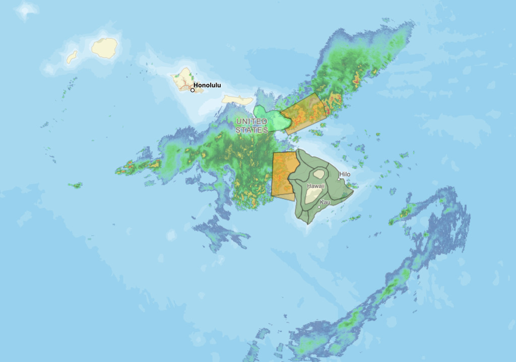
The National Weather Service has issued a Flash Flood Warning for the island of Hawaiʻi until 3:45 p.m. At 1:01 p.m., radar showed an area of very heavy rain over far eastern Big Island between Laupāhoehoe and Mountain View. Rain was falling at a rate of 2 to 4 inches per hour. Hawaii County Civil Defense reported road flooding along Bayfront Highway. Additional areas of heavy rain could develop elsewhere in the warned area over the next few hours. Some locations that will experience flash flooding include: Hilo, Hawaiian Paradise Park, Honokaʻa, Volcano, Glenwood, Mountain View, Hawaiʻi Volcanoes National Park, Hawaiian Acres, Keaʻau, Wood Valley, Pōhakuloa Camp, Pāpaʻikou, Pepeʻekeo, Pāhala, Honomū, Pāhoa and Hakalau.
Flood Advisory extended for Maui until 2 p.m.:
The National Weather Service has extended a Flood Advisory for the island of Maui until 2 p.m. due to excessive rainfall. At 10:48 a.m., radar showed heavy rain over Maui. Rain was falling at a rate of 1 to 2 inches per hour. Some locations that will experience flooding include: Kahului, Kīhei, Lahaina, Kula, Pukalani, Makawao, Kēōkea, Hāliʻimaile, Pāʻia, Puʻunēnē, Haʻikū-Paʻuwela, Wailea, Paʻuwela, Māʻalaea, Huelo, ʻUlupalakua, Mākena, Waikapū, Wailuku and Waiehu.
At 7:58 a.m., radar showed heavy rain over windward locations of Maui, falling at a rate of 1 to 2 inches per hour.
Flood Watch for Big Island through this afternoon
The Big Island remains under a Flood Watch through this afternoon as unstable tropical moisture left from the departing kona low continues to bring the threat of isolated thunderstorms and rainthrough this afternoon. A band of thunderstorms continues to approach the Big Island from the west-southwest direction, which may produce another round of heavy rainfall later today.
Previous posts:
Flood Warning until 1 p.m. for Hawaiʻi Island
The National Weather Service has issued a Flash Flood Warning for the island of Hawaiʻi until 1 p.m. At 10:22 a.m., radar showed heavy rain over Kona and Kohala areas. Rain was falling at a rate of 2 to 3 inches per hour. Flash flooding is ongoing or expected to begin shortly. Flooding in drainages, streams, rivers, roads, properties, and other low-lying areas. Public road closures possible in some areas. Landslides are possible in steep terrain. Some locations that will experience flash flooding include: Kailua-Kona, Captain Cook, Waikōloa Village, Kapaʻau, Puʻuanahulu, Puakō, Kalaoa, Holualoa, Kawaihae, Honalo, Kamuela, Kahaluu-Keauhou, Kohala Ranch, Kainaliu, Kealakekua, Honaunau, Waimanu Valley, Waipiʻo Valley, Pololū Valley and Kukuihaele.
Flood Advisory until 1 p.m. for Hawaiʻi Island
The National Weather Service has issued a Flood Advisory until 1 p.m. for Hawaiʻi Island. At 9:57 a.m., radar showed heavy rain over Kona and Kohala areas. Rain was falling at a rate of 1 to 2 inches per hour. Some locations that will experience flooding include: Kailua-Kona, Captain Cook, Waikōloa Village, Kapaʻau, Puʻuanahulu, Puakō, Kalaoa, Holualoa, Kawaihae, Honalo, Kamuela, Kahaluʻu-Keauhou, Kohala Ranch, Kainaliu, Kealakekua, Honaunau, Waimanu Valley, Waipiʻo Valley, Pololū Valley and Kukuihaele.
Flood Warning for Hawaiʻi Island canceled as of 12:05 p.m.
The National Weather Service has canceled the Flood Warning for the Big Island as of 12:05 p.m. The heavy rain has ended. Flooding is no longer expected to pose a threat. A Flood Watch remains in effect until 6 p.m. for the Big Island.
Strong Thunderstorms to impact Hawaiʻi Island through 10:30 a.m.
The National Weather Service says strong thunderstorms will impact the Big Island through 10:30 a.m. At 9:35 a.m., Doppler radar was tracking a cluster of strong thunderstorms along a line extending from near Hawi to 5 miles southwest of Kahaluʻu-Keauhou. Movement was east at 15 mph, and wind gusts are blowing at up to 50 mph. Locations impacted include: Captain Cook, Puʻuanahulu, Hawī, Mahukona, Honaunau, Kawaihae, Kahaluʻu-Keauhou, Waikoloa Village, Kainaliu, Kealakekua, Honalo, Pololū Valley, Kohala Ranch, Kalaoa, Halaula, Kapaʻau, Waimanu Valley, Puakō, Kailua-Kona, and Holualoa.
Sponsored Content


