

UPDATE: 5 p.m. 10/15/14, Tropical Storm Watch Issued for Hawaiʻi County
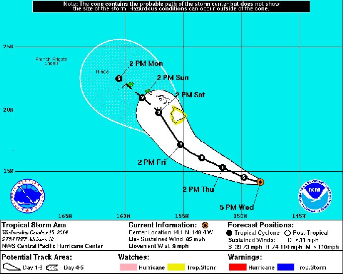
5-day forecast track for Tropical Storm Ana as of 5 p.m. on Wednesday, Oct. 15, 2014. Image courtesy NOAA/NWS/Central Pacific Hurricane Center.
By Malika Dudley
***A new update as of 11 p.m. on Wednesday, Oct. 15, 2014 is now available at the following LINK.
The Central Pacific Hurricane Center released their 5 p.m. update on the current status of Tropical Storm Ana and its potential effects in Hawaiʻi.
A TROPICAL STORM WATCH has been issued for the island of HAWAII. A tropical storm watch means tropical storm conditions are possible within the watch area within 48 hours.
Current Situation:
Tropical Storm Ana was last located near 14.1 N and 148.4 W, about 580 miles SE of Hilo, Hawaiʻi; 705 miles SE of Kahului, Maui; 755 miles SE of Kaunakakai, Molokaʻi; 725 miles SE of Lānaʻi City; and 800 miles SE of Honolulu, Oʻahu on Wednesday, Oct. 15, 2014.
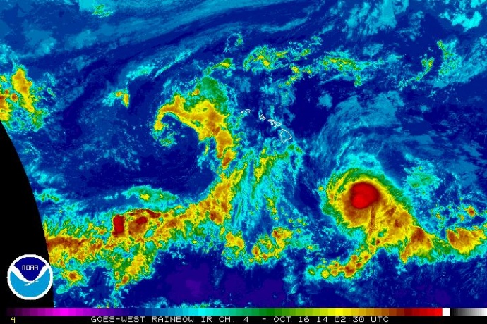
Satellite imagery, 4:30 p.m. HST, Wednesday, Oct. 15, 2014, courtesy NOAA/NWS.
The system has maximum sustained winds of 65 mph, gusting to 75 mph with tropical storm force winds extending 65 miles from the center of the storm. Ana is moving toward the west at 9 mph and is expected to gradually strengthen peaking in intensity at 80 mph sometime on Friday.
On satellite imagery Ana’s structure has taken a bit of a hit and appears less organized and more ragged. Models are indicating sea surface temperatures are warm enough to continue to fuel the storm and wind shear conditions are favorable for further intensification of the system over the next 48 hours. On the other hand, several other models are no longer forecasting Ana to become a hurricane.
A NASA Gulfstream jet collected data this afternoon from the surrounding atmosphere around the system and we should have a better understanding of the system for the next update.
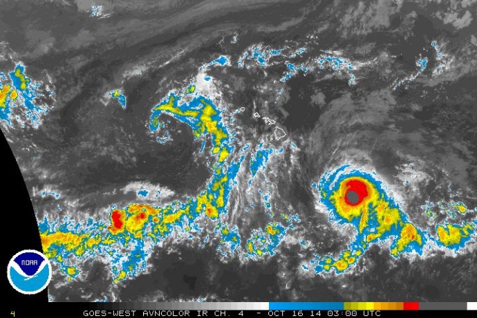
Satellite imagery, 5 p.m. HST, Wednesday, Oct. 15, 2014, courtesy NOAA/NWS.
Forecast & Uncertainty:
Forecasters with the National Weather Service say they are leaning toward the models that indicate Ana is forecast to strengthen through Friday, becoming a hurricane by Thursday. The track has been nudged farther south with regards to the Big Island before jogging northwest tonight or early Thursday.
At this point, the agency says Ana is forecast to moves through much of the Hawaiian Islands as a tropical storm.
Keep in mind this is not an exact science, the system has a 66% chance of falling within the cone of uncertainty. The margin of error still averages about 150 miles for day 4 and 200 miles for day 5. As the storm continues to approach the forecast will become more certain.
Potential Impacts:
Heavy rain may reach the Big Island late Friday potentially causing dangerous flash flooding and mud slides.
Large dangerous surf conditions are expected to begin impacting the eastern end of the Hawaiian islands late Thursday. In the best case scenario ANA goes well south and is nothing but a high surf event. The worst case scenario is landfall which could bring flooding rains, extreme winds, storm surge and coastal flooding.
Sponsored Content


