

UPDATE: 5 a.m., 10/16/14, Ana Getting Closer, Hurricane by Friday
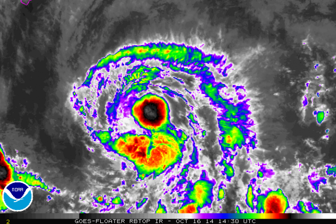
Satellite imagery for Tropical Storm Ana as of 5 a.m. on Thursday, Oct. 16, 2014. Image courtesy NOAA/NWS/Central Pacific Hurricane Center.
By Meteorologist Malika Dudley
***An update as of 11 a.m. on 10/16/14 is now posted at the following LINK.
The latest update on Tropical Storm ANA was just released by the Central Pacific Hurricane Center. Not much change in intensity or forecast track. ANA is getting closer and expected to intensify over the next 24 to 36 hours to hurricane status.
Summary of Alerts:
HURRICANE WARNING – All Hawaiian Offshore Waters / Starting Friday AM
TROPICAL STORM WARNING – All Hawaiian Offshore Waters / Starting Thursday PM
TROPICAL STORM WATCH – Hawaiʻi County / In effect
FLASH FLOOD WATCH – Hawaiʻi County / Friday at noon to Sunday at 6 p.m.

5-day forecast track for Tropical Storm Ana as of 5 a.m. on Thursday, Oct. 16, 2014. Image courtesy NOAA/NWS/Central Pacific Hurricane Center.
Current Situation (5AM UPDATE):
Tropical Storm with 60 mph Maximum Sustained Winds, Gusting to 70 mph
Tropical storm force winds extend 60 miles from the center
Moving W at 10 mph
Tropical Storm Ana was last located near 14.1 N and 150.3 W, about 495 miles SE of Hilo, Hawaiʻi; 620 miles SE of Kahului, Maui; 665 miles SE of Kaunakakai, Molokaʻi; 635 miles SE of Lānaʻi City; and 705 miles SE of Honolulu, Oʻahu on Thursday, Oct. 17, 2014 at 5 a.m.
ANA was looking ragged last night but the outflow pattern is improving which tells us that shear is not affecting the storm right now as much as it was yesterday. Satellite imagery is showing a storm that’s pretty torn up but a burst of deep convection is present near the center of the storm this morning.
The Central Pacific Hurricane Center is indicating that the intensity forecast is quite tricky with this storm. Sea surface temperatures are more than sufficient to fuel ANA and vertical wind shear is expected to decrease so further intensification is the likely result of that. However, some models are still indicating that ANA will not become a hurricane. The current intensity forecast takes all models into account. Gradual intensification is expected over the next 24 to 36 hours.

Satellite imagery for Tropical Storm Ana as of 5 a.m. on Thursday, Oct. 16, 2014. Image courtesy NOAA/NWS/Central Pacific Hurricane Center.
Forecast & Uncertainty:
The current track has not changed much with ANA passing 75 miles south and west of the island of Hawaiʻi Friday night and Saturday, passing Maui County Saturday into Sunday and nearing Oʻahu and Kauaʻi over the weekend and into Monday.
The probability of tropical storm conditions over Big Island leeward and southeast coastal waters is 71%; 36% in Hilo; 51% in Kailua-Kona and 62% near South Point.
Remember, these systems are notoriously difficult to predict and the center of the storm has a 66% chance of landing anywhere within the cone of uncertainty. The margin of error going out 48 hours is still a whopping 80 miles. Even small shifts in the track can mean major differences in where the worst conditions will occur. Damaging effects can extend far from the center so it’s important that residents prepare just in case.

5-day forecast track and Satellite imagery for Tropical Storm Ana as of 5 a.m. on Thursday, Oct. 16, 2014. Image courtesy NOAA/NWS/Central Pacific Hurricane Center.
Potential Impacts (if the track holds):
Heavy rain may reach the Big Island late Friday potentially causing dangerous flash flooding with excessive runoff causing possible mud slides and rock slides.
Large dangerous surf conditions are expected to begin impacting the eastern end of the Hawaiian islands late Thursday.
Big Island –
10 to 15 inches with locally up to 20 inches along southeast facing slopes beginning Friday afternoon.
Winds of 25 to 40mph, gusting to 60 mph are possible Friday/Saturday
Seas of 20 to 30 feet are expected late Friday along the Puna & Kaʻū coastlines during the closest approach / peaking Friday night
Maui County –
Winds of 35 – 50 mph winds are possible Saturday through Monday
Locally heavy rainfall, frequent scattered showers, thunderstorms possible Friday
Tropical Storm conditions possible Saturday / Sunday
Kauaʻi & Oʻahu –
Tropical Storm conditions possible Saturday / Sunday
Locally heavy rainfall, frequent scattered showers, thunderstorms possible Saturday / Sunday
Winds of 25 to 40 mph Saturday / Sunday, increasing to 35 to 50 mph Monday
Sponsored Content


