

11pm ANA Update: 10/17/14, Tropical Storm Conditions Unlikely
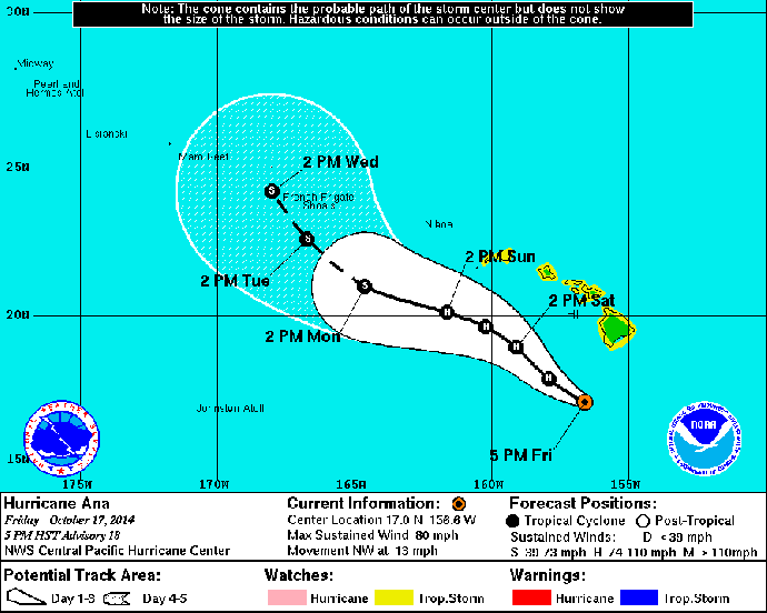
5-day forecast track, 11 p.m. HST, Friday, Oct. 17, 2014, courtesy NOAA/NWS.
By Meteorologist Malika Dudley
The Central Pacific Hurricane Center has just released their 11 p.m. update on Hurricane ANA. There are no new alerts for Maui County. The intensity of the storm has increased a bit since the last update and the track still brings ANA south of the islands through the forecast period. The chance of tropical storm conditions has greatly diminished and hurricane conditions are not likely. The center of ANA is 225 miles S of Kahului, 230 miles S of Kaunakakai and 210 miles S of Lānaʻi City at 11 p.m. on Friday Oct. 17, 2014.
Summary of Alerts:
FLASH FLOOD ADVISORY – Island of Hawaiʻi through 1:30am
HURRICANE WARNING – All Hawaiian Offshore Waters
TROPICAL STORM WARNING – All Hawaiian Offshore Waters / Big Island leeward coastal waters and Big Island southeast waters
TROPICAL STORM WATCH – Statewide / All coastal waters
Current Situation:
Hurricane – Category 1
85 mph maximum sustained winds, gusting to 104 mph
Moving NW at 13 mph
Hurricane force winds extend outward 25 miles, tropical storm force winds extend 115 miles.
A decrease in forward speed is expected Saturday night and Sunday with a turn toward the west. If the track does not change ANA is expected to pass 150 miles southwest of the Big Island tonight and 175 miles southwest of the rest of the islands over the weekend. ANA is expected to maintain hurricane status through Saturday and slowly weaken Sunday.
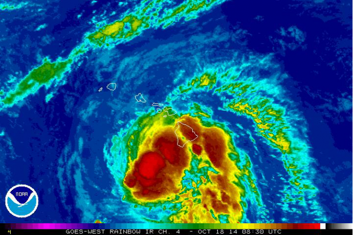
Satellite imagery, 11 p.m. HST, Friday, Oct. 17, 2014, courtesy NOAA/NWS.
Possible impacts to Maui County:
Increased showers and periods of gusty winds are apparent for the windward side of Maui at 9:15pm. Highest gusts today: Molokaʻi – 39 mph / Kahului – 36 mph / Lānaʻi City – 30 mph
Chance of tropical storm conditions is 30 – 40% for leeward waters, 8% for Kahului, 11% for Lanai and at 11% for Kaunakakai.
Timing: We expect to start seeing some effects, mainly surf and rain, later tonight and into Saturday morning. Conditions will gradually deteriorate. Tropical storm conditions are possible Saturday into Sunday. Maui County could be under the effects of ANA for about 24 hours.
Wind: For Haleakalā wind predictions are at 35 – 45 mph, gusting to 60 mph. Lower elevations of all islands are not expected to get winds above 39 mph at this time however there is still a small chance that could occur. Winds of 20 – 30 mph winds, gusting to 35 mph are possible Saturday afternoon & evening with the strongest winds on the southwest side of Maui County, particularly Lānaʻi and Molokaʻi.
Rain: Rainfall of 2 to 8 inches is possible across Maui County. Higher amounts are expected for mountainous terrain and along slopes where there is lift.
Surf: Ana will produce warning level surf of 10-15 ft along south facing shores Saturday and remain elevated through Sunday.
Seas: Ana is expected to produce winds at 30 to 40 mph and seas up to 20 ft across leeward coastal waters Saturday through Sunday. An incoming northwest swell combined with strengthening winds will produce hazardous seas across the remainder of the coastal waters Saturday night and Sunday.
Sponsored Content


