Swell Fills in Today, XXL Swell Builds Overnight
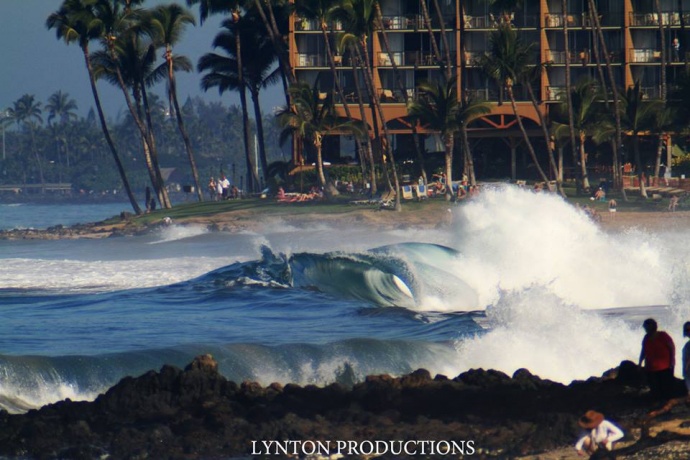
Taken 1/19/15 – Image: Aaron Lynton
By Meteorologist Malika Dudley / Email: [email protected]
Alerts
A Marine Weather Statement has been issued by the National Weather Service for a very large west-northwest swell. The Weather Service in Honolulu says a rapidly building swell will arrive tonight and remain elevated into Thursday. They are warning of strong harbor surges and large breaking waves at harbor entrances exposed to the swell. Some locations that can expect such conditions are Kaumalapau harbor on Lāna’i.
A High Surf Warning has been issued for the north and west shores of Moloka’i and the north shore of Maui. The warning goes into effect this evening at 6:00 p.m. and is posted through Thursday at 6:00 p.m. Wave heights of 30 to 40 foot faces are expected along the north shores while 15 to 25 foot faces are expected on the west side of Moloka’i. Expect ocean water occasionally sweeping across portions of beaches, very strong breaking waves and strong longshore and rip currents. Breaking waves may occasionally impact harbors making navigating the harbor channel difficult. Large breaking surf, significant shore break and dangerous currents will make entering the water very hazardous. Boaters should be aware of an increased number of surfers in the water.
A High Surf Advisory has been issued for the west shores of Maui, Lāna’i and Kaho’olawe from 6:00 p.m. tonight through 6:00 p.m. Thursday. Wave heights from 12 to 15 feet are expected on Maui. Surf heights of 6 to 10 feet are expected for Lāna’i and Kaho’olawe. Expect strong breaking waves, shore break and strong longshore and rip currents making swimming difficult and dangerous.
A Small Craft Advisory has been issued for all island waters from 6:00 p.m. tonight through 6:00 p.m. Thursday for southwest winds from 10 to 20 knots and rough seas of 8 to 18 feet.
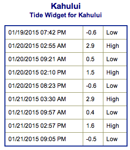
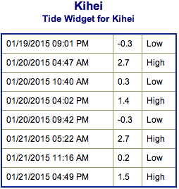
**Click directly on the images below to make them larger. Charts include: Maui County projected winds, forecasted swell direction, height & period, tides, a surface map and expected wave heights.**
 Maui County Surf Forecast, Tuesday, January 20, 2015
North: Surf heights are expected chest high to head high. The best breaks, especially spots east of Ho’okipa, will be slightly bigger. Waves build overnight.
West: Some spots will catch wrap from the west-northwest swell. West Maui spots with a northerly exposure should see knee to waist high waves. Otherwise, breaks that don’t catch the swells, and / or are shadowed from them, are forecasted to get smaller surf at ankle high or flat.
South: Under waist high surf is expected. Most spots are flat.
A west-northwest / northwest swell is expected to fill in Tuesday as our current swell continues to fade.
 Models are predicting a much larger west-northwest swell arriving around the middle of next week, producing surf well above warning levels. This XXL swell (285-315°) is forecasted to move in Tuesday night and peak Wednesday afternoon. If it behaves as models are indicating we could see an occasional 30+ foot face at the peak of this event (although inconsistent). If so, it would be the largest swell thus far this season.
A reinforcement is expected to move in Friday and begin to fade out on Sunday. Pending development we could see another solid west-northwest swell setting up for Tuesday and Wednesday of next week.
Small south-southwest brings knee to possibly waist high waves at the best breaks.
Keep in mind, surf heights are measured on the face of the wave from trough to crest. Heights vary from beach to beach, and at the same beach, from break to break.
**Click here for your detailed Maui County weather report.**
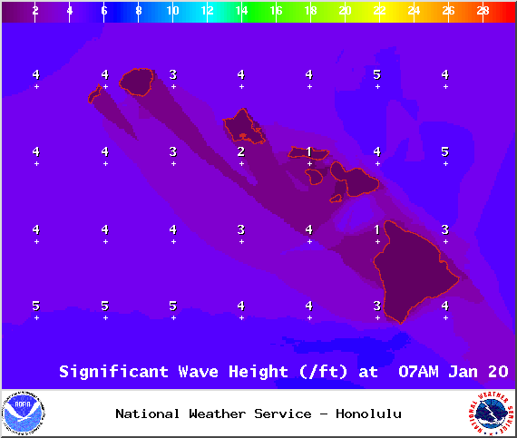
Image: NOAA / NWS
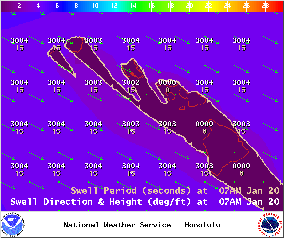
Image: NOAA / NWS
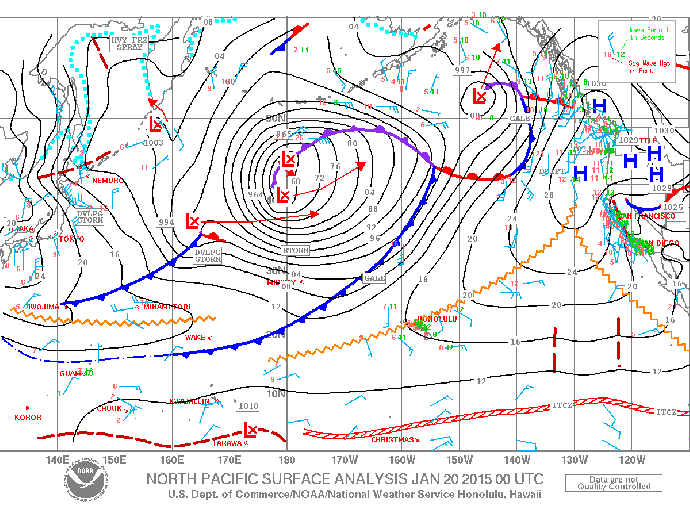
Image: NOAA / NWS
Image: NOAA / NWS
Image: NOAA / NWS
Sponsored Content