Hilda Now Category 2 Hurricane
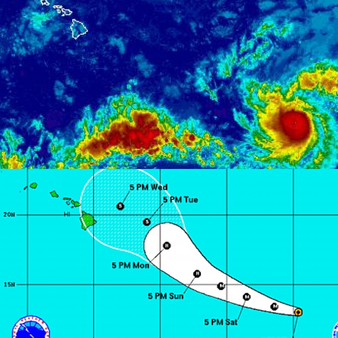
Image: NWS / NHC satellite and track – Hilda 5 p.m. August 7
By Meteorologist Malika Dudley / Email: malika@mauinow.com
(Updated at 5 p.m.)
Hilda has quickly intensified into a Category 2 hurricane. Maximum sustained winds are now at 105 mph with higher gusts. Additional strengthening is forecasted over the next 12 to 24 hours with a weakening trend to start on Sunday.
The storm, located 1230 miles ESE of Kahului, 1290 miles ESE of Kaunakakai and 1265 miles ESE of Lanai City, continues to move W at 15 mph. A gradual turn to the west-northwest is expected over the next 48 hours.
Hilda is still quite compact and small. Hurricane force winds extend just 15 miles from the center and tropical storm force winds extend outward up to 70 miles.
(Updated at 11 a.m.)
Hilda has quickly intensified over the last few hours and now has maximum sustained winds of 80 mph making it a Category 1 hurricane. Additional strengthening is forecasted over the next 48 hours.
The storm, located 1325 miles ESE of Kahului, 1370 miles ESE of Kaunakakai and 1345 miles ESE of Lanai City. The system continues to move W at 15 mph. This motion should continue through this afternoon before the system veers west-northwest later today or tomorrow.
Hilda is still quite compact and small. Hurricane force winds extend just 10 miles from the center and tropical storm force winds extend outward up to 70 miles.
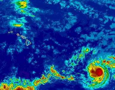
Image: NWS Satellite Hilda 11 a.m.
FORECAST SUMMARY – The center of weakening post-tropical low Guillermo is moving west-northwest near 16 mph. A moist and unstable air mass will linger over the islands today, fueling locally heavy downpours, and bringing a slight chance of thunderstorms.
Trade winds will strengthen tonight and remain locally gusty through the weekend, delivering brief windward showers that favor nights and mornings. Trade wind speeds will ease early next week, with tropical cyclone Hilda potentially nearing the islands by the middle of next week. What effects, if any, Hilda will have on our weather are entirely dependent on the track the system takes as it nears the islands.

Image: NWS Guillermo and Hilda (bottom right) 5 a.m.
(Updated at 5 a.m.)
As of 5:00 a.m. this morning, the Central Pacific Hurricane Center has issued it’s last advisory for Guillermo. The system has winds at 35 mph and is moving rapidly west-northwest at 17 mph and away. Gradual weakening is expected through dissipation on Saturday. Guillermo is currently located 325 miles NW of Hilo, 280 miles NW of Kailua-Kona and 335 miles NW of South Point.
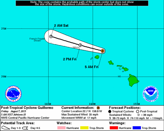
Image: CPHC Guillermo track 5 a.m.
Meanwhile, Hilda is still spinning in the Eastern Pacific at tropical storm strength. The compact system maintained maximum sustained winds of 60 mph overnight but became a little bit bigger with tropical storm force winds now extending 70 miles from the center.
Hilda is currently located 1300 miles ESE of Hilo, 1370 miles ESE of Kailua-Kona
and 1335 miles ESE of South Point. The system is moving W at 13 mph. This general motion should continue through today with a gradual turn to the WNW tonight or Saturday.
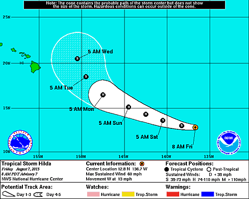
Image: NHC Hilda track 5 a.m.
The eventual forecast track has the system veering NW – just how much will depend on many factors moving forward. We will continue to watch this and bring you the latest. Hilda is expected to reach hurricane status this evening or tomorrow as well.
Sponsored Content