XXL Swell Peaks and Slowly Trends Down

Image: Tad Craig
Alerts (as of 1:00 a.m.)
A Small Craft Advisory is in effect for all Maui County windward waters and most channels through 6 a.m. Friday.
A High Surf Warning is posted for the north and west sides of Molokai and the north shore of Maui through 6 p.m. Thursday.
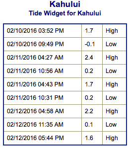
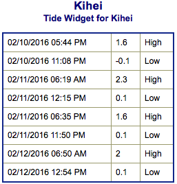
**Click directly on the images below to make them larger. Charts include: Maui County projected winds, tides, swell direction & period and expected wave heights.**
 Maui Surf Forecast
North: Wave heights are slowly trending down all day with surf expected to be 25 to 35 foot faces with 40 to 45 foot faces at the best spots in the morning.
West: Wrap from the northwest swell affecting some western shores today will slowly fade although most spots are still washed out. Spots with northern exposure could get upwards of 25 foot faces.
South: Wave heights are waist high or less today out of the south-southwest.
 An XXL swell is expected to peak early Thursday and slowly trend down thereafter. Surf on the smaller islands is at warning levels. Deep water breaks should see elevated wave heights with most spots being washed out. Standout breaks like Pe’ahi “Jaws” could even get up to 50 foot faces in the morning.
A good sized west-northwest is due in late on Valentine’s Day.
Our current southwest swell continues to slowly fade Thursday. A small new south-southwest is expected Friday and Saturday.
Keep in mind, surf heights are measured on the face of the wave from trough to crest. Heights vary from beach to beach, and at the same beach, from break to break.
**Click here for your detailed Maui County weather report.**
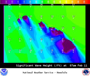
Image: NOAA / NWS
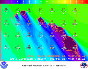
Image: NOAA / NWS
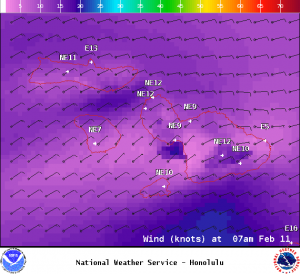
Image: NOAA / NWS
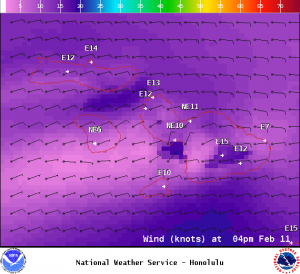
Image: NOAA / NWS
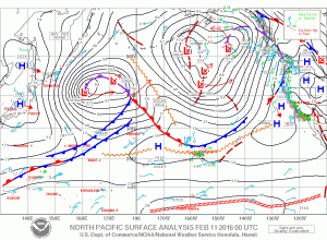
Image: NOAA / NWS
Sponsored Content