

Tallest, Hottest Lava Activity of Eruption to Date
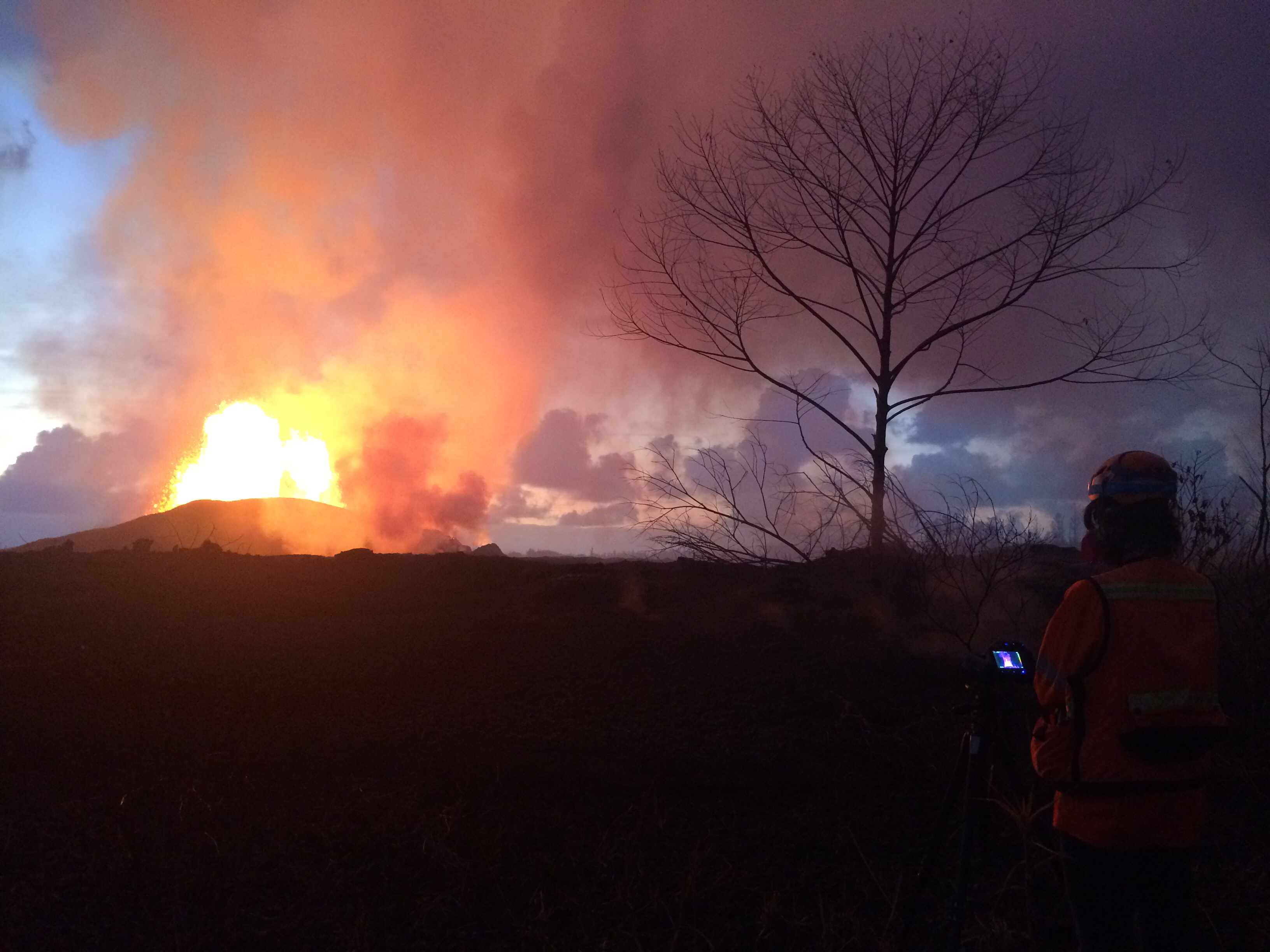
Crews make visual observations of activity at fissure 8 around 5:30 a.m. HST. Fountain heights this morning continue to reach 70 to 80 m (230 to 260 ft) above ground level. The fountaining feeds a lava flow that is moving to the northeast along Highway 132 into the area of Noni Farms road. PC: US Geological Survey 5.31.18
Scientists are saying the lava coming from the fountaining activity in the East Rift Zone is the tallest and hottest they’ve seen during the current eruption.
Fountain heights of 250 feet were recorded at Fissure 8 on Wednesday night, with magma temperatures recorded at around 900°C or 1652°F.
“This is the hottest lava that we’ve seen in this eruption,” said Wendy Stovall, geologist/volcanologist with the USGS Hawaiʻi Volcanoes Observatory. She said the molten material coming into the system is “hot, gas rich magma” from deep inside the earth.
Material from Fissure 8 was moving downhill into the area of Noni Farms road at last report at a rate of 50 yards per hour. That’s slower than yesterday, according to HVO officials.
Other activity on the radar includes lava from Fissure 18, which was a half-mile from Highway 137, and had seemed to slow down from yesterday. Low-level spattering was also reported at Fissure 21. There’s also two smaller fountains adjacent to Fissure 8 and a cinder cone in the area.
Summit activity continues today with some minor ash explosions. HVO officials report that seizmicity is slightly slower over last 24 hours.
HVO scientists say the caldera of Kīlauea was formed in the 1500s. “There was a period of 300 years of much more explosive summit activity (than what we are seeing now). Over that period the caldera formed.” According to Stovall, Halemaʻumaʻu was first observed and documented as an active lava lake in 1823. At the time, the crater itself was much smaller than what it is today. The lava lake drained away at 1924, and after that, Halemaʻumaʻu grew in size. Today we see an overlook vent that has “nearly doubled in size,” according to Stovall, taking up a good portion of the eastern half of the crater.
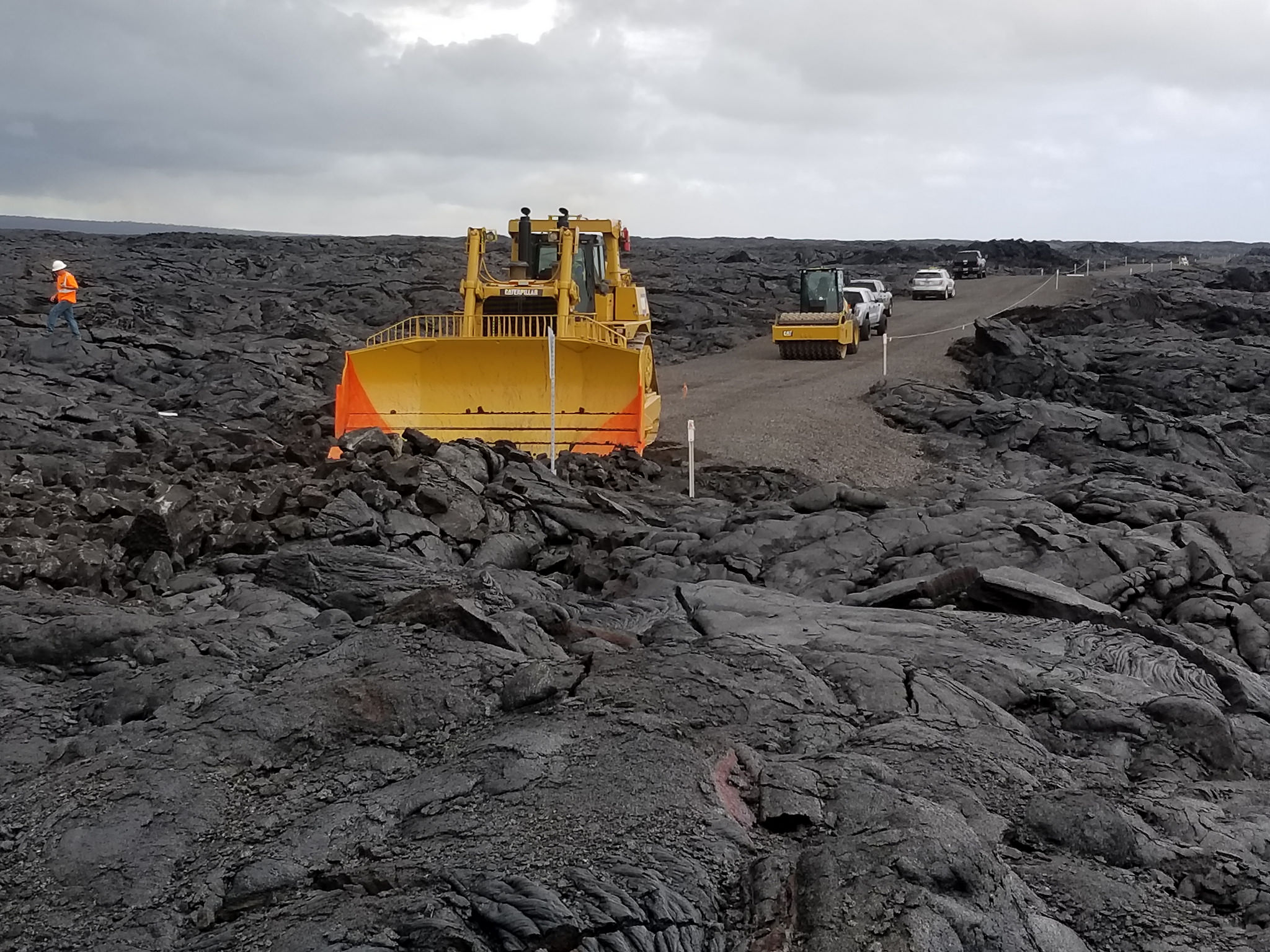
First bulldozer touches hard lava on Chain of Craters-Kalapana Road
NPS Photo/M.Theune.
Hawaii Volcanoes National Park:
Work on Evacuation Route Underway, No Layoffs, Flight Restrictions Extended
During a daily briefing, Jessica Ferracane, a public information officer with the Hawaiʻi Volcanoes National Park said work continues on chain of craters as an evacuation route. Crews have gotten through 1,600 feet of hardened lava. Ferracane says that’s about half of what they need to do, and crews could possibly complete work by this weekend.
According to National Park officials, “The eight-mile section (Chain of Craters-Kalapana Road) along the coast that once connected the park to Kalapana has been closed for years, but was recently reconstructed as an evacuation route in 2014. It was covered in lava in 2016 and 2017. Opened in 1965, the road has been blocked by lava for 41 of its 53-year-existence.”
Work began May 30 to remove a 0.7-mile-wide section of solidified lava from the now-defunct 2016-2017 61g lava flow that covered the emergency road. Rough grading and other reconstruction efforts are currently underway to make the eight-mile length of road passable.
When finished, the road will serve as a one way out path, not an ongoing thoroughfare, according to Ferracane.
Ferracane also addressed a rumor about layoffs at the park saying, “There are no layoffs. I want to make that very clear. We have 134 people working for Hawaiʻi Volcanoes National Park.” Despite an extended closure, many employees are working remotely and all remain employed.
A temporary flight restriction has also been extended to Aug. 31 to 30,000 feet above sea level, extending out in a five mile radius, according to Ferracane.
Below are some video highlights provided by the USGS:
Scientists from the US Geological Survey’s Hawaiian Volcano Observatory are part of a 24 hour watch during the ongoing eruption on the lower east rift zone of the Kīlauea Volcano. Working in shifts they keep an eye on where the lava activity is and where it might move to.
A UAS (Unmanned Aircraft Systems) mission during this past week documented the widening of the Overlook vent. Earthquakes in the Kīlauea Volcano’s summit region continue as the area subsides and adjusts to the withdrawal of magma.
The vent is widening due to the collapse of the steep enclosing walls and rim. Large rockfalls from these areas have triggered explosive events that produce minor amounts of ashfall downwind. The video surveys the southeast rim of the Overlook vent to the old Overlook parking lot, showing cracks in the rim and areas dusted with ash.
Limited UAS flights into this hazardous area are conducted with permission and coordination with Hawai‘i Volcanoes National Park. The information is used to quantify change and informs assessment of hazards, which is shared with the National Park Service and emergency managers. Footage is courtesy of the US Department of the Interior Office of Aviation Services.
Sponsored Content


