

Record-Breaking Storm Could Bring Pe’ahi Swell
By Meteorologist Malika Dudley / Email: malika@mauinow.com
Former super typhoon Nuri is making history. After becoming extra-tropical and merging with a frontal system the storm is now the strongest non-tropical storm ever recorded in the North Pacific.
The system is expected to bring us a solid northwest swell (310-335°) building through Veteran’s day, peaking late and into Wednesday with 15 to 25 foot faces possible at the best exposures. Deep water, big wave spots could possibly even see bigger waves.
**Click on the surf and wind chart images below to make them larger.**
Today’s Alerts
A HIGH SURF ADVISORY has been issued by the National Weather Service for the north facing shores of Molokaʻi and Maui until 6 p.m.
Expect strong breaking waves, shore break and strong currents making swimming difficult and dangerous. Anyone entering the water could face significant injury due to the dangerous hazards this swell will pose. Boaters are asked to be aware of the increased number of surfers likely to be in the water.
A SMALL CRAFT ADVISORY is also posted for all waters surrounding Maui County through 6 p.m. North to northeast winds of 25 knots are expected with rough seas up to 15 feet. Inexperienced mariners should avoid navigating in these conditions.
Surf Report
North: Surf is expected double overhead and maybe bigger at most spots exposed to the swell. Best breaks could be triple overhead or even larger.
West: Breaks that don’t catch the swells are forecasted to get smaller surf at ankle high or less. Spots that are open to the north-northwest swell will get some wrap with waves expected head high and possibly larger at the best breaks.
South: Ankle-slappers to possibly thigh high surf is expected.
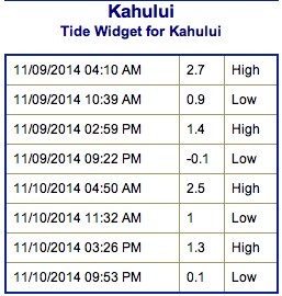 Our current north-northwest swell (320-345°) is peaking into this morning at double to triple overhead on the sets at the best breaks. That’s 15 to 20 foot faces. The swell will gradually fade but still offer overhead to possibly double overhead wave heights through tomorrow morning, easing to head high by sundown.
Former Super Typhoon Nuri is expected to start building Tuesday peaking at triple to maybe even four times overhead on the sets.
If the storms develop, we may also get a series of solid northwest swells Thursday through the weekend.
 Small swells generated in the South Pacific are expected to bring us waves in the thigh high or less range. You might see possible pluses at the best tides and exposures but they will be inconsistent at best and most west side spots will remain flat since they lie in the shadow of other islands.
There isn’t much on the horizon out of the South Pacific.
Keep in mind, surf heights are measured on the face of the wave from trough to crest. Heights vary from beach to beach, and at the same beach, from break to break.
**Click here for Malika’s full Maui County weather report.**

Expected winds at 7am – Image: NOAA / NWS

Expected winds at 4pm – Image: NOAA / NWS

Expected swell height at 7am – Image: NOAA / NWS
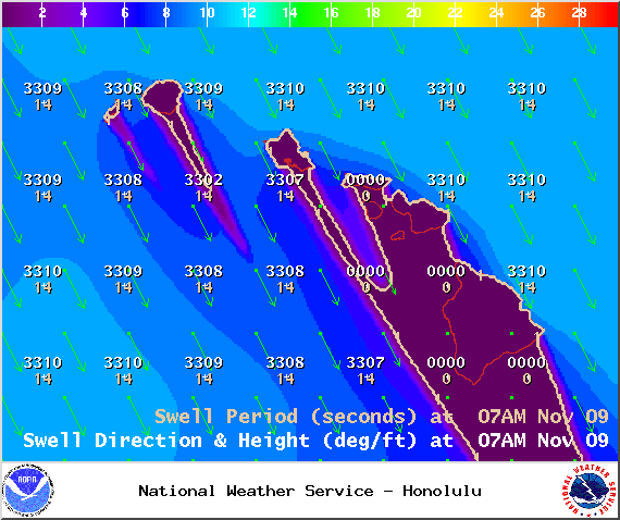
Swell 1 at 7am – Image: NOAA / NWS

Swell 2 at 7am – Image: NOAA / NWS
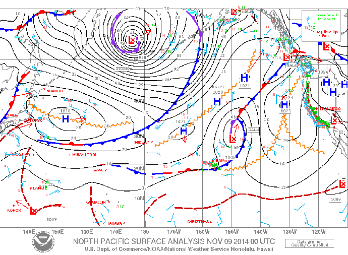
Surface Map – Image: NOAA / NWS
Kihei Rainbow / Image: Krissy Millar
Sponsored Content


