

Peʻahi Swell Peaks This Morning, High Surf Warning Extended
 By Meteorologist Malika Dudley / Email: malika@mauinow.com
Alerts
The National Weather Service has extended the HIGH SURF WARNING through 6 p.m. Wednesday evening for surf increasing to 20 – 30 feet for the north shores of Molokaʻi and Maui. The west side of Molokaʻi is expected to be impacted by 12 – 20 foot waves.
Expect ocean water occasionally sweeping across portions of beaches, very strong breaking waves and strong longshore and rip currents. Breaking waves may occasionally impact harbors making navigating the harbor channel difficult. Large breaking surf, significant shore break and dangerous currents will make entering the water very hazardous. Boaters should be aware of an increased number of surfers in the water.
The SMALL CRAFT ADVISORY has also been extended for the windward waters of Maui and Molokaʻi and the Kaiwi channel through 6 p.m. Wednesday. Rough seas up to 13 feet are expected.
This swell will create hazardous conditions for smaller vessels. Inexperienced mariners should avoid navigating in these conditions.
**Click directly on the images below to make them larger. Charts include: Maui County projected winds, forecasted swell direction, height & period, tides, a surface map and expected wave heights.**
 Maui County Surf Forecast
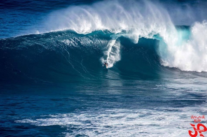
North: Surf is expected to hold/peak this morning at a solid 15 – 25 feet as measured by the face of the wave. Stand out breaks could see sets at 30 feet early on.
West: Breaks that don’t catch the swells are forecasted to get smaller surf at ankle high or less. Spots that are open to the north-northwest swell will get some wrap with waves expected overhead to well overhead at the best breaks.
South: Ankle-slappers to knee high surf is expected.
Former super typhoon Nuri made history. After becoming extratropical and merging with a frontal system a couple of days ago, the storm became the strongest non-tropical storm ever recorded in the NPAC.
 Though it’s not a giant XXL swell, the system is bringing us a solid large northwest swell (310-335°) peaking / holding this morning with 15 to 25 foot faces. The best exposures could see waves up to 30 foot faces. This swell is expected to gradually fade and there will be plenty of solid waves over the next couple days even as it eases.
A series of northwest and north-northwest swells is expected to bring swell energy through the weekend with a couple of reinforcing swells showing up on models for early next week as well.
Small leftovers are expected to bring us waves in the thigh high or less range and gradually continue to fade through the week.
There isn’t much on the horizon out of the South Pacific.
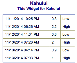
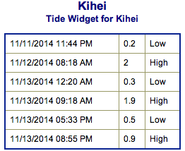
Keep in mind, surf heights are measured on the face of the wave from trough to crest. Heights vary from beach to beach, and at the same beach, from break to break.
**Click here for Malika’s full Maui County weather report.**
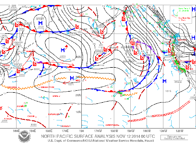
Image: NOAA / NWS
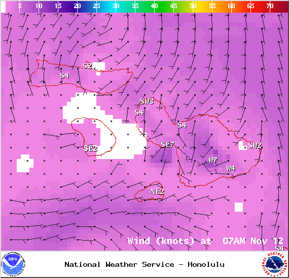
Image: NOAA / NWS
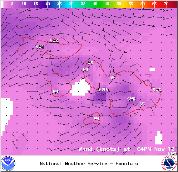
Image: NOAA / NWS
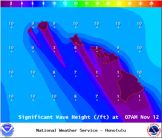
Image: NOAA / NWS
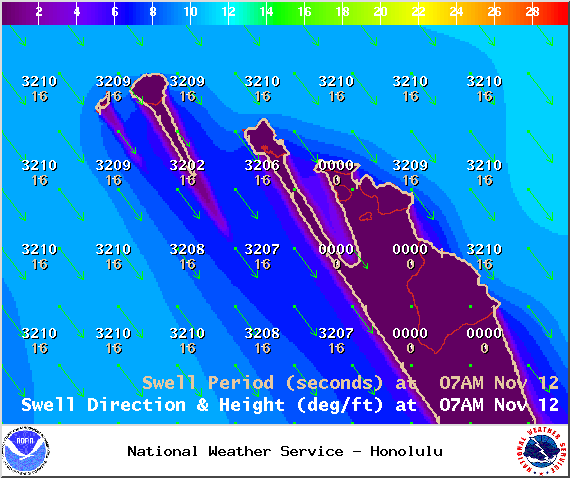
Image: NOAA / NWS
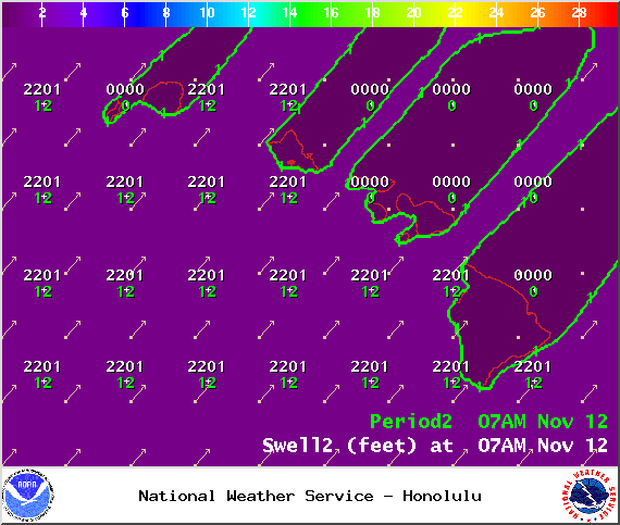
Image: NOAA / NWS
Sponsored Content


