

Swell Fades Today, Large Swell Expected Midweek
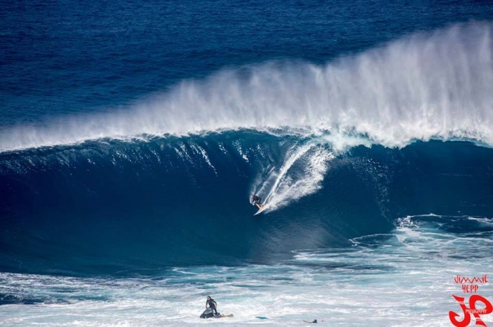
Pe’ahi “Jaws” 1.22.15 / Image: Jimmie Hepp
By Meteorologist Malika Dudley / Email: malika@mauinow.com
Alerts
A High Surf Advisory is posted for the north shores of Maui and Moloka’i through 4:00 a.m. Monday. And for the west side of Moloka’i. Wave heights from 8 to 12 feet are expected for Moloka’i’s west side. Surf heights of 10 to 15 feet are expected for north shores. Expect strong breaking waves, shore break and strong longshore and rip currents making swimming difficult and dangerous.
A Small Craft Advisory has been issued for all island waters through 6:00 a.m. Monday for winds up to 25 knots and rough seas up to 14 feet. For the Pailolo and ʻAlenuihāhā channels, as well as Māʻalaea Bay we expect 20 to 30 knot winds and rough seas up to 14 feet through 6:00 p.m. Monday.
**Click directly on the images below to make them larger. Charts include: Maui County projected winds, forecasted swell direction, height & period, tides, a surface map and expected wave heights.**
 Maui County Surf Forecast
North: Surf heights are expected overhead to possibly double overhead today. The best breaks, especially spots east of Ho’okipa, could see larger waves on the sets, especially early on.
West: Select spots will catch some wrap to about waist high on the sets. Otherwise, breaks that don’t catch the swells, and / or are shadowed from them, are forecasted to get smaller surf at ankle high or flat.
South: Wrap from the west-northwest for select breaks could be up to waist high. Otherwise, waves should be ankle to knee high.
Our current swell is expected to continue to fade through Tuesday.
 A new storm has developed off of Japan, so we could see another solid west-northwest swell setting up for Wednesday of next week. This swell is expected to build late Tuesday and peak on Wednesday with well overhead surf expected. The best breaks could see double to triple overhead waves at the peak of the swell.
Nothing exciting out of the SPAC.
Keep in mind, surf heights are measured on the face of the wave from trough to crest. Heights vary from beach to beach, and at the same beach, from break to break.
**Click here for your detailed Maui County weather report.**
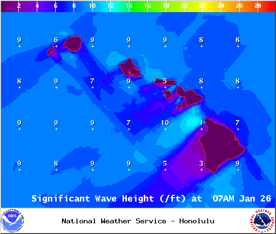
Image: NOAA / NWS

Image: NOAA / NWS

Image: NOAA / NWS

Image: NOAA / NWS
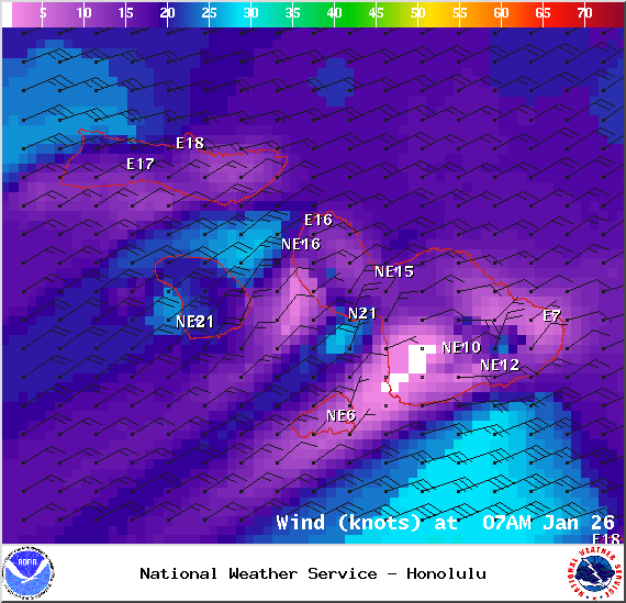
Image: NOAA / NWS

Image: NOAA / NWS
Sponsored Content


