

UPDATE: Guillermo Forecast to Pass 90 Miles NE of Maui on Thursday
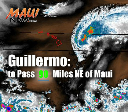
Guillermo. Maui Now graphic. Background image courtesy NOAA/NWS/CPHC
By Wendy Osher
(Update: 5 a.m. 8/5/15)
At 5 a.m., Guillermo was located 250 miles ENE of Hilo and 335 miles E of Kahului, Maui. The system was moving toward the WNW near 9 mph, and is expected to continue on this path over the next couple of days, with a slight increase in forward speed, according to the Central Pacific Hurricane Center.
On the current forecast track, CPHC forecasters say the center of Guillermo is expected to pass about 160 miles NNE of the Big Island of Hawaiʻi late Wednesday night, and 90 miles NNE of Maui on Thursday.
Maximum sustained winds are near 60 mph with higher gusts. The agency states that steady weakening is forecast over the next couple of days. Tropical storm force winds extend outward up to 185 miles from the center, mainly to the north of the center, the agency reports. The chance for tropical storm force winds is 3% in Hilo, and 9% in Kahului, which has trended down, according to the CPHC.
The CPHC says tropical storm conditions are possible on the Big Island of Hawaiʻi and the islands within Maui County later today into Thursday. The current forecast calls for potential total rainfall amounts of 1-3 inches, with maximum amounts near 7 inches mainly in high terrain areas.
On the water, forecasters say swells associated with Guillermo will produce large surf along east facing shores of the main Hawaiian Islands over the next couple of days.
(Update: 2 a.m. 8/5/15)
At 2 a.m., Guillermo was located 290 miles E of Hilo and 375 miles E of Kahului, Maui. The system was moving toward the WNW near 8 mph, and is expected to continue on this path over the next couple of days, with a slight increase in forward speed, according to the Central Pacific Hurricane Center.
On the current forecast track, CPHC forecasters say the center of Guillermo is expected to pass about 175 miles NE of the Big Island of Hawaiʻi late Wednesday night, and 115 miles NE of Maui on Thursday.
Maximum sustained winds are near 60 mph with higher gusts. The agency states that steady weakening is forecast over the next couple of days. Tropical storm force winds extend outward up to 185 miles from the center, mainly to the north of the center, according to agency reports. The chance for tropical storm force winds is 6% in Hilo and 12% in Kahului, which has trended down slightly according to the CPHC.
The CPHC says tropical storm conditions are possible on the Big Island of Hawaiʻi and the islands within Maui County later today into Thursday. The current forecast calls for potential total rainfall amounts of 1-3 inches, with maximum amounts near 7 inches mainly in high terrain areas.
On the water, forecasters say swells associated with Guillermo will produce large surf along east facing shores of the main Hawaiian Islands over the next couple of days.
The Central Pacific Hurricane Center offers the following Preparedness Tips:
- It is vital that you do not focus on the exact forecast track. Forecast movement, direction, and speed are only estimates. Even small errors in the forecast track can mean major differences in where the worst conditions will occur. Damaging effects can extend far from the center.
- For those under a watch, now is the time to prepare. Secure or bring indoors any loose outdoor objects like lawn furniture, childrens toys, hanging plants, barbecue grills, or any item that could become a destructive projectile in strong winds. Do not wait until it is too late.
- Stay calm and keep informed. Closely monitor NOAA weather radio or other local news outlets for official storm information. Listen for warnings or changes to the forecast.
- Be ready to evacuate if necessary. Heed the advice of local officials and comply with any orders that are issued. Persons living near the shore should be prepared to evacuate quickly should building surf threaten.
- Loose objects such as lawn furniture, garbage cans, and other items should be secured or stored indoors. Have supplies on hand and be ready for power outages. Evacuate if ordered by local officials.
(Update: 5:25 p.m. 8/4/15)
The Central Pacific Hurricane Center issued an updated forecast saying tropical storm Guillermo had made a slight shift to the south and is now expected to pass 150 miles NE of the Big Island of Hawaiʻi on Wednesday night, and approximately 120 miles NNW of Maui on Wednesday night.
The agency says the chance for tropical storm force winds is now 10% Hilo and 16% in Kahului. Although the latest forecast is for sustained winds to remain below tropical storm force of 39 mph, forecasters with the CPHC say, “only a small change in the track of Guillermo could result in higher winds.”
In an updated local statement the CPHC states that, “While this forecast track keeps the worst weather away from the islands, any deviation to the left of the expected track could bring tropical storm conditions to portions of the Big Island or Maui. Thus a tropical storm watch remains in effect for those areas.”
(Updated: 3:03 p.m. 8/4/15)
The latest track for tropical storm Guillermo pushes the system even further to the north. As of 2 p.m. on Tuesday, Aug. 4, 2015, Guillermo continued on a northwest path at 8 mph with maximum sustained winds near 70 mph, and was last located about 370 miles east of Hilo (465 miles East of Kahului, Maui).
The latest forecast from the Central Pacific Hurricane Center indicates that Guillermo will pass approximately 230 miles northeast of Hilo on Wednesday afternoon, and approximately 200 miles northeast of Maui on Wednesday night.
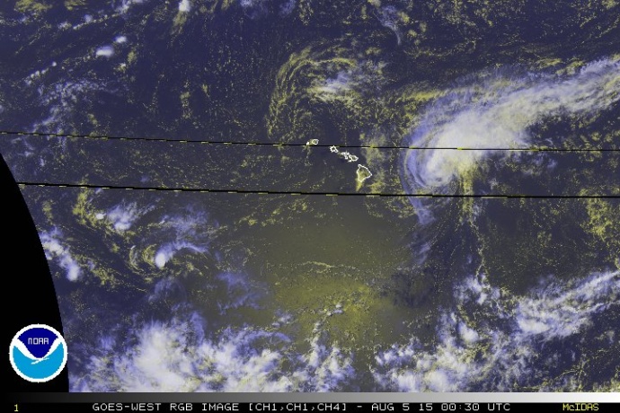
IMAGE: NWS at 2 p on Aug. 4,2 015.
“While this forecast track keeps the worst of the weather away from the islands,” forecasters with the Central Pacific Hurricane Center say “any deviation to the left of the expected track could bring tropical storm conditions to parts of Maui and the Big Island of Hawaiʻi.”
Doug Mayne, Administrator of the Hawaiʻi Emergency Management Agency said, “We have been advised by the National Weather Service that although Guillermo is slowly weakening, we may still be vulnerable to the storm’s impacts. Residents and visitors alike should continue preparing to ensure the safety of their dwellings and families in the event of heavy rainfall, which has the potential to affect all islands through Thursday.”
Current models forecast Guillermo continuing on a northwest track above the state and weakening as wind shear increases along its path, agency officials said.
A Tropical Storm Watch remains in effect for Hawaiʻi County and all islands in Maui County, which means that tropical storm conditions are possible within the watch area. Hawaiʻi and Maui Counties are also under a Flash Flood Watch.
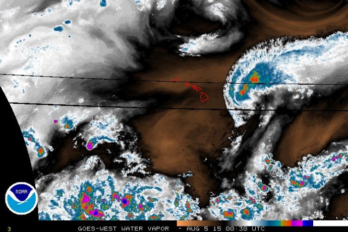
Water Vapor IMAGE: NWS at 2 p on Aug. 4,2 015.
The Hawaiʻi Emergency Management Agency issued the following recommendations:
- Be aware of streams, drainage channels, roads, and other areas known to flood suddenly.
- Use 9-1-1 only to report life-threatening emergencies.
- Make sure to monitor local broadcasters and/or sign up for local notification systems if you live in a flood prone area.
- Gather important documents such as your flood insurance policy. Flood losses are not covered under normal homeowners’ insurance policies.
- Be aware that flash flooding can occur quickly and without warning. Be prepared to evacuate and move immediately to higher ground. Do not wait for instructions to move.
- Secure your home and elevate essential items. Turn off utilities if instructed to do so. Disconnect electrical appliances and do not touch electrical equipment if you are wet or standing in water.
- Do not attempt to cross fast moving water, especially if you are unsure of the depth.
Hurricane season in Hawaiʻi runs from June 1 through November 30. During this time, the islands are most susceptible to a hurricane threat.
This year, the National Oceanic and Atmospheric Administration is forecasting an “above-normal” hurricane season with 5 to 8 tropical cyclones expected to affect the Central Pacific this season. That’s more than the average season of 4 to 5 tropical cyclones in a typical year. This includes tropical depressions, tropical storms and hurricanes.
The Central Pacific Hurricane Center offers the following tips and information:
- A tropical storm or hurricane watch is issued when conditions are expected in the specified area of the watch, usually within 48 hours.
- Listen to NOAA Weather Radio and local media outlets for the latest weather information.
- Store at least 7 days worth of drinking water and non-perishable food.
- Fill your car’s gas tank, and know the best route to evacuate.
- A tropical storm or hurricane warning is issued when conditions are expected in the specified area of the warning, usually within 36 hours. Be prepared to shelter in place or to evacuate immediately, if emergency management officials advise it.
Some helpful links for the public to familiarize themselves with include the following:
- Hawaiʻi Boater’s Hurricane and Tsunami Safety Manual
- For more information on hurricane preparedness, visit the National Hurricane Center online.
- Visitors can download and read the Hawaiʻi Tourism Authority’s Travel Safety Brochure.
- Continue to tune in to local broadcasts for information and instructions on Guillermo. Updates are being posted in the upper portion of our website by Maui Now Meteorologist Malika Dudley. Pacific Media Group’s six Maui radio stations will also be providing updates as warranted at the following frequencies: KPOA 92.5 FM; NATIVE 92.5 FM; KISS FM Maui 99.9 FM; Da Jam 98.3 FM, ESPN 900 AM; and KNUI 550 AM.
- Follow the Department of Education online for the latest information on possible school closures. Make sure you know the closure notification procedure if your children attend a private or charter school.
***For today’s latest update from Maui Now Meteorologist Malika Dudley, click HERE.
Sponsored Content


