

Atsani and Kilo Expected to Generate Swells

Image: Chris Archer
By Meteorologist Malika Dudley / Email: malika@mauinow.com
Alerts
A Flood Watch remains in effect until 6 p.m. Monday for all islands. An unstable and very moist air mass on the back side of the tropical system is lingering across the state. This moisture interacting with the land is expected to produce periods of heavy rain and slow-moving downpours that could lead to flash flooding. If that occurs a more urgent Flood Advisory (flooding is imminent) or Flood Warning (flooding is occurring) will be posted by the National Weather Service.
A Marine Weather Alert is posted for mariners. The NWS says to be prepared to encounter visibility near zero in very heavy showers and to be alert for dangerous cloud to surface lightning strikes. If caught on the open water during a thunderstorm, stay below deck. Thunderstorms also have the ability to produce sudden waterspouts which can easily overturn small boats and create locally hazardous seas.
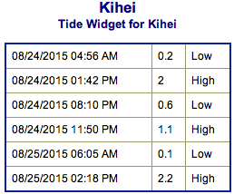
**Click directly on the images below to make them larger. Charts include: Maui County projected winds, tides, swell direction & period and expected wave heights.**
 Maui Surf Forecast
North: Wave heights of about waist/chest high are expected today for the best breaks. Spots not catching the northeast swell will be pretty flat.
West: Wave heights ankle/knee high are expected at the breaks catching the south. Spots catching the west swell hold around waist high later in the day. Spots shadowed by other islands will be smaller or even flat.
South: Wave heights knee/waist high are expected at the breaks catching the south. Spots catching the west hold around waist high.
 Our current south-southeast swell is fading while a small southwest swell mixes in. Thursday into the weekend we expect some fun surf to build into the waist/chest high range.
Super Typhoon Atsani is sending west swell which is expected to peak Monday and hold into Tuesday / Wednesday. Models are showing Atsani turning extratropical next week. If this happens, we can expect more swell from Atsani through the work week.
Kilo may also bring us swell if it stays on the current forecast. If so, we expect short-period southwest swell around Wednesday / Thursday.
Keep in mind, surf heights are measured on the face of the wave from trough to crest. Heights vary from beach to beach, and at the same beach, from break to break.
**Click here for your detailed Maui County weather report.**

Image: NOAA / NWS

Image: NOAA / NWS
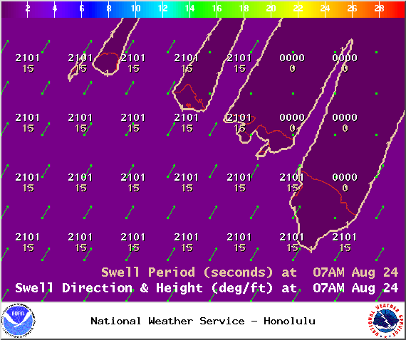
Image: NOAA / NWS
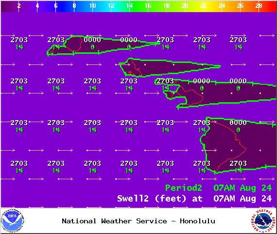
Image: NOAA / NWS

Image: NOAA / NWS

Image: NOAA / NWS
Sponsored Content


