

Spring Tides Continue, Trade Swell Bump Expected

Image: Asa Ellison
Alerts (as of 1:00 a.m.)
Special Weather Statement: Coastal flooding associated with spring tides (King tides) is occurring and expected through mid-week. The greatest potential for flooding is during the peak daily tide.
Small Craft Advisory: Through 6 p.m. Thursday with winds up to 25 knots.
**Click directly on the images below to make them larger. Charts include: Maui County projected winds, tides, swell direction & period and expected wave heights.**
Maui Surf Forecast
North: Surf heights are expected to be knee/waist high in the morning and up to shoulder/head high by sunset.
West: Surf heights are expected to be knee/waist high or less today. Many spots will be flat.
South: Surf heights are expected to be knee/waist high or less today.
A small southwest is forecast to fill in for the weekend. That same storm system which generated this small swell is forecast to push some small south-southwest toward us around the 28th as well. A stronger storm could bring a better swell starting on the 31st. Will keep an eye on it.
Trade swell is forecast to bump up a bit today and into the middle of the week. Tropical system, Kenneth, is forecast to generate some swell for the islands starting late Wednesday and peaking Thursday/Friday up to about chest high.
Keep in mind, surf heights are measured on the face of the wave from trough to crest. Heights vary from beach to beach, and at the same beach, from break to break.
**Click here for your detailed Maui County weather report.**

Image: NOAA

Image: NOAA

Image: NOAA

Image: NOAA

Image: NOAA
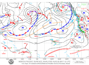
Image: NOAA
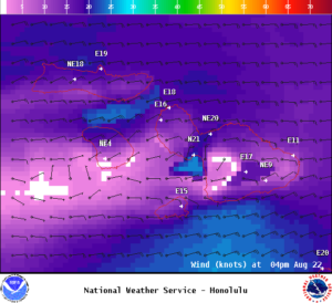
Image: NOAA
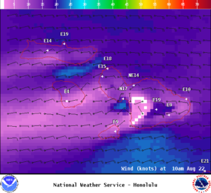
Image: NOAA
Sponsored Content


