


Category 2 Douglas Continues Move Toward Hawaii (7:40 a.m. Update)
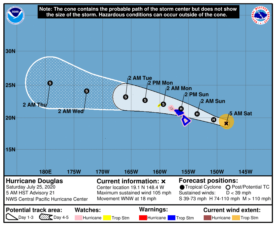
Douglas. (5 a.m. 7.25.20) PC: NOAA/NWS/CPHC
• Category 2 Douglas Continues Move Toward Hawaii (5 a.m. Update)
• 2020 Hurricane Season in Hawaiʻi
• Storm Prep and Kits
• Ige Issues Emergency Proclamation Ahead of Douglas
• Maui Mayor Issues Emergency Proclamation for Hurricane Douglas
• Mayor Victorino urges Maui to Prep for Potential Impacts
Update: 7:41 a.m. (Posted: 5 a.m. 7.25.20)
Hurricane Douglas underwent slight weakening overnight, but remains a Category 2 Hurricane with maximum sustained winds of 105 mph. The system was last located about 400 miles E of Hilo and 635 miles ESE of Honolulu. Present movement is toward the WNW at 16 mph.
Watches and Warnings:
Since the last update, Kauaʻi County has been added to the Tropical Storm Watch list–this includes both the islands of Kauaʻi and Niʻihau.
Maui and Hawaiʻi Counties are under a: Tropical Storm Warning and Hurricane Watch.
Oʻahu is under a Hurricane Watch.
What it Means: A Tropical Storm Warning means that tropical storm conditions are expected somewhere within the warning area within 36 hours. A Hurricane Watch means that hurricane conditions are possible within the watch area, in this case within the next 36 to 48 hours. A Tropical Storm Watch means that tropical storm conditions are possible within the watch area, in this case within the next 36 to 48 hours.
Overview of Movement and Strength:
The Central Pacific Hurricane Center reports that the present motion of Douglas is expected with a slight decrease in forward speed today, followed by a slight turn toward the west tonight through Monday. The latest forecast brings Douglas near the main Hawaiian Islands late tonight through Sunday night.
While gradual weakening is expected through the weekend, Douglas is still forecast to be near hurricane strength when it nears the islands.
The CPHC reports that hurricane-force winds extend outward up to 25 miles from the center and tropical-storm-force winds extend outward up to 105 miles.
Potential Hazards as outlined by the CPHC:
WIND: Hurricane conditions are possible across portions of the main Hawaiian Islands late tonight through Sunday night. Tropical Storm conditions are expected across Hawaiʻi County and Maui County beginning late tonight or Sunday. Tropical Storm conditions are possible across Kauaʻi County late Sunday or Sunday night.
SURF: Large swells generated by Douglas are expected to affect the Hawaiian Islands this weekend. These swells are likely to cause life-threatening surf and rip current conditions for the next couple of days.
RAINFALL: Heavy rainfall associated with Douglas is expected to affect portions of the main Hawaiian Islands from late tonight through Monday. Total rain accumulations of 5 to 10 inches are possible from Maui County westward to Kauaʻi County, with the greatest amounts in elevated terrain. This rain may result in life-threatening flash flooding and land slides, as well as rapid water level rises on small streams. Douglas is expected to produce 2 to 5 inches of rainfall over the northern half of the Big Island.
*The next intermediate advisory will be issued at 8 a.m.; and the next complete advisory will be issued at 11 a.m. Information based on Central Pacific Hurricane Center forecast.

Douglas. (5 a.m. 7.25.20) PC: NOAA/NWS/CPHC
Sponsored Content


