

Flood Advisory for Maui until 2 p.m.; Flood Watch for Hawaiʻi Island through this afternoon
Flood Warning for Hawaiʻi Island canceled as of 12:05 p.m.
The National Weather Service has canceled the Flood Warning for the Big Island as of 12:05 p.m. The heavy rain has ended. Flooding is no longer expected to pose a threat. A Flood Watch remains in effect until 6 p.m. for the Big Island.
Flood Advisory extended for Maui until 2 p.m.:
The National Weather Service has extended a Flood Advisory for the island of Maui until 2 p.m. due to excessive rainfall. At 10:48 a.m., radar showed heavy rain over Maui. Rain was falling at a rate of 1 to 2 inches per hour. Some locations that will experience flooding include: Kahului, Kīhei, Lahaina, Kula, Pukalani, Makawao, Kēōkea, Hāliʻimaile, Pāʻia, Puʻunēnē, Haʻikū-Paʻuwela, Wailea, Paʻuwela, Māʻalaea, Huelo, ʻUlupalakua, Mākena, Waikapū, Wailuku and Waiehu.
At 7:58 a.m., radar showed heavy rain over windward locations of Maui, falling at a rate of 1 to 2 inches per hour.
Flood Watch for Big Island through this afternoon
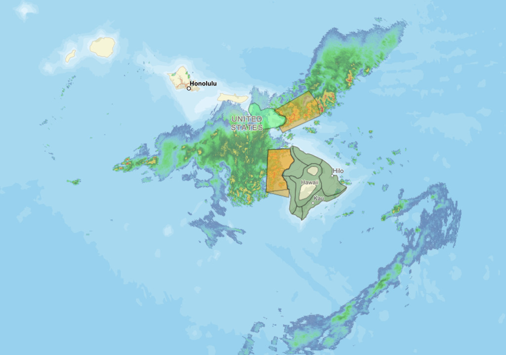
The Big Island remains under a Flood Watch through this afternoon as unstable tropical moisture left from the departing kona low continues to bring the threat of isolated thunderstorms and rainthrough this afternoon. A band of thunderstorms continues to approach the Big Island from the west-southwest direction, which may produce another round of heavy rainfall later today.
Previous posts:
Flood Warning until 1 p.m. for Hawaiʻi Island
The National Weather Service has issued a Flash Flood Warning for the island of Hawaiʻi until 1 p.m. At 10:22 a.m., radar showed heavy rain over Kona and Kohala areas. Rain was falling at a rate of 2 to 3 inches per hour. Flash flooding is ongoing or expected to begin shortly. Flooding in drainages, streams, rivers, roads, properties, and other low-lying areas. Public road closures possible in some areas. Landslides are possible in steep terrain. Some locations that will experience flash flooding include: Kailua-Kona, Captain Cook, Waikōloa Village, Kapaʻau, Puʻuanahulu, Puakō, Kalaoa, Holualoa, Kawaihae, Honalo, Kamuela, Kahaluu-Keauhou, Kohala Ranch, Kainaliu, Kealakekua, Honaunau, Waimanu Valley, Waipiʻo Valley, Pololū Valley and Kukuihaele.
Flood Advisory until 1 p.m. for Hawaiʻi Island
The National Weather Service has issued a Flood Advisory until 1 p.m. for Hawaiʻi Island. At 9:57 a.m., radar showed heavy rain over Kona and Kohala areas. Rain was falling at a rate of 1 to 2 inches per hour. Some locations that will experience flooding include: Kailua-Kona, Captain Cook, Waikōloa Village, Kapaʻau, Puʻuanahulu, Puakō, Kalaoa, Holualoa, Kawaihae, Honalo, Kamuela, Kahaluʻu-Keauhou, Kohala Ranch, Kainaliu, Kealakekua, Honaunau, Waimanu Valley, Waipiʻo Valley, Pololū Valley and Kukuihaele.
Strong Thunderstorms to impact Hawaiʻi Island through 10:30 a.m.
The National Weather Service says strong thunderstorms will impact the Big Island through 10:30 a.m. At 9:35 a.m., Doppler radar was tracking a cluster of strong thunderstorms along a line extending from near Hawi to 5 miles southwest of Kahaluʻu-Keauhou. Movement was east at 15 mph, and wind gusts are blowing at up to 50 mph. Locations impacted include: Captain Cook, Puʻuanahulu, Hawī, Mahukona, Honaunau, Kawaihae, Kahaluʻu-Keauhou, Waikoloa Village, Kainaliu, Kealakekua, Honalo, Pololū Valley, Kohala Ranch, Kalaoa, Halaula, Kapaʻau, Waimanu Valley, Puakō, Kailua-Kona, and Holualoa.
Sponsored Content


