 Hawai'i Journalism Initiative
The rain is coming again: Why a third major storm in a month is heading for Hawai‘i
An “unusual” third major storm in less than a month is heading for the Hawaiian islands this week, bringing winds and more precipitation to Maui County, which already has dealt with multiple floods and record-setting rain.
This strange bout of weather could be tied to the record-setting heat wave across the U.S. West Coast, where more than 150 daily temperature records were broken in a span of five days in March due to a ridge of high pressure over the area, said Joseph Clark, meteorologist with the National Weather Service’s Honolulu office.
The weather patterns are like an ocean wave going up and down, Clark said. The ridge over the West Coast is like the crest of the wave, and Hawai‘i is in the trough where a jetstream is coming down and directing a lot of energy toward the islands, which is ultimately creating the rain.
HJI Weekly Newsletter
Get more stories like these delivered straight to your inbox. Sign up for the Hawai‘i Journalism Initiative's weekly newsletter:
“There’s a direct link between … the kind of record rain here and the record heat on the West Coast,” Clark told the Hawai‘i Journalism Initiative Tuesday. “We’re on two sides of the same coin.”
The impacts of that ridge may recede heading into mid-April, and with trade winds starting to set in over the next few weeks, fairer weather could be ahead, Clark said.
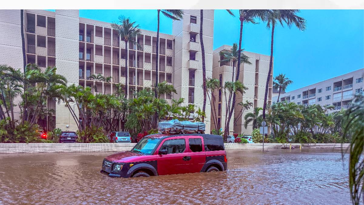
But before it arrives, Maui County will again have to deal with a storm, which is forecast to pass over Hawaiʻi in the coming days. All islands are under a flood watch from 6 a.m. Wednesday through 6 p.m. Friday, with “significant flooding” and “overflow of streams and drainages” possible, the National Weather Service warned. The heaviest rainfall is expected in Maui County Thursday night through Friday.
This storm will leave a “tropical moisture band” over the islands that could result in cloudy, humid conditions even after it passes.
“The atmosphere is going to be ready to produce showers if we get any energy that comes down,” Clark said. “So we might have a few periods of showers, maybe even a little bit of heavy rain, late this weekend and early next week. But that should be fairly sporadic in nature.”
He also said the storm should move along quickly: “It’s not just going to stagnate in one place, but I think it could be fairly intense, so it could cause problems in a short period of time.”

Maui County could see several inches of rain — forecasts through Thursday predict 3 to 10 inches for East Maui, 3 to 6 inches for Moloka‘i and 2 to 4 inches for Lāna‘i. But Maui island could be spared from strong winds because they will stay southeast, putting Maui in Hawai‘i island’s shadow, which could reduce wind speeds, Clark explained. Heavy rains on Thursday and Friday could still bring some isolated strong gusts.
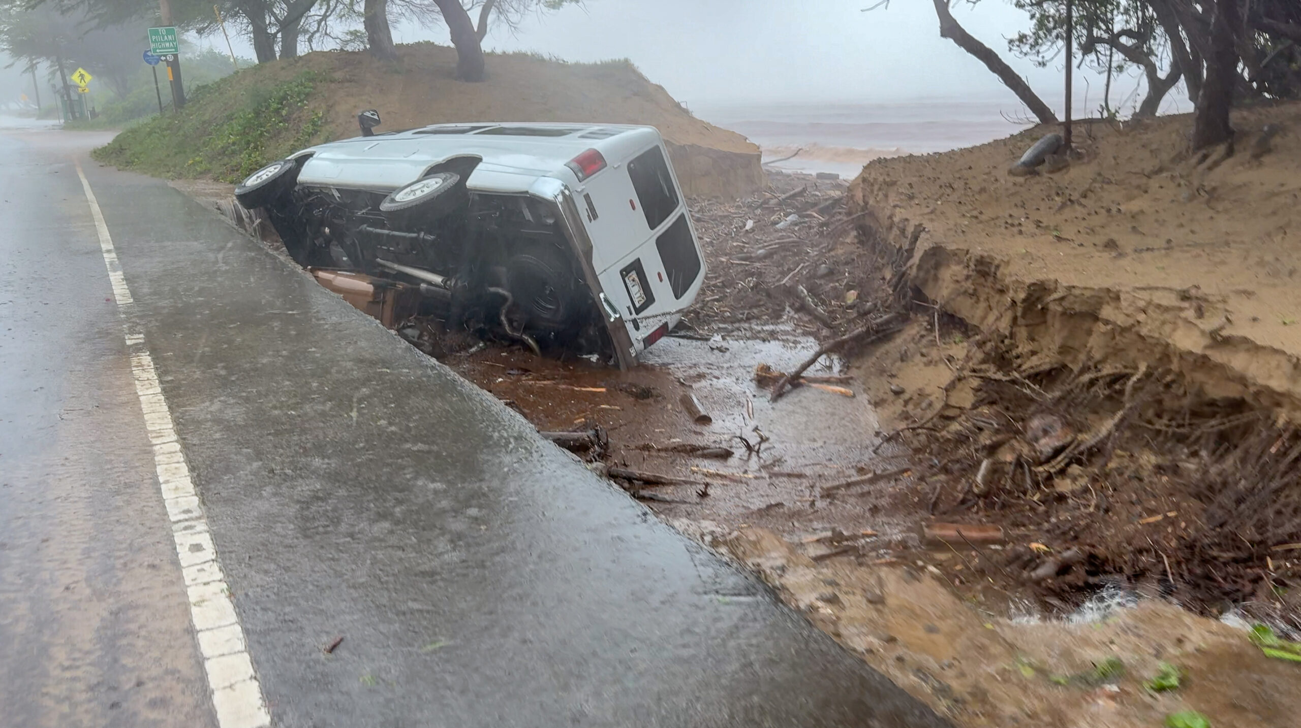
The storm comes as communities are still recovering from two Kona low systems on back-to-back weekends in March that generated massive rain and flooding, undermined roads, damaged critical infrastructure and washed away homes.
During the first storm, the summit of Haleakalā and areas of Kula saw nearly 50 inches of rain, according to National Weather Service data.
Clark said it’s hard to say how the latest storm will compare to the last two in March, “because the storm is different for every particular location.” And while a couple of weeks of sunnier weather has helped dry out the oversaturated ground, it still hasn’t recovered completely.
He said it’s “pretty unusual” to have this much rain and so many storms in such a short period of time. March was the wettest month ever for Kahului since the National Weather Service started keeping statistics in 1954, logging 21.11 inches of rain, the agency’s historical records show. With a total of 25.34 inches of rain in Kahului from January to March, it’s the wettest start to the year ever for the area.
“It’s still raining and there’s more coming,” Clark said.
Other areas are also seeing a significantly wetter start through the first three months of the year, including:
- Hāna with 57.07 inches of rain, up from 28.34 during the same period last year.
- Wailuku with 46.08 inches, up from 10.76.
- Lāna‘i City with 37.78 inches, up from 10.76.
- Pukalani with 37.25 inches, up from 6.52.
- Lahainaluna with 29.57 inches, up from 6.07.
- Kaunakakai with 24.79 inches, up from 4.68.
The Kula station that logged nearly 50 inches of rain during the first Kona low wasn’t included in the National Weather Service’s historical data.
Clark said the alternating climate patterns of El Niño and La Niña could also be behind the recent strange weather, though “that’s always a little hard to tease out.” The Pacific is currently under La Niña conditions and heading toward an El Niño this summer.
Fellow meteorologist Stephen Parker told the Hawai‘i Journalism Initiative last month that people often have a misconception of the role La Niña and El Niño play. They’re part of the overall atmospheric system and can influence conditions, but they are “not controllers of the weather.” Rather, it’s a combination of all the atmospheric factors — pressure, winds, cold air — that can create unstable conditions leading to deeper and stronger storms.

State and county officials are calling on the public to prepare for the upcoming storm.
Maui Emergency Management Agency Administrator Amos Lonokailua-Hewett urged both residents and visitors to stay informed, create an emergency plan and emergency kit, and secure their property, especially those in low-lying or flood-prone areas.
“With soils already saturated, even lighter rainfall can quickly create dangerous conditions,” he said in a county news release on Tuesday. “We encourage everyone to remain vigilant and stay connected with those around you — especially kūpuna, keiki and neighbors who may need extra support.”
Hawai‘i Gov. Josh Green and the Hawai‘i Emergency Management Agency also cautioned the public to be alert to possible flash flooding, especially around waterways, ravines, valleys, gulches and paved areas like streets and parking lots.
County crews are hustling to shore up vulnerable areas. South Kīhei Road, which was undermined in multiple areas during the first Kona low storm, will be closed between North Kīhei Road and Ohukai Road starting today through April 15 for repairs. Only local access will be allowed.
The county said that the Department of Public Works has been removing debris from roadways and storm drains and putting in emergency protective measures to stabilize damaged infrastructure. The county also has completed assessments of all flood control systems to make sure they are in good condition.
The Department of Water Supply and Department of Environmental Management are also preparing all sites that could be impacted by the storm. Generators and vehicles are being refueled, and standby crews have been set up for response.
The Maui Police Department has increased staffing in all districts and tested generators at all its stations.
“Our community has already endured so much in the wake of two recent Kona storms, and we recognize the strain and uncertainty many are still carrying,” Maui County Mayor Richard Bissen said in a news release Tuesday. “With a third kona storm now on the horizon, know that our County teams remain fully engaged, continuing response and recovery efforts without pause.”
Both the county and the state are calling it a Kona low storm. Clark said it’s not quite a Kona low, which usually comes farther south, but ultimately it doesn’t matter what people call it because the impacts will be the same.
The recent rain has helped eliminate drought statewide, with parts of Maui island now under “abnormally dry” conditions, the lowest level of drought. But the rain has resulted in lots of lush, green vegetation growing throughout the landscape, which could create a fire risk in the summer.
Clark pointed out that there’s concern either way — a dry winter means elevated fire risk in the summer, but a wet winter creates worries of more vegetation to dry out and burn. With an El Niño pattern expected in late summer to fall, conditions could be a little wetter than normal and the landscape could dry out less, “but I wouldn’t necessarily count on it.”
“It doesn’t matter if winter is wetter or drier,” Clark said. “Either way, you’re drying out eventually during the summer most years.”
Weather conditions are available at www.weather.gov/hfo/. Members of the public can also subscribe to Genasys and MEMA alerts at mauicounty.gov/MEMA for local updates or ready.hawaii.gov/alerts for statewide updates.