Hurricane Fausto predicted to weaken, elevated risk of wind and rain impacts for Hawaiian Island chain
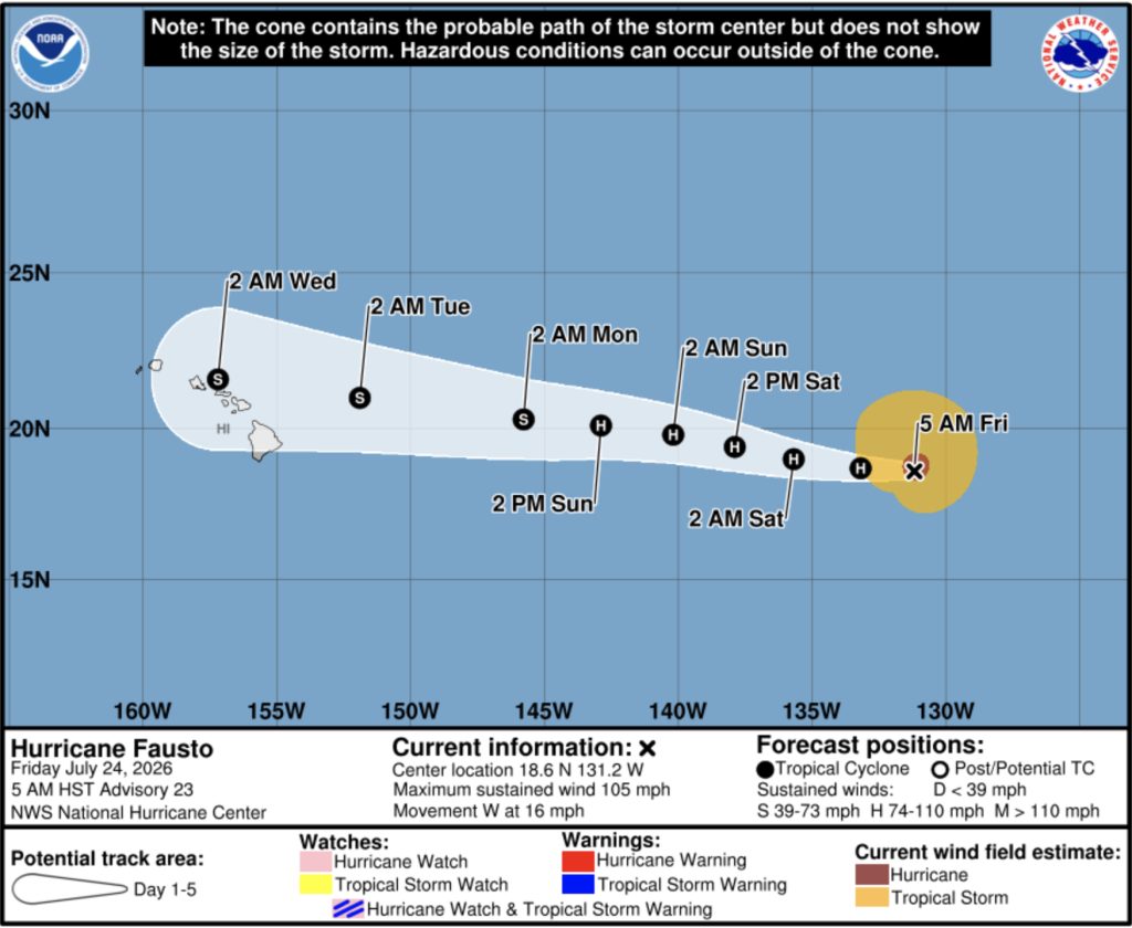
Hurricane Fausto is expected to weaken before it nears the Hawaiian Islands early to mid next week, but forecasters say the risk of wind and rainfall impacts on the islands is increasing, according to the National Hurricane Center in Miami.
For information about hurricane safety and preparedness, visit the Maui Emergency Management Agency website by clicking here.
Fausto is “likely near its peak intensity,” the center said in its 5 a.m. discussion Friday, with steady weakening expected through the period. Forecasters said there is relatively high confidence Fausto will have weakened to a tropical storm by the time it is in the vicinity of Hawaiʻi. Still, they cautioned it is too early to pinpoint the exact location or magnitude of any wind and rain impacts, and they are urging continued monitoring as the storm approaches the island chain.
As of 5 a.m. Friday, Fausto had strengthened into a well-organized hurricane with maximum sustained winds of about 105 mph, up from 75 mph when it reached Category 1 strength Monday. Satellite estimates put the storm’s intensity in a range of roughly 89 to 117 mph, and forecasters said the hurricane has developed a fairly symmetric cloud pattern with a closed ring of deep convection surrounding an eye about 17 miles in diameter.
Fausto was moving westward at about 16 mph Friday morning. The Hurricane Center said the track forecast is “fairly straightforward,” with a narrow ridge of high pressure expected to hold in place north of the storm over the next several days, steering it westward to west-northwestward at a similar pace. That track would bring Fausto near the Hawaiian Islands during the early to middle portions of next week.
Forecasters said the weakening trend expected to begin early next week is likely to be driven by cooler ocean water, drier air and an increase in westerly wind shear. They noted, however, that recent model guidance has struggled to accurately capture Fausto’s intensity changes over the past several days, adding some uncertainty to the forecast.
The system’s wind field is smaller than average compared with other hurricanes that have tracked through similar parts of the Pacific, according to the discussion.
Maui Now reported Monday, when Fausto was a tropical storm in the eastern North Pacific, before it strengthened into a hurricane later that day.
Maui County residents are encouraged to monitor updates from the National Hurricane Center and stay tuned to local forecasts as Fausto’s track becomes clearer in the coming days.
Sponsored Content