Henriette Strengthens to Hurricane, Gil is Tropical Depression
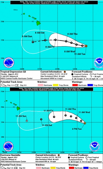
Tropical Depression Gil and Hurricane Henriette, 11 a.m. 8/6/13. Image courtesy NWS/NOAA/CPHC.
By Wendy Osher
(Update: 10:54 a.m. 8/6/13)
Tropical Depression Gil is now located about 975 miles ESE of Hilo, and has dropped from a storm back down to a depression with sustained winds near 35 mph, according to the NWS & CPCH.
Hurricane Henriette is now about 1545 miles E of Hilo, Hawaiʻi, with maximum sustained winds increasing to 90 mph.
(Update: 7:06 a.m. 8/6/13)
Forecasters continue to track two systems in the Pacific that both strengthened overnight.
As of 5 a.m. on Tuesday, Aug. 6, Gil had shifted back to ‘tropical storm’ status.
According to the latest estimates released by the National Weather Service’s Central Pacific Hurricane Center, TS Gil was located 975 miles E/SE of Hilo, and 1095 miles E/SE of Kahului.
The system had sustained winds of 40 mph and was continuing on a path west at 9 mph, according to the CPHC.
At 5 a.m., Henriette, now a hurricane, was located 1600 miles E/SE of Hilo, and about 1700 miles E/SE of Kahului, according to NWS forecasts.
The system had sustained winds of 80 mph and was on a path to the northwest at 10 mph.
According to a forecast discussion released by the National Hurricane Center, Henriette should remain over warmer water during the next 24 hours, allowing for some additional strengthening. After that time, the forecast states that Henriette will move into a drier and more stable air mass, which should result in gradual weakening over the remaining forecast period.
Authorities continue to track both systems and remind the public that forecasts can and often do change.
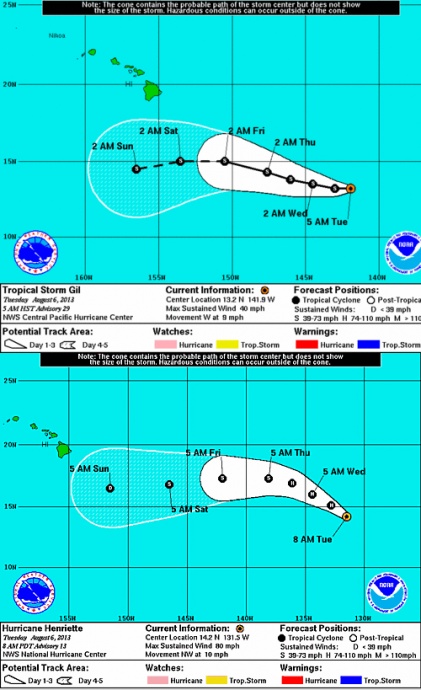
Tropical Storm Gil and Hurricane Henriette, 8/6/13. Image courtesy NWS/NOAA/CPHC.
Sponsored Content