

Malika Dudley’s Maui County Forecast (10/26/14)
By Meteorologist Malika Dudley / Email: malika@mauinow.com
**A breakdown of expected conditions specific to Maui County is presented below in graphical form. High and low temperatures, swell, percent chance of clouds / rain and wind conditions are each depicted. All graphics are provided by the National Weather Service in Honolulu.**
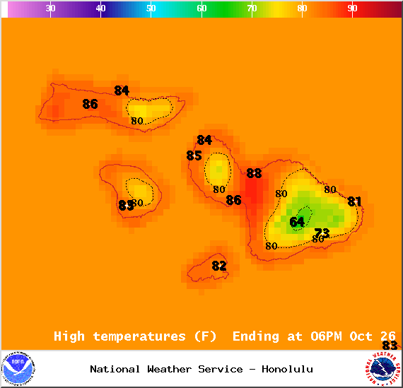
Map of expected high temperatures in Maui County on Sunday October 26, 2014 / Image: NOAA / NWS
Alerts
There are no alerts posted for Maui County at this time.
Today
What’s left of an old front sagging toward the state will bring mostly cloudy skies for windward and mauka areas with frequent showers forecasted through the morning. Scattered showers are expected as we head into the afternoon. Leeward spots can expect scattered morning showers from time to time giving way to more sunshine by the afternoon with only isolated showers forecasted for later in the day. High temperatures should fall in the range of 84° to 89° with higher elevations experiencing lower temperatures overall. Winds should be out of the east from 10 to 15 mph. Breezier through the Central Valley on Maui with winds from 10 – 20 mph expected. Lānaʻi and Molokaʻi will get more of a northeasterly flow at 10 – 15 mph.
Sunrise: 6:26 a.m.
Sunset: 5:54 p.m.
UV index at 8 (“very high” exposure level)

Map of expected overnight low temperatures in Maui County on Sunday October 26, 2014 / Image: NOAA / NWS
Tonight
Tonight we expect mostly cloudy skies with showers likely for windward and mauka areas. Partly cloudy skies leeward with just isolated showers. East winds are expected to hover around 15 mph. Low temperatures should fall in the range of 73° to 78° with lower temperatures recorded at higher elevations.
Looking Ahead
Light to moderate trades early in the week should allow local land and sea breeze conditions to develop. Models are showing enhanced windward and mauka showers Tuesday and Wednesday. A front is also expected to enhance showers Thursday night into Friday (Halloween). I’ll keep an eye on this feature and bring you the latest if anything changes. We don’t want our trick-or-treaters to get rained out! Following the front, we expect stronger winds, cooler air and lower humidity.
 Surf & Seas
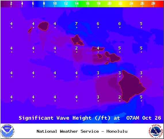
Our current north swell (350-10°) has already peaked and should slowly fade through the day today. Chest to head high waves are expected early on dropping to about waist to chest high by the afternoon / evening. Just knee to waist high waves expected by Monday. Certain west side breaks that don’t catch a north will only get ankle-slappers today. A series of small north swells is expected through Wednesday, with a slightly larger north swell expected to start building late Wednesday. Larger short period easterly swells area expected late in the week as trade winds strengthen.
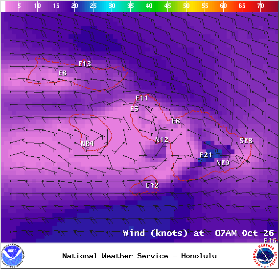
Wind conditions in Maui County at 7am on Sunday October 26, 2014 / Image: NOAA / NWS
Our small south-southwest (200-190°) swell has dropped down to trace amounts. Another small boost is expected by mid-week offering knee to waist high surf, possibly bigger at the best exposures. For the second half of the week surf goes quiet with not much on the horizon either.
If ANA continues on its current forecast track the remnants of ANA are expected to merge with a storm to our north. If that happens we may see some swell generated from “ANA” late Wednesday into Thursday. Otherwise, ANA is not looking to be a big swell producer, maybe pushing heights up to about waist high.
Keep in mind, surf heights are measured on the face of the wave from trough to crest. Heights vary from beach to beach, and at the same beach, from break to break.
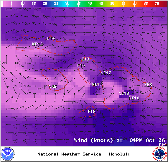
Wind conditions in Maui County at 4pm on Sunday October 26, 2014 / Image: NOAA / NWS
Almanac for Kahului Airport
Maximum Temperature for today:
Normal 86°
Record 91° / Set in 1980 and tied in 2003 & 2004
Minimum Temperature for today:
Normal 69°
Record 59° / Set in 1949

Haleakalā / Image: Krannichfeld Photography
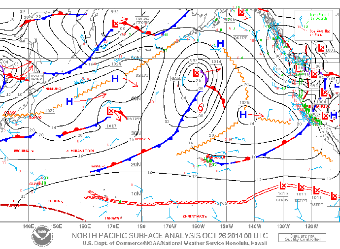
Weather features in the North Pacific / Image: NOAA / NWS
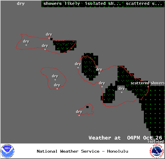
Weather conditions in Maui County at 4pm on Sunday October 26, 2014 / Image: NOAA / NWS
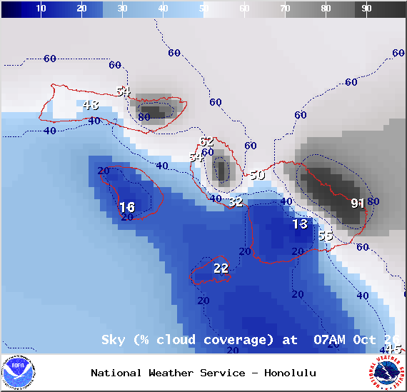
Chance of cloud cover in Maui County at 7am on Sunday October 26, 2014 / Image: NOAA / NWS

Chance of cloud cover in Maui County at 4pm on Sunday October 26, 2014 / Image: NOAA / NWS

Weather conditions in Maui County at 7am on Sunday October 26, 2014 / Image: NOAA / NWS
Sponsored Content


