

Hilda Expected to Make Landfall as Tropical Depression

Hilda 11 p.m. CPHC track forecast August 9, 2015
By Meteorologist Malika Dudley / Email: malika@mauinow.com
(Updated at 11:00 p.m. August 9, 2015)
Not much has changed since the 5 p.m. update. Hilda still has maximum sustained winds at 100 mph and the forecast track has not changed much. The system is expected to make landfall on the Big Island sometime Friday as a tropical depression.
Hilda is currently located 795 miles ESE of Hana, 600 miles SE of Kahului, 645 miles SE of Kaunakakai and 625 miles SE of Lanai City. The storm is expected to become a tropical storm by Tuesday.
All other forecast guidance (see below) remains unchanged.
(Updated at 5:00 p.m. August 9, 2015)
Hilda has continued its gradual weakening trend today but is still a category 2 hurricane. On satellite the system looks more ragged and the eye is not as visible as it once was.
As of the 5:00 p.m. Central Pacific Hurricane Center update, the system has maximum sustained winds at 100 mph with higher gusts. This gradual weakening trend is expected to continue over the next couple of days due to vertical wind shear and cooler sea surface temperatures.
5:00 pm NWS Satellite Hilda August 9, 2015
The storm, located 665 miles SE of Kahului, 715 miles SE of Kaunakakai and 685 miles SE of Lanai City, is moving NW at 10 mph. Hilda is expected to continue tracking NW for the next 36 hours before veering back toward the WNW through 48 hours.
What’s interesting about this system is that the strength of the storm needs to be looked at together with the track. The weaker and shallower the system becomes, the more likely it will be to take a more westward track. If Hilda goes against current forecast guidance and models, the system could take a more northerly path.
Hurricane force winds extend 25 miles from the center and tropical storm force winds extend up to 70 miles from the center.
Hurricane Hunters are expected to fly into Hilda this evening. This data will give us a much better idea of exact positioning and will help with future forecasting.

Hilda 11 a.m. track forecast
(Update 11:00 a.m. August 9, 2015)
Hurricane Hilda is now 720 miles SE of Kahului, 770 miles SE of Kaunakakai and 740 miles SE of Lanai City. The system has slowed down a tad and is now traveling WNW at 10 mph. Maximum sustained winds have also weakened slightly, now at 110 mph making it a category 2 hurricane.
The track has again shifted farther to the left of the previous track. The center line of the forecast cone now has Hilda making landfall as a tropical depression Friday morning. The Central Pacific Hurricane Center is issuing track and intensity forecasts simultaneously with regards to Hilda because one affects the other in this case. If Hilda weakens rapidly as expected, the system will be a much shallower storm and the trade winds will likely help steer the system in a more westerly direction toward the islands. If the system were to go against current forecast guidance and remain a stronger and deeper system the track will likely be steered by a deeper layer of the atmosphere and go farther north.
Other than that, not much has changed with the forecast guidance outlined below in the 8:00 a.m. update.
(Update 8:00 a.m. August 9, 2015)
[flashvideo file=http://www.youtube.com/watch?v=z1tLzGiv8yw /]
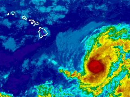
Hilda has weakened a bit but is still a Category 3 hurricane. The system grew in size yesterday as rapid strengthening was occurring and is now looking a bit smaller and more compact. As of the Sunday morning Central Pacific Hurricane Center update, the system looks a bit ragged with a cloud-filled eye and has shrunk in size.
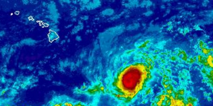
Image: NWS satellite at 8 a.m. August 9, 2015
Hilda has maximum sustained winds at 115 mph with higher gusts. A gradual weakening trend is expected today with faster weakening anticipated Monday and Tuesday.
The storm, located 770 miles SE of Kahului, 820 miles SE of Kaunakakai and 790 miles ESE of Lanai City, continues to move WNW at 13 mph. A gradual turn to the northwest and a decrease in speed are expected over the next 48 hours or so.
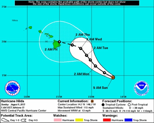
Image: CPHC 5 a.m. track Hilda August 9, 2015
On day 3 the track has again shifted westward. On days 4 and 5 the track has shifted southwestward. This forecast guidance brings the cyclone closer to the Hawaiian Islands than in previous weather model runs. If this track remains true, Hilda will approach the Big Island as a tropical depression early Friday.
Having said that, it’s important to focus on the entire forecast cone and not uniquely on the middle line of the track.
Keep in mind, the lines of the forecast cone show where the center of the system might go and with high winds and moisture extending well away from the center of these systems, weather effects can also extend well away from the center. Right now, hurricane force winds extend 25 miles from the center with tropical storm force winds extending outward up to 90 miles. The moisture field extends even beyond that.

Image: CPHC satellite and track at 8 a.m. August 9, 2015
No watches or warnings are posted at this time however, Hilda swell is expected to reach the Big Island and Maui as early as this evening so a High Surf Advisory will go into effect at 6:00 p.m. for a building east swell.
Hurricane Hunters are scheduled to fly into Hilda for their reconnaissance mission this evening. The data they collect will be very important in giving us more insight into the exact position and intensity of Hurricane Hilda.
Our weather team will keep an eye on Hilda over the next few days. This is another good opportunity to make sure your emergency kits are complete and your family has an emergency plan. Remember, don’t be scared, be prepared.
Sponsored Content


