

Surf: SSW Peaks, NNW Builds, Oho Swell Shifts

Image: Jimmie Hepp
Alerts
A Small Craft Advisory is posted through 6 a.m. Wednesday for the ʻAlenuihāhā and Kaiwi channels for north to northeast winds up to 30 knots and seas up to 13 feet.
Check our breaking news section for any urgent weather alerts.
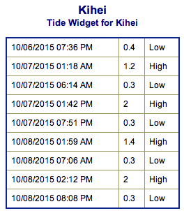
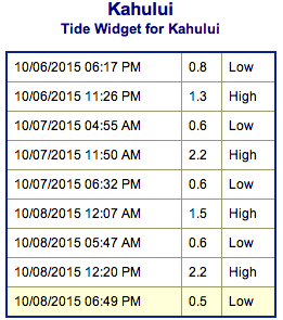
**Click directly on the images below to make them larger. Charts include: Maui County projected winds, tides, swell direction & period and expected wave heights.**
 Maui Surf Forecast
North: Wave heights are expected knee/waist high today at the best breaks. Ho’okipa area could get sets up to chest high from time to time.
West: Wave heights waist/shoulder high are expected today with top breaks reaching head high on the sets. Spots shadowed by other islands will be smaller.
South: The south-southwest is expected to bring waist/head high waves today. The best breaks could get up to overhead or more on the sets.
 Oho swell is expected to affect east-facing shores shifting east-northeast on Wednesday with a fading trend through the end of the work week.
Our new north-northwest is expected to build in Wednesday, peak Thursday and begin to fade Friday into the weekend.
Our current south-southwest peaks into Wednesday morning and fades through the end of the week.
Keep in mind, surf heights are measured on the face of the wave from trough to crest. Heights vary from beach to beach, and at the same beach, from break to break.
**Click here for your detailed Maui County weather report.**
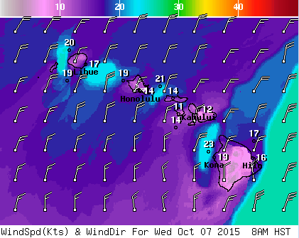
Image: NOAA / NWS

Image: NOAA / NWS

Image: NOAA / NWS
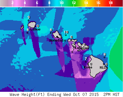
Image: NOAA / NWS
Sponsored Content


