

SSW Fading, New Swells Ahead

Image: Jimmie Hepp
Alerts (as of 1:00 a.m.)
A Small Craft Advisory is posted for all Hawaiian waters through 6 p.m. Thursday. The Pailolo and ʻAlenuihāhā channels as well as Māʻalaea Bay are under a more urgent Gale Warning.
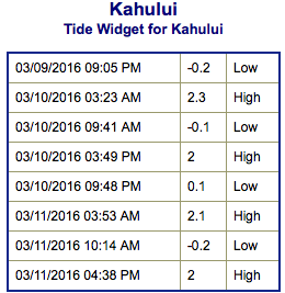
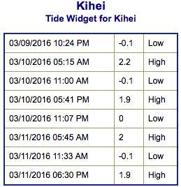
**Click directly on the images below to make them larger. Charts include: Maui County projected winds, tides, swell direction & period and expected wave heights.**
 Maui Surf Forecast
North: Many spots are expected to run chest/overhead today. Some spots may even get up to a couple feet overhead on the sets.
West: Wrap from the northwest swell affecting some western shores today. Spots along the western coast will vary greatly in size based on the amount of exposure. Ankle/knee high for shores with less exposure to the swell. Head/overhead or more for spots that get the exposure.
South: Wave heights are waist/chest high today with the best breaks reaching shoulder/head high on the sets.
 Our early season south-southwest bump is expected to gradually fade for southwest exposures through Friday. Another swell is on its heels for next weekend and peaking early next week.
Small short to mid period swell is expected for northwest exposures through today. This energy will hang around Wednesday and Thursday before fading Friday into Saturday. Another swell is possible this weekend.
Keep in mind, surf heights are measured on the face of the wave from trough to crest. Heights vary from beach to beach, and at the same beach, from break to break.
**Click here for your detailed Maui County weather report.**
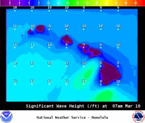
Image: NOAA / NWS
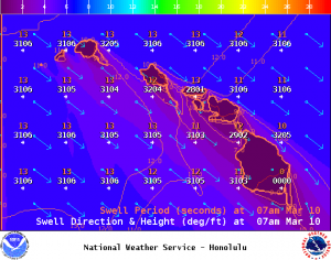
Image: NOAA / NWS

Image: NOAA / NWS
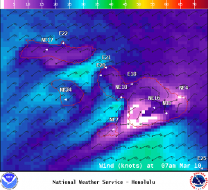
Image: NOAA / NWS
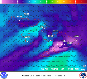
Image: NOAA / NWS
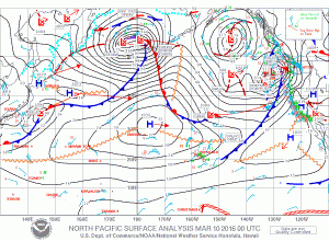
Image: NOAA / NWS
Sponsored Content


