

State Proposes Widening of 55-year-old Iao Stream Bridge
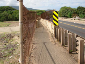
Existing pedestrian walkway at the Iao Stream Bridge. Photo courtesy DOT, Highways & Wilson Okamoto Corp.
By Wendy Osher
The state Department of Transportation is proposing improvements to widen the Iao Stream Bridge and a portion of Waiehu Beach Road leading to the bridge. The proposed improvements are aimed at enhancing the safety of motorists, bicyclists and pedestrians. The rehabilitation of the bridge would also improve the structure bringing it up to current seismic standards.
Construction of the Iao Bridge dates back to 1954, which makes it eligible to be recorded on the State Inventory of Historic Properties. It may also be eligible for nomination and listing on the Hawai’i National Register of Historic Places.

Halekii and Pihana Heiau file image by Wendy Osher.
The bridge is located makai of the Halekii-Pihana State Monument, which served as a political center during and possibly before the 18th century.
According to the Draft Environmental Assessment submitted by the state Department of Transportation, any archaeological remains in the project area have been destroyed due to the substantial alteration of the natural landscape and soils during the construction of the bridge 55 years ago, and the channelization of the stream for the flood control project of the 1970’s. Taro loi also likely existed on the banks of the stream according to previous archaeological studies.
Pre-contact human burials were documented in the sand dune system that the project site crosses, according to the DEA document. On-call archaeological monitoring is recommended for excavations that take place within the streambed itself as a part of the bridge pier monitoring. An archeological monitoring plan will be submitted to State Historic Preservation Division for review and approval prior to ground disturbance.
The section of the road lies upstream of Paukukalo Beach in the district of Wailuku. The proposed project extends a quarter mile from the Kuhio Place intersection, over the existing bridge, to the Eha Street intersection.
The State DOT identified a number of deficiencies in the current structure including inadequate width of shoulders, separation between pedestrians from the traffic lanes, and width of sidewalks. Rehabilitation is also recommended due to deterioration in sections of the roadway as well as the roadway pavement.
Comments on the DEA are being accepted through March 24th.
(Supporting information courtesy: State of Hawaii, DOT, Highway’s Division)
Sponsored Content


