

50th Anniversary of Kīlauea’s Mauna Ulu Eruption
May 24, 2019, is a notable date in Kīlauea Volcano’s history. It is the one-year anniversary of several key events in the 2018 Kīlauea eruption, most notably, the reactivation of fissure 8 with intermittent spattering while fissures 7 and 21 were producing two ‘a‘ā flows. It is also the 50th anniversary of another important event on Kīlauea’s East Rift Zone: the start of the 1969‒1974 Mauna Ulu eruption.
Fifty years ago, on May 24, 1969, the opening fissure of the Mauna Ulu eruption broke ground where Kīlauea’s east rift and the Koa‘e fault zone intersect. This fissure behaved similarly to fissures 17, 20, and 22 of the 2018 eruption with 30-m- (100-ft-) tall lava fountains emerging from a linear crack. This style of eruption is classic to Hawaii and is thus called “hawaiian fountaining” in volcanology textbooks around the world.
At Mauna Ulu, the fissure system stretched 4.5 km (3 mi) from east to west and cut straight through ‘Ālo‘i and Ala‘e pit craters within Hawaiʻi Volcanoes National Park. The fountains were confined to two main areas: one between the two pit craters and the other west of ‘Ālo‘i crater. ‘Ālo‘i crater filled with 25 m (82 ft) of lava, which then drained back into a drowned fissure vent on the crater floor, even though lava was coming out of the ground on either side of the pit crater!
On the first day of the Mauna Ulu eruption, the western fountaining zone erupted for 18 hours. The eastern zone erupted for 36 hours, but not much is known about that activity because the Chain of Craters road was cut by the western fountains, making the eastern fountains visible only in the far distance.
The five-year-long Mauna Ulu eruption was preceded by a series of East Rift Zone fissure eruptions that occurred in 1960, 1961, 1962, 1963 (2), 1965 (2), 1968 (2), and February 1969, each lasting between 1 and 15 days. At the time, there was no way to know that the eruptive activity that began on May 24, 1969, was the start of something bigger. In fact, at only 36 hours long, it seemed rather insignificant.
The episode 1 fissure produced spatter in linear ramparts several meters (yards) high on the north (upslope) side of the fissures. Ramparts did not generally form on the south side of the fissures because the spatter was rafted away on lava as it flowed downslope.
Ultimately, this brief fissure was the first of 12 lava fountaining episodes during the early Mauna Ulu eruption that continued through December 31, 1969. Beginning with episode 2, activity was localized to only the eastern fountaining zone. The vent would often have dual fountains, which erupted side-by-side, occasionally with both the same height, ranging from several tens to several hundred meters (yards) high.
The lava fountains eventually built a tephra cone 50 m (150 ft) tall. This cone, made of scoria, pumice, and yellow-gold reticulite was named Mauna Ulu (growing mountain). It was later covered in 70 m (230 ft) of lava and is a prominent landmark still visible from the Chain of Craters Road in Hawaiʻi Volcanoes National Park.
In January 1970, the Mauna Ulu eruption became effusive, producing lava flows that traveled south through the national park, and ultimately reached the ocean. A lava lake formed within the tephra cone, allowing Hawaiian Volcano Observatory researchers to document and understand gas pistoning behavior. Lava also filled in ‘Ālo‘i and Ala‘e pit craters.
After a 3.5 month pause (October 1971 to February 1972), eruptive activity resumed for two more years, until July 1974, when the eruption finally ended.
This eruption produced invaluable scientific advancements in volcano science, including an improved scientific understanding of how pāhoehoe and ‘a‘ā form. Mauna ulu provided the first detailed observations of pillow lava forming underwater—filmed by brave divers! The development of large lava flow fields, the formation of lava tubes, and the origin of tree molds were also documented.
Indeed, May 24 marks an important anniversary: The Mauna Ulu eruption was the largest, most voluminous, and best documented eruption recorded at Kīlauea in the 20th century, until 1983 when the next long-lived eruption began.
Volcano Watch is a weekly article and activity update written by US Geological Survey Hawaiian Volcano Observatory scientists and affiliates. This week’s article is by HVO geologist Carolyn Parcheta.
Volcano Activity Updates
Kῑlauea Volcano is not erupting and its USGS Volcano Alert level remains at NORMAL. For definitions of USGS Volcano Alert Levels, see https://volcanoes.usgs.gov/vhp/about_alerts.html.
Rates of deformation, gas release, and seismicity have not changed significantly over the past week.
Since early March, tiltmeters at Kīlauea’s summit have recorded modest inflationary tilt. During the same time period, a GPS station within the 2018 collapse area has recorded approximately 5 cm (3 in) of uplift. On Kīlauea’s East Rift Zone, GPS stations and tiltmeters continue to show motions consistent with refilling of the deep magmatic reservoir in the broad region between Puʻu ʻŌʻō and Highway 130. This trend has been observed since the end of the 2018 eruption.
Sulfur dioxide emission rates on Kīlauea’s ERZ and summit remain low. Gas measurements have not indicated that large volumes of magma have become significantly shallow, but HVO continues to closely monitor gas emissions at both the summit and ERZ of Kīlauea for any changes.
One earthquake with three or more felt reports occurred in Hawaiʻi this past week: a magnitude-3.0 quake 10 km (6 mi) southeast of Volcano Village at 6 km (4 mi) depth on May 19 at 4:15 p.m. HST.
Hazards remain at the lower ERZ and summit of Kīlauea. Residents and visitors near the 2018 fissures, lava flows, and summit collapse area should heed Hawai‘i County Civil Defense and Hawaiʻi Volcanoes National Park closures and warnings. Hawaiʻi County Civil Defense advises that lava flows from the 2018 eruption are primarily on private property; people are asked to be respectful and to not enter or park on private property.
The USGS Volcano Alert level for Mauna Loa remains at NORMAL.
HVO continues to closely monitor both Kīlauea and Mauna Loa for any signs of increased activity.
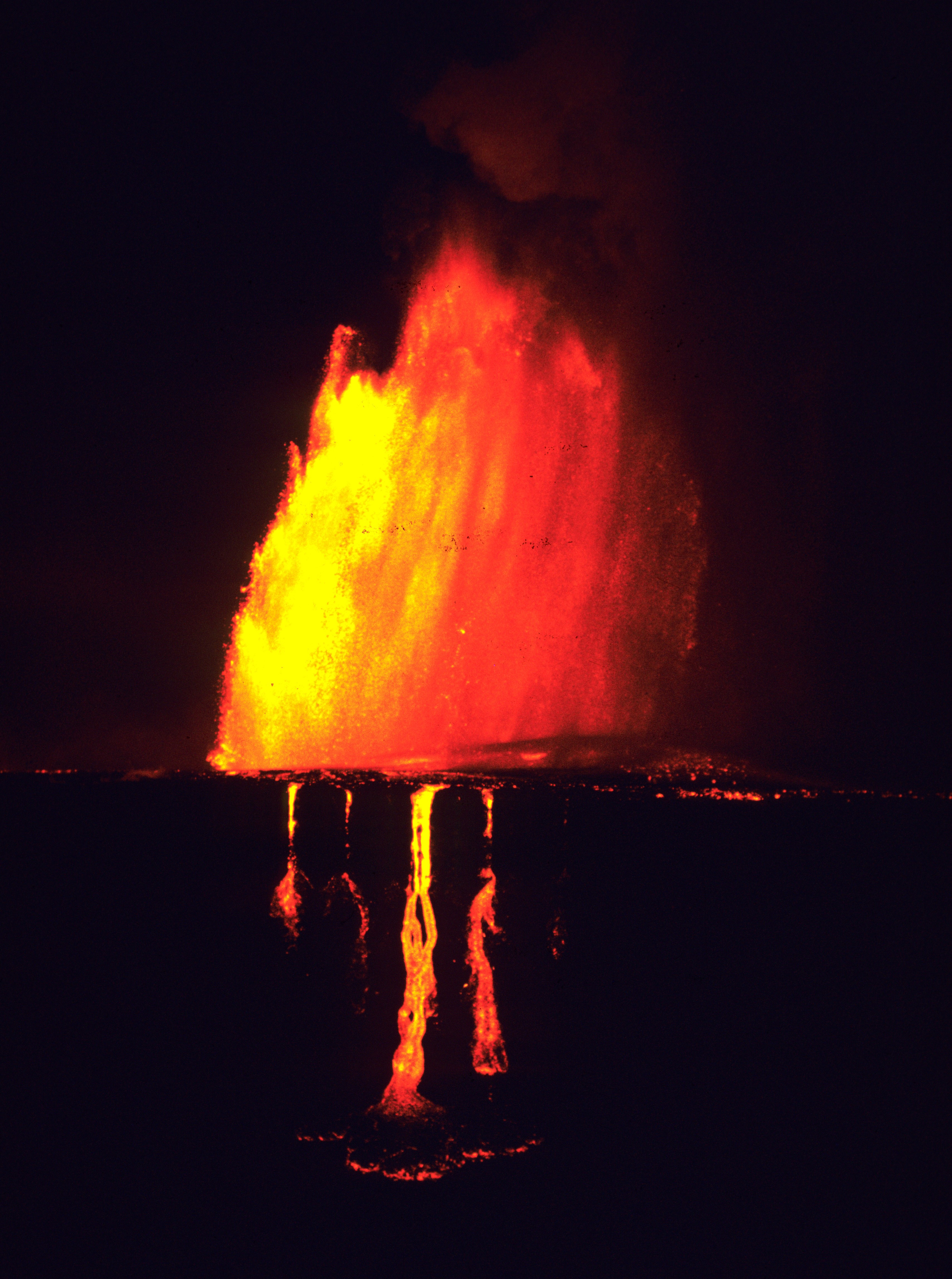
This lava fountain, which erupted on September 6, 1969, during the Mauna Ulu eruption, was about 540 m (1770 ft) tall. The tephra cone, eventually named Mauna Ulu, can be seen in the fallout area (right of the fountains. in middle of image). It is now a 121 m (397 ft) tall lava shield in Hawaiʻi Volcanoes National Park. In the foreground, lava cascades into ‘Ālo‘i crater, where it began to spread across the crater floor (bottom of image). USGS photo by D. Swanson.
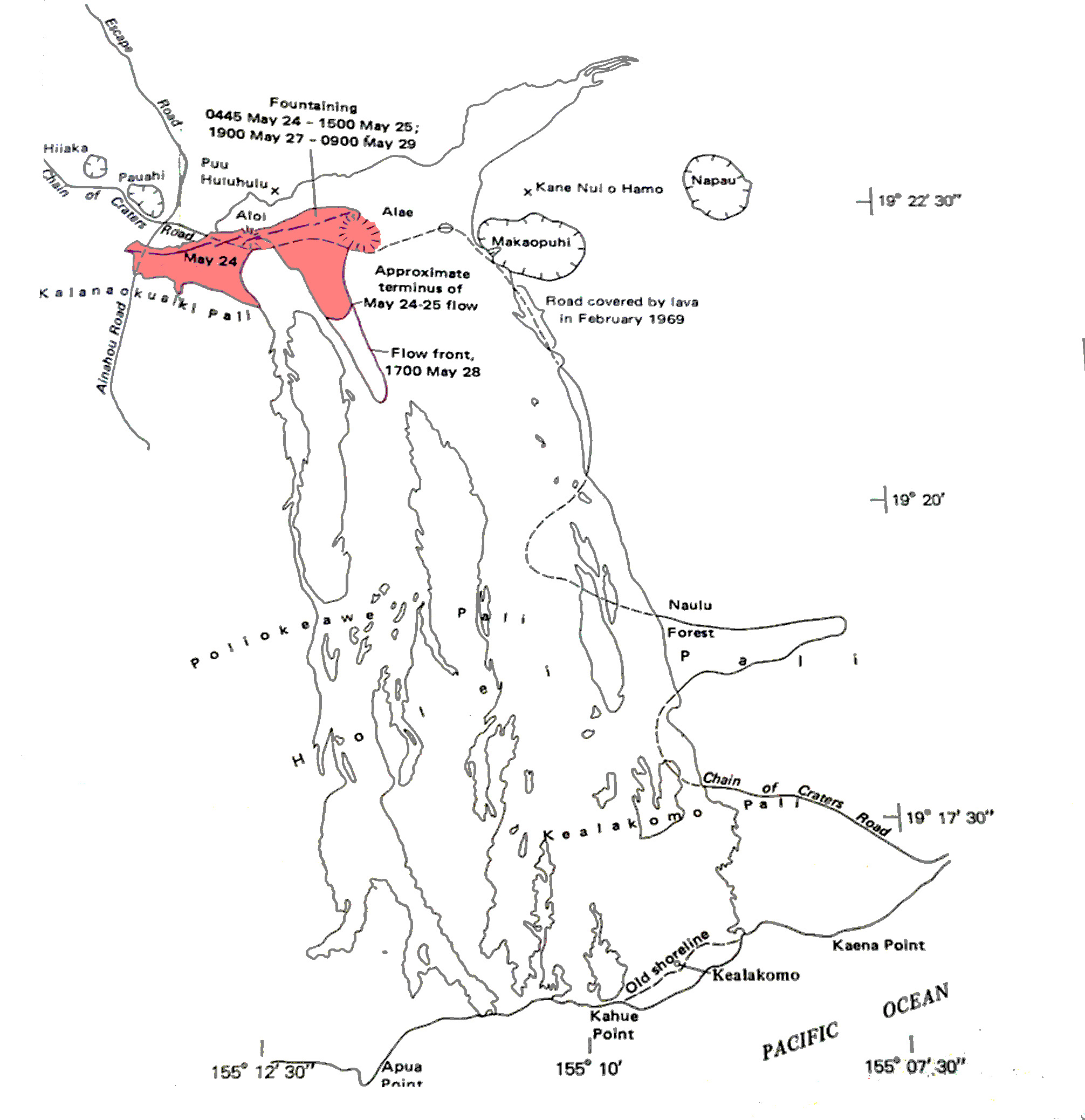
Red dashed line delineates the May 24-25, 1969, fissure of the Mauna Ulu eruption. Pink denotes the lava flow field produced by this episode 1 activity. Black lines show the extent of the flow field at the end of the Mauna Ulu eruption in July 1974. A dashed black line indicates sections of the original Hawaiʻi Volcanoes National Park Chain of Craters Road that were covered by Mauna Ulu lava. Map source: USGS Professional Paper 1056.
Sponsored Content


