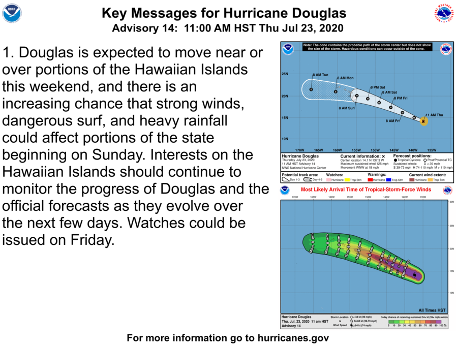
Category 3 Douglas Strengthening on Approach to Central Pacific (11 a.m. Update)
Category 3 Douglas Strengthening on Approach to Central Pacific (11 a.m. Update)
Douglas is expected to move near or over portions of the Hawaiian Islands this weekend, and there is an increasing chance that strong winds and heavy rainfall could affect portions of the state beginning on Sunday. Interests on the Hawaiian Islands should continue to monitor the progress of Douglas and the official forecasts as they evolve over the next few days.
At 11 a.m., the eye of Hurricane Douglas was located about 1235 miles ESE of Hilo (near latitude 14.1 North, longitude 137.3 West). Douglas is moving toward the WNW near 18 mph. The National Hurricane Center says “this motion is expected to continue for the next few days with a gradual decrease in forward speed and a slight turn toward the west.”
Douglas is forecast to approach the Hawaiian Islands on Sunday.
Maximum sustained winds have increased to near 125 mph with higher gusts.
Douglas has maintained its strength as a Category 3 hurricane on the Saffir-Simpson Hurricane Wind Scale. The NHC says, “Little change in strength is expected today, with gradual weakening expected to begin on Friday and continue through the weekend.”
Hurricane-force winds extend outward up to 30 miles from the center and tropical-storm-force winds extend outward up to 90 miles.


