

Powerful kona storm brings warning level winds and flash flood risks; Flood Watch continues for Maui County
The Flood Warning for the island of Maui is canceled as of 2 a.m. 1:53 a.m. on Sunday, March 15, 2026. Flood waters have receded. The heavy rain has ended. Flooding is no longer expected to pose a threat. A Flood Watch remains in effect for Kahoʻolawe, Lānaʻi, Maui, and Molokaʻi through Monday morning.
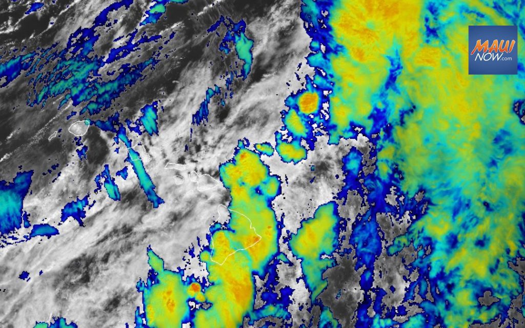
A powerful kona storm continues to hit Maui County, forcing widespread road closures from flooding, landslides, downed power lines and other infrastructure issues. The National Weather Service anticipates severe weather will last through Sunday for Maui County.
The Maui Fire Department conducted floodwater rescues overnight in Kīhei; also, dozens of people, who are now at a shelter, were cut off in Hāna due to road washout.
County of Maui officials continue to urge residents and visitors to stay off roadways unless travel is essential.
During this severe kona storm:
- Stay off the roads unless travel is absolutely necessary
- Never drive through flooded roadways
- Avoid areas with downed powerlines or debris
- Monitor official alerts and weather updates
A powerful kona storm will remain anchored northwest of the state producing periods of hazardous weather impacts across the Hawaiian Islands through the weekend. The National Weather Services says we can expect a combination of threats ranging from significant flash flooding, damaging winds, strong to severe thunderstorms, and snow and ice over the highest Big Island summits. Strong southwesterly winds will hold today produce damaging wind gusts. The highest threats for damaging winds remain along north and east slopes of island mountains.
Unsettled wet weather continues with decreasing southwesterly wind trends from Sunday into next week. This kona storm begins to lift northeastward from Sunday to Monday, heavy rain and strong winds will decrease as severe weather conditions start to ease across Hawaiʻi. However, periods of unsettled wet weather in a light and variable low level wind pattern will continue across the state into next weekend, according to the NWS.
A High Wind Warning is in effect for Maui County through 6 a.m. on Sunday. Island wide strong gusty winds are possible, but areas most at risk are communities north and east of steep mountains. The forecast calls for southwest winds 25 to 40 mph with gusts up to 60 mph in Kauaʻi County, Oʻahu and Maui County.
A High Wind Warning is also in effect for the summits of Haleakalā on Maui and the Big Island summits through 6 p.m. Sunday. The forecast calls for southwest winds 55 to 75 mph with gusts up to 110 mph. A High Wind Warning means that winds at the summits are expected to be at least 56 mph, with gusts over 66 mph. Take necessary precautions to protect property. Travel to summit areas should be delayed until winds subside.
A Flood Watch is now in effect for Maui County through 6 a.m. Monday. Considerable flash flooding is possible as a large and powerful kona storm northwest of the state draws deep tropical moisture across the islands. Persistent bands of heavy rain and thunderstorms may produce intense rainfall rates, leading to rapid rises in streams and flooding of roads and low-lying areas.
A powerful kona storm is producing periods of hazardous weather impacts across the Hawaiian Islands through the weekend. Threats range from significant flash flooding, damaging winds, strong to severe thunderstorms, and snow and ice over the highest Big Island summits.
The National Weather Service reports southerly to southwesterly winds will be strongest from today to tomorrow and will produce damaging wind gusts. “The highest threats for damaging winds remain along north and east of the island mountains. Unsettled wet weather conditions with decreasing southwesterly wind trends will continue into early next week,” the NWS reports.
This kona storm begins to lift northward on Monday, and unsettled weather will start to ease across the state. High pressure will build back in north of the state on Wednesday allowing trade winds to return spreading from north to south down the island chain reaching Maui and the Big Island by Thursday morning.
Previous posts:
A Flash Flood Warning has been extended for the island of Maui until 2 a.m. on Sunday, March 15. At 10:55 p.m., rainfall across Maui has diminished, with mainly light to moderate showers moving through the southeast and eastern sections of the island. However, runoff from earlier rainfall continues to keep streams elevated. Maui Emergency Management reports that the Highway near ʻOheʻo Gulch in East Maui and in one lane near Hāna remain closed due to ongoing flooding.
At 7:59 p.m., radar showed that the heaviest rainfall has shifted to the windward and southeast sections of Maui, with current rainfall rates generally down to around 0.5 to 1 inch per hour. Although the rainfall rates have decreased, runoff from earlier heavy rainfall continues to keep streams elevated. Emergency Management reports the highway near Hāna remains closed this evening in both directions due to flooding. Flooding has also been reported in Lahaina, with additional flooding possible through the late evening hours due to runoff and drainage.
At 5 p.m., radar showed heavy rainfall over the island of Maui with stream levels continuing to increase. Rain was falling at a rate of 1.5 to 3 inches per hour with additional heavy rain expected to move in from the southwest. Emergency Management continues to report multiple roads closed due to flooding along with landslides and sinkholes.
At 3:33 p.m., radar and stream data indicated heavy rain continuing over the island of Maui. Rain was falling at a rate of 1 to 2 inches per hour with additional heavy rain expected to move in from the southwest. Emergency Management continues to report multiple roads closed due to flooding along with landslides and sinkholes.
At 1:20 p.m., radar showed moderate to heavy rain continuing over the island of Maui. Rain was falling at a rate of half an inch to 1 inch per hour. The heaviest rain was falling over the south-facing slopes of Haleakalā between Mākena and Hāmoa with additional rain expected to move in from the southwest. Emergency Management continues to report multiple roads closed due to flooding.
At 10:05 a.m., radar showed moderate to heavy rain continuing over the island of Maui. Some streams have risen, and more heavy rain can be observed to the southwest approaching the island. The heaviest rain was falling over the south-facing slopes of Haleakalā between Mākena and Hāmoa.
A Flash Flood Warning is in effect for the island of Molokaʻi until 11 p.m. At 8:16 p.m., Rainfall across Molokaʻi has diminished this evening. However, runoff from earlier rainfall continues to keep streams elevated, particularly along Kawela Gulch. Emergency Management reports that Kamehameha Highway near Kawela Gulch or around mile marker 35 remains closed this evening due to ongoing flooding.
At 6:32 p.m., Rainfall across Molokaʻi has diminished this evening. However, runoff from earlier rainfall continues to keep streams elevated, particularly along Kawela Gulch and nearby drainages.
At 3:53 p.m., radar showed moderate to heavy rain moving over Molokaʻi from the southwest at a rate of half an inch to 1 inch per hour. Streams across the island have also increased significantly. Additional rainfall is expected.
The Flash Flood Warning that was in effect for Molokaʻi has since been canceled as of 10:15 a.m. Heavy rain has diminished and stream levels have decreased. A Flood Watch remains in effect until 6 a.m. Monday for Kahoʻolawe, Lānaʻi, Maui, and Molokaʻi.

Sponsored Content


