Forecasters monitor Tropical Storm Fausto in the Eastern North Pacific
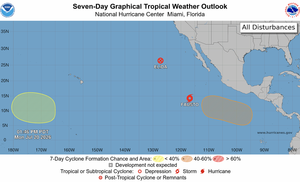
Tropical Storm Fausto, located several hundred miles southwest of the southern tip of Baja California in the Eastern North Pacific, is forecast to become a Hurricane by Tuesday as it continues a path northwest near 10 mph.
Fausto is expected to approach major hurricane status in a couple of days, according to the National Hurricane Center. Gradual weakening is expected toward the end of the week once Fausto moves into an environment of progressively cooler waters and drier air, the NHC reports.
“A decrease in forward speed and a motion toward the northwest is expected to continue for the next day or two. A turn back to the west-northwest is expected on Wednesday,” according to the latest forecast.
Maximum sustained winds are near 70 mph with higher gusts and tropical-storm-force winds extend outward up to 140 miles from the center.
The National Hurricane Center has issued its last advisory on Post-Tropical Cyclone Elida, located well west-northwest of the southern tip of the Baja California Peninsula.
Southwest of Hawaiʻi, showers and thunderstorms associated with a trough of low pressure located well southwest of the Hawaiian Islands remain disorganized, the National Weather Service reports. “Environmental conditions appear conducive for some gradual development of this system as it moves generally westward during the next several days,” according to the NWS.
Forecasters with the NOAA National Weather Service Honolulu Forecast Office are predicting an above-normal hurricane season for the central Pacific basin this year. NOAA’s outlook for the 2026 hurricane season, which runs June 1 to Nov. 30, predicts a 70% chance of an above-normal season, with a total of 5-13 tropical cyclones across the central Pacific.
Sponsored Content