Maui County Council panel confronts infrastructure deficiencies and costs in South Maui plan update

Maui County Council members are four days into a close, section-by-section review of the South Maui Community Plan update—and they’re running into hard questions about whether the county can deliver on the plan’s goals and designated growth areas.
The Council’s Disaster Recovery, International Affairs and Planning Committee has spent this past week in Council Chambers working through the draft plan, Bill 108 (2026), after conducting site inspections in South Maui and hearing testimony in Kīhei on Monday. At issue: whether the plan adequately addresses infrastructure deficiencies in a region that has often developed ahead of the water, wastewater, flood-control and roadway systems needed to support it—and who will pay to catch up. In post-wildfire Maui, committee members and testifiers have also pressed an urgent question: whether evacuation routes are sufficient, given the brush and grassland mauka of Kīhei, Wailea and Mākena.
The South Maui Community Plan is one of nine community plans tied to the Maui County General Plan, each required to be updated every 10 years “to the extent practicable.” The current update process, which will replace the 1998 Kīhei-Mākena Community Plan, began in 2020, with work stalled for a stretch by COVID-19 restrictions on in-person meetings. The Community Plan Advisory Committee reviewed the draft from October 2022 to November 2023, and the Maui Planning Commission reviewed it from May 2024 to March 2025 before transmitting it to the Council.
A plan with blank price tags
Kula resident Dick Mayer, a longtime community advocate, told the committee Tuesday that the plan’s Section 4— the implementation schedule listing every capital project tied to the plan’s goals—contains 145 action items, but only eight carry an actual cost estimate. Sixty-five have no cost figure at all, he said, and 15 more are marked “not applicable.” The dollar amounts that are listed already total $554 million, he said, without accounting for the items left blank.
“So you don’t know what the overall financial burden will be on the county budgets in the future, on the private developers, if they’re expected to put in funding,” Mayer said.

“It should be a fiscally sound plan, [but] you have no plan,” Mayer told the committee. “Even though you have a long list of projects, you do not have an overall number [for] how much that will cost and whether the money will be available—whether it’s likely the state, or the federal [government], or particularly the county will be able to finance the changes that will be needed.”
A review of the draft plan’s implementation schedule bears that out—and shows the gap falls unevenly across infrastructure types. Appendix H, the plan’s dedicated capital-improvement priority list, ranks 15 transportation projects—road widening, the Kīhei North-South Collector, bike paths, a transit hub study—with a combined cost of estates at $373 million in 2022 dollars, fully itemized. No comparable prioritized, cost-summed list exists for water or wastewater infrastructure in the plan.

Water: A big question for South Maui development
Earlier this month during discussion of the proposed the EC Paia project before the Maui Planning Commission, the Department of Water Supply reported in an Aug. 14 letter that the Central Maui water system is at 98% to 100% of its maximum reliable capacity, with “no additional source capacity” available for new or expanded service.
South Maui relies on imported water from Central Maui, primarily the ʻĪao aquifer. On Page 24 of the draft plan, it says it’s a “significant challenge” to ensure there’s sufficient water and other infrastructure for existing and new development in South Maui.

Maui Now asked the Department of Water Supply about the sufficiency of water for South Maui. Via email, it said:
“The county water system serving South Maui is sourced by wells and a surface water treatment plant in Central Maui, with approximately 8.3 million gallons per day of South Maui’s water supply coming from the ʻĪao aquifer. Capacity studies indicate that Central Maui water resources are near capacity under conservative conditions that account for potential limitations and reflect reliable capacity after considering realistic source and system constraints. DWS uses this analysis when evaluating water service requests and continues to evaluate other options to meet future needs.”
The plan’s “Utilities” action items, covering water conservation and reuse, total roughly $25.6 million in itemized costs across four projects—recycled water expansion, a desalination feasibility study, a potable-reuse feasibility study and a drought management plan update. A fifth utility item, expanding water-reuse infrastructure, carries no cost estimate. On Page 127, in the plan’s coastal and sea-level-rise category, a separate item identified as a high priority requires converting cesspools in Māʻalaea and Maui Meadows to regional wastewater treatment by 2030—with no cost estimate attached. Instead, it’s cost is TBD, or to be decided.
Housing entitlements outpace stated need, critic says
Albert Perez, executive director of the Maui Tomorrow Foundation, urged the committee to reject roughly 3,500 additional housing units proposed in the draft plan for North Kīhei, the Piʻilani Promenade area and a conversion of the Wailea Golf Course to luxury housing.
“They’re all unnecessary,” he said Tuesday.
South Maui already has roughly 4,500 units entitled, he said—far more than the 1,700 the county’s own research identified as needed—while the region still has only one evacuation route.

“We cannot continue to give away our scarce infrastructure resources to wealthy outsiders, while asking local residents to pay the price,” Perez said. He called for restoring an “infrastructure concurrency” requirement to the plan—the principle that growth should pay for the infrastructure it requires, rather than leaving the county to absorb the cost.
Perez returned Thursday to reiterate concerns about developing in flood-prone areas, pointing to chronic flooding in the Kūlanihakoʻi watershed as a reason to reject growth planned for North Kīhei Mauka.
“It’s really important that we stop developing in flood zones and wetlands, particularly affordable housing,” he said. “These are people, when they can finally afford a home, then they get flooded out. They’re least able to afford all the damage to their properties and personal possessions.”
Maui Now put testimony from Mayer and Perez to the Department of Planning on Friday and asked for a response by the end of the day. Planning Director Jacky Takakura replied in writing.
Planning Department responds
On the housing numbers, Takakura referred the figures Perez cited, while offering a different view of them. Of 8,052 housing units referenced in the materials testifiers cited, 4,552 are already approved, she said—leaving roughly 3,500 identified for potential future development, consistent with what Perez told the committee. Many of the already-approved projects, she said, “are not expected to be built in the near term and may be decades away,” naming Kīhei Mauka, Honuaʻula, Mākena, Piʻilani Promenade and the former Wailea Golf Course property specifically.

“The purpose of identifying these areas in the community plan is to allow the County to plan for infrastructure needs in advance,” Takakura wrote. “Both the existing Kīhei-Mākena Community Plan and the draft South Maui Community Plan call for infrastructure to be provided before or concurrent with development. That approach is not changing.”
On the missing cost figures, Takakura said Appendix H—the capital-improvement list—was added specifically to provide project and cost estimates, using 2022 dollars, and was developed with the relevant county departments “where costs could be reasonably determined at this stage.” More current, detailed figures come later, through the county’s annual Capital Improvement Program budget process, she said, describing the plan’s estimates as “a snapshot in time for a plan that spans 20 years.”
“The Department recognizes that implementing the infrastructure identified in the plan will require substantial investment,” Takakura wrote. “However, development will occur over an extended period rather than all at once.” She said the department can pull additional detail on specific proposed actions from the county departments responsible for them, if the Council wants it.
On Mayer’s objection to the bill’s shift from “shall” to “will,” Takakura said the change was made to conform with Office of Council Services drafting guidelines required for transmitting the legislation, not to weaken it. “The Planning Department does not agree that the use of ‘will’ makes the plan less effective, vague or unenforceable,” she wrote.
Takakura also stressed that the community plan itself does not approve individual projects. “Future projects will remain subject to applicable County requirements and review processes, including requirements related to infrastructure,” she wrote. “The community plan provides a framework for anticipating future growth and identifying infrastructure needs so that the County can plan accordingly.”
Committee chair wants answers
By Friday morning, the concern had moved from public testimony into the committee’s own deliberations. Committee Chair Tamara Paltin told members she wants formal guidance from the Department of the Corporation Counsel on what the community plan ordinance requires on fiscal impacts, citing testimony and members’ own unease about the roughly $500 million in listed costs, before the committee takes up Section 4.

Wildfire evacuation concerns raised
Testifiers also focused on the limited number of “escape routes” from South Maui if there were a wildfire or tsunami.
Jeanne Schaaf said wildfire safety must be a fundamental planning constraint.
“The Maui wildfires demonstrated the devastating consequences that can occur when development, evacuation, infrastructure and emergency response are not adequately planned for catastrophic wildfire,” she said. “The plan should identify evacuation constraints, emergency access limitations, areas of elevated wildfire risk and the infrastructure improvements necessary before additional development is permitted.”
In written testimony, Mark Hyde said wildfire risk is high in South Maui and insufficiently addressed in the draft plan. Citing figures in the plan, he said more than 50,000 people are in South Maui on any given day (29,000 residents and 26,500 visitors), not including residents who work in the resort area but live elsewhere.
South Maui has only two roads in and out—North Kīhei Road, which transitions to South Kīhei Road and Maui Veterans Highway, which transitions to Piʻilani Highway—and those converge about 100 yards in “bottleneck fashion” in North Kīhei, he pointed out.
He noted that sections of South Kīhei Road washed out during recent Kona Low storms.
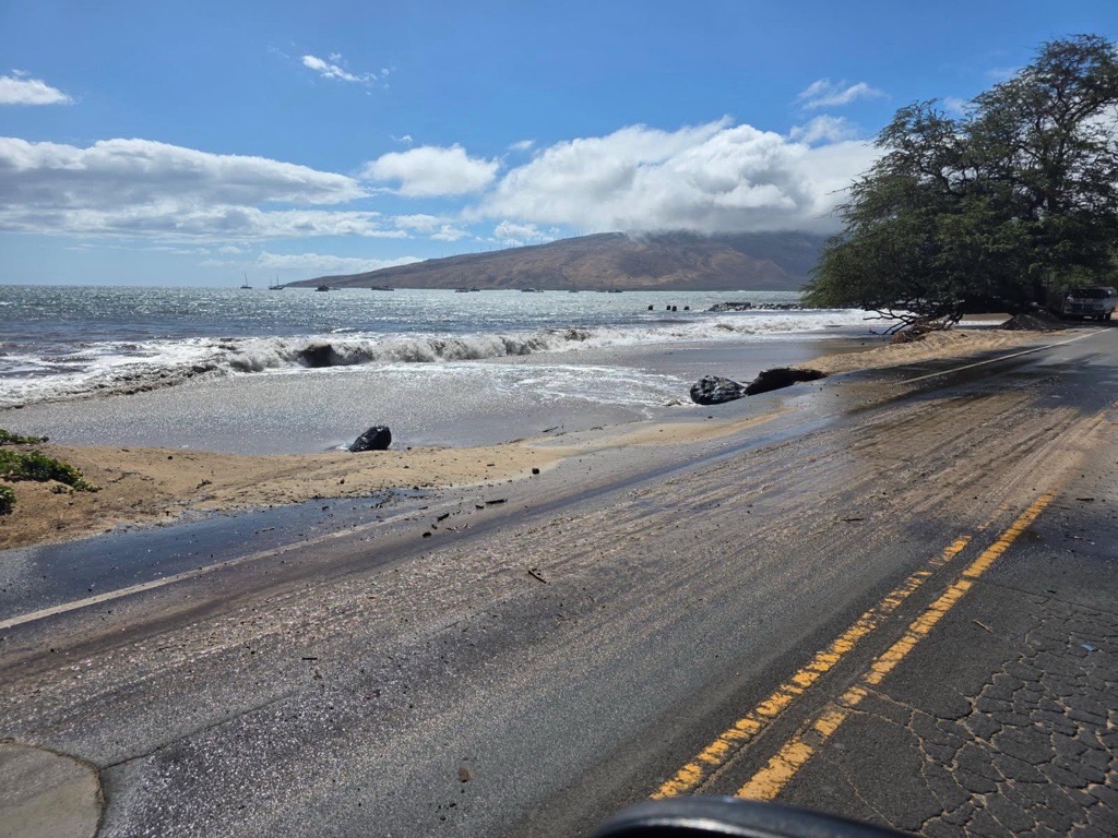
Hyde quoted from the plan that says “South Maui’s coastal-focused development and extensive stretches of ranch lands make it vulnerable to natural hazards and emergencies. The risk for hazard in emergency events will likely increase in frequency and severity due to climate change and sea level rise. These risks are compounded by the fact that there are only two primary roads in and out of the plan area.”
South Maui traffic volume increased 3% per year between 2014 and 2018, he said, again citing information in the draft plan.
Next week, committee meetings are scheduled for 9 a.m. Monday and Wednesday.
The county has until Aug. 4, 2027, to adopt the South Maui Community Plan, Paltin told committee members.
Sponsored Content