

8 p.m. UPDATE: 10/16/14, Tropical Storm Warning Issued, Public Urged to be Vigilant
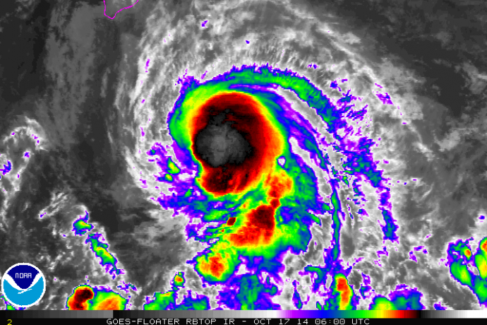
8 p.m. Satellite imagery, p.m. HST, Thursday, Oct. 16, 2014, courtesy NOAA/NWS.
By Meteorologist Malika Dudley
***An update as of 11 p.m. on Thursday, Oct. 16, 2014, is now posted at the following LINK.
The latest update on Tropical Storm ANA was just released by the Central Pacific Hurricane Center. Ana has gotten stronger since the last update at 5 p.m. A tropical storm warning has also been issued for leeward and southeast waters of the Big Island. The National Weather Service urges the public to not let their guard down just because Maui County and the Big Island are no longer in the cone of error. There is still a great deal of uncertainty with the track which is why all of the alerts listed below still stand. Having said the the statistical chance of tropical storm conditions has continued to decrease for all areas under the tropical storm watch.
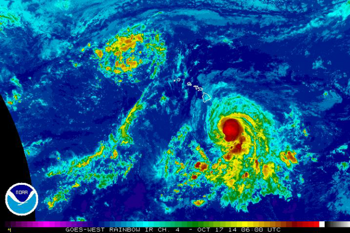
8 p.m. Satellite imagery, p.m. HST, Thursday, Oct. 16, 2014, courtesy NOAA/NWS.
Summary of Alerts:
HURRICANE WARNING – All Hawaiian Offshore Waters / Starting Friday PM
TROPICAL STORM WARNING – All Hawaiian Offshore Waters / Big Island leeward coastal waters and Big Island southeast waters
TROPICAL STORM WATCH – Hawaiʻi County / Maui County Leeward Waters & Parts of ʻAlenuihāhā Channel.
FLASH FLOOD WATCH – Big Island / Entire state beginning Friday at noon
Current situation:
Maximum sustained winds are at 65 mph
Ana is moving west-northwest at 12 mph
Tropical storm force winds extend 60 miles from the center of the system
Tropical Storm Ana was last located near 14.9 N and 152.5 W, about 370 miles SSE of Hilo, Hawaiʻi; 485 miles SE of Kahului, Maui; 530 miles SE of Kaunakakai, Molokaʻi; 500 miles SE of Lānaʻi City; and 565 miles SE of Honolulu, Oʻahu on Thursday, Oct. 17, 2014 at 8 p.m.
A weak high pressure ridge to the north of the state that has been steering the storm is weakening and Ana has started to turn west-northwest, possibly becoming a hurricane on Friday. Friday night and Saturday increased wind shear will weaken ANA back down to tropical storm status.
Forecast & Uncertainty:
The current track has ANA passing 120 miles southwest of the island of Hawaii Friday night and south of Maui County Saturday. Though the island of Hawaiʻi and Maui County are no longer in the cone of uncertainty, keep in mind the center of the storm could fall along the upper edge and if that happens the storm could still have potentially serious impacts. Oahu, Kauaʻi and Niʻihau are all still within the cone of uncertainty.
The probability of tropical storm conditions for Maui leeward waters is 30-40%; 15% in Hilo; 28% in Kailua-Kona and 37% near South Point.
Potential Impacts (if the track holds):
Still plenty of uncertainty on the forecast track. Heavy rain may reach the Big Island late Friday potentially causing dangerous flash flooding with excessive runoff causing possible mud slides and rock slides. Flooding is possible statewide and the National Weather Service anticipate issuing a flash flood watch for the entire state tomorrow at noon.
Large dangerous surf conditions are expected to begin impacting the eastern end of the Hawaiian islands spreading westward through the weekend. Additional storm surge of 1 -2 feet for southeastern shores.
Increasing winds to 30 mph. Gusts could reach 50 mph as the center of ANA passes.
Big Island –
6 to 8 inches with locally up to 12 inches along southeast facing slopes beginning Friday afternoon.
Winds of 25 to 40mph, gusting to 50 mph are possible Friday/Saturday
Seas of 15 to 25 feet. Surf heights up to 20 feet are possible late Friday along the Puna & Kaʻū coastlines during the closest approach. Elevated surf of up to 12 feet is possible along the Kona coasts Saturday.
Maui County –
Seas of up to 15 feet are possible for leeward coastal waters starting Saturday morning
Winds of 20 – 30 mph winds, gusting to 35 mph are possible Saturday afternoon & evening / Strongest winds on southwest side of Maui County, particularly Lānaʻi and Molokaʻi
Locally heavy rainfall, frequent scattered showers, thunderstorms possible starting Friday – 5 to 10 inches with higher amounts possible.
Tropical Storm conditions possible Saturday / Sunday
Oʻahu –
Tropical Storm conditions possible late Saturday
Locally heavy rainfall, frequent scattered showers, thunderstorms – 5 to 10 inches with higher amounts possible
Winds of 20 – 30 mph winds, gusting to 35 mph building Saturday
Kauaʻi –
Effects felt generally about 18 hours after Oʻahu
Possibility of locally heavy rainfall, frequent scattered showers, thunderstorms – 5 to 10 inches with higher amounts possible
Winds of 20 – 30 mph winds, gusting to 35 mph
Sponsored Content


