

11am UPDATE: 10/17/14, ANA Upgraded to Hurricane Status
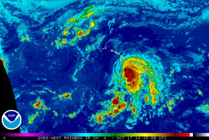
Satellite imagery, 10 a.m. HST, Friday, Oct. 17, 2014, courtesy NOAA/NWS.
By Maui Now Staff / Meteorologist Malika Dudley
***A new hurricane update as of 2 p.m. on Friday, Oct. 17, 2014, is now posted at the following LINK.
Ana was upgraded to a hurricane shortly before 11 a.m. today.
A tropical storm watch has also been issued for Maui County, Oʻahu, and Kauaʻi counties, including adjacent coastal waters.
Summary of Alerts:
TROPICAL STORM WATCH – Statewide / All coastal waters
HURRICANE WARNING – All Hawaiian Offshore Waters / Starting Friday PM
TROPICAL STORM WARNING – All Hawaiian Offshore Waters / Big Island leeward coastal waters and Big Island southeast waters
FLASH FLOOD WATCH – Big Island / Anticipated for the entire state beginning Friday afternoon
Current situation:
Maximum sustained winds are at 75 mph, gusting to 93 mph
Ana is moving west-northwest at 14 mph
Hurricane force winds extend 25 miles from the center. Tropical storm force winds extend 90 miles from the center of the system.
At 11 a.m. HST, on Friday, Oct. 17, the center of Tropical Storm Ana was last located near 16.4 N and 155.2 W, about 230 miles S of Hilo, Hawaiʻi; 320 miles SE of Kahului, Maui; 350 miles SE of Kaunakakai, Molokaʻi; 325 miles SE of Lānaʻi City; and 380 miles SSE of Honolulu, Oʻahu.
A slight turn to the northwest is expected today and Saturday. A decrease in forward speed is expected Saturday night and Sunday. On this forecast track, the center of Ana will pass about 115 miles southwest of the Big Island tonight and about 115 miles southwest of the rest of the main Hawaiian islands this weekend. Some strengthening is expected today. The system is expected to weaken a little slower than in the last update starting late Saturday.
ANA is expected to get nudged slightly northwest later today. A new ridge is expected to form north of our islands just as ANA would be approaching Oʻahu and Kʻauai, if the forecast holds true, this would help to slow the forward motion of the system (not so good – increased flooding potential) and steer it west (good – away from the islands).
Uncertainty:
The probability of tropical storm conditions continues a gradual downward trend – for Maui leeward waters it’s 34%; 8% in Hilo; 16% in Kailua-Kona and 20% near South Point.
Potential Impacts (if the track holds):
Heavy rain and thunderstorms are expected for the Big Island today – potentially causing dangerous flash flooding with excessive runoff causing possible mud slides and rock slides in steep terrain. Flooding is possible statewide over the weekend state. These heavy rain conditions are likely to sweep up the island chain from east to west through the weekend.
Large dangerous surf conditions will impact the eastern end of the Hawaiian islands spreading westward through the weekend as well. Additional storm surge of 1 -2 feet for southeastern shores is likely.
Winds are expected to increase to 35 mph. Gusts could reach 50 mph or more as the center of ANA passes. Highest winds will be through mountainous terrain, valleys and passes.
Maui County –
Seas of up to 15 feet are possible for leeward coastal waters starting Saturday morning
Winds of 20 – 30 mph winds, gusting to 35 mph are possible Saturday afternoon & evening / Strongest winds on southwest side of Maui County, particularly Lānaʻi and Molokaʻi
Locally heavy rainfall, frequent scattered showers, thunderstorms possible starting Friday – 5 to 10 inches with higher amounts possible.
Tropical Storm conditions possible Saturday / Sunday
NOTE: Keep in mind, this is a large system and not a single point – as the track may lead you to believe – it’s becoming quite apparent on radar just how big this system is when compared to our land masses in the Hawaiian islands. Slight deviations to the right could have significant negative impacts on the effects we see to our island weather. Slight deviations to the left could similarly have a positive effect on our weather. Closely monitoring the system and the impending conditions as ANA continues to approach is a smart idea.
Sponsored Content


